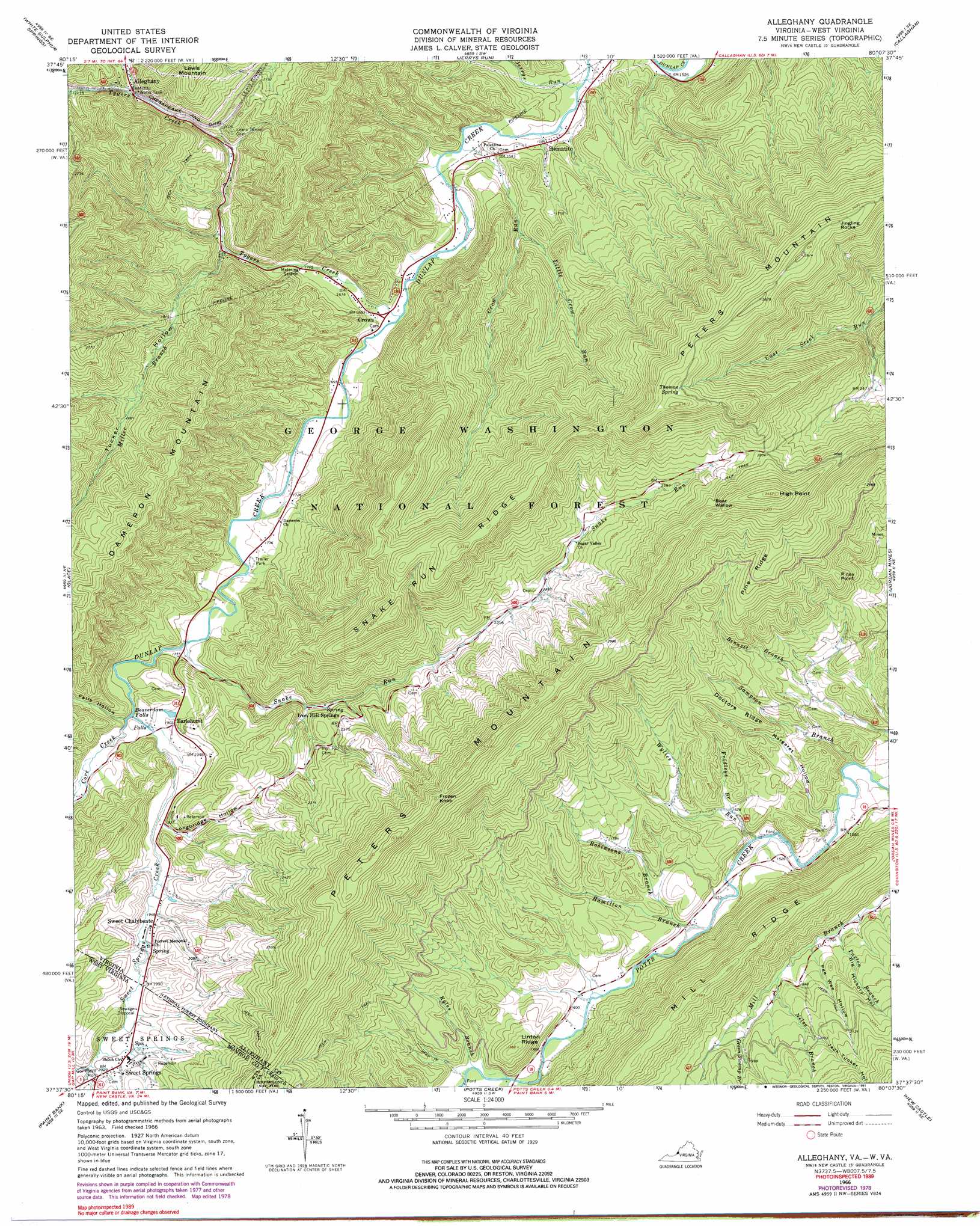
Alleghany Topo Map Virginia
To zoom in, hover over the map of Alleghany
USGS Topo Quad 37080f2 - 1:24,000 scale
| Topo Map Name: | Alleghany |
| USGS Topo Quad ID: | 37080f2 |
| Print Size: | ca. 21 1/4" wide x 27" high |
| Southeast Coordinates: | 37.625° N latitude / 80.125° W longitude |
| Map Center Coordinates: | 37.6875° N latitude / 80.1875° W longitude |
| U.S. States: | VA, WV |
| Filename: | o37080f2.jpg |
| Download Map JPG Image: | Alleghany topo map 1:24,000 scale |
| Map Type: | Topographic |
| Topo Series: | 7.5´ |
| Map Scale: | 1:24,000 |
| Source of Map Images: | United States Geological Survey (USGS) |
| Alternate Map Versions: |
Alleghany VA 1966, updated 1968 Download PDF Buy paper map Alleghany VA 1966, updated 1978 Download PDF Buy paper map Allegany VA 1966, updated 1991 Download PDF Buy paper map Alleghany VA 2011 Download PDF Buy paper map Alleghany VA 2013 Download PDF Buy paper map Alleghany VA 2016 Download PDF Buy paper map |
| FStopo: | US Forest Service topo Alleghany is available: Download FStopo PDF Download FStopo TIF |
1:24,000 Topo Quads surrounding Alleghany
Williamsburg |
Anthony |
Alvon |
Rucker Gap |
Falling Spring |
Lewisburg |
White Sulphur Springs |
Jerrys Run |
Callaghan |
Covington |
Ronceverte |
Glace |
Alleghany |
Jordan Mines |
Strom |
Gap Mills |
Paint Bank |
Potts Creek |
New Castle |
Oriskany |
Waiteville |
Craig Springs |
Looney |
Catawba |
Daleville |
> Back to 37080e1 at 1:100,000 scale
> Back to 37080a1 at 1:250,000 scale
> Back to U.S. Topo Maps home
Alleghany topo map: Gazetteer
Alleghany: Cliffs
High Point elevation 1051m 3448′Piney Point elevation 708m 2322′
Alleghany: Falls
Beaverdam Falls elevation 548m 1797′Alleghany: Parks
Government Floyd Monument elevation 620m 2034′Lynnside Historic District elevation 620m 2034′
Alleghany: Populated Places
Alleghany elevation 628m 2060′Crows elevation 499m 1637′
Earlehurst elevation 581m 1906′
Hematite elevation 486m 1594′
Iron Hill Springs elevation 658m 2158′
Sweet Chalybeate elevation 595m 1952′
Sweet Springs elevation 620m 2034′
Alleghany: Post Offices
Sweet Springs Post Office elevation 611m 2004′Alleghany: Ridges
Doctors Ridge elevation 603m 1978′Linton Ridge elevation 600m 1968′
Mill Ridge elevation 769m 2522′
Pine Ridge elevation 823m 2700′
Snake Run Ridge elevation 993m 3257′
Alleghany: Springs
Lynnside Spring elevation 614m 2014′Old Sweet Springs elevation 613m 2011′
Rowan Memorial Home Spring elevation 642m 2106′
Sweet Chalybeate Springs elevation 600m 1968′
Thomas Spring elevation 1061m 3480′
Alleghany: Streams
Bennett Branch elevation 516m 1692′Cove Creek elevation 548m 1797′
Cove Creek elevation 548m 1797′
Crow Run elevation 481m 1578′
Fall Hollow Branch elevation 549m 1801′
Fridleys Branch elevation 492m 1614′
Green Swamp Branch elevation 574m 1883′
Hamilton Branch elevation 470m 1541′
Jerrys Run elevation 470m 1541′
Kyles Branch elevation 491m 1610′
Little Crow Run elevation 549m 1801′
Miller Branch elevation 535m 1755′
Nelse Branch elevation 553m 1814′
Paxton Branch elevation 531m 1742′
Robinson Branch elevation 483m 1584′
Sampson Branch elevation 466m 1528′
Shawvers Run elevation 491m 1610′
Snake Run elevation 533m 1748′
Sweet Spring Creek elevation 548m 1797′
Sweet Springs Creek elevation 549m 1801′
Toms Branch elevation 613m 2011′
Tygers Creek elevation 497m 1630′
Wylies Run elevation 459m 1505′
Alleghany: Summits
Bear Wallow elevation 921m 3021′Dameron Mountain elevation 880m 2887′
Frozen Knob elevation 976m 3202′
Jingling Rocks elevation 1021m 3349′
Sweet Springs Mountain elevation 957m 3139′
Alleghany: Tunnels
Lewis Tunnel elevation 647m 2122′Alleghany: Valleys
Big Hickory Hollow elevation 531m 1742′Falls Hollow elevation 548m 1797′
Jack Tucker Hollow elevation 597m 1958′
Longbridge Hollow elevation 588m 1929′
Margaret Hollow elevation 457m 1499′
Pee Wee Hollow elevation 560m 1837′
Sweet Springs Valley elevation 566m 1856′
Tucker Hollow elevation 535m 1755′
Alleghany digital topo map on disk
Buy this Alleghany topo map showing relief, roads, GPS coordinates and other geographical features, as a high-resolution digital map file on DVD:
Western Virginia & Southern West Virginia
Buy digital topo maps: Western Virginia & Southern West Virginia