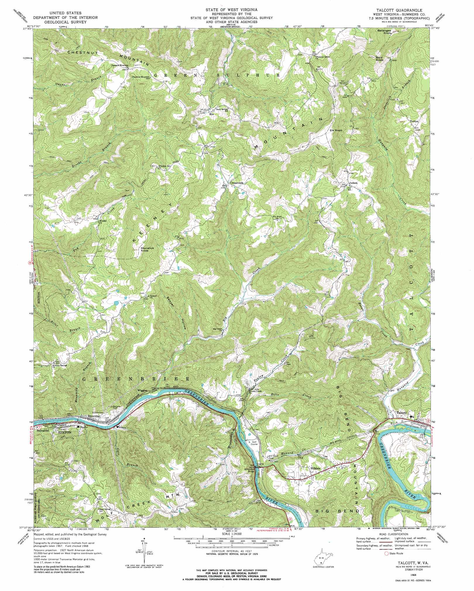
Talcott Topo Map West Virginia
To zoom in, hover over the map of Talcott
USGS Topo Quad 37080f7 - 1:24,000 scale
| Topo Map Name: | Talcott |
| USGS Topo Quad ID: | 37080f7 |
| Print Size: | ca. 21 1/4" wide x 27" high |
| Southeast Coordinates: | 37.625° N latitude / 80.75° W longitude |
| Map Center Coordinates: | 37.6875° N latitude / 80.8125° W longitude |
| U.S. State: | WV |
| Filename: | o37080f7.jpg |
| Download Map JPG Image: | Talcott topo map 1:24,000 scale |
| Map Type: | Topographic |
| Topo Series: | 7.5´ |
| Map Scale: | 1:24,000 |
| Source of Map Images: | United States Geological Survey (USGS) |
| Alternate Map Versions: |
Talcott WV 1968, updated 1971 Download PDF Buy paper map Talcott WV 1968, updated 1989 Download PDF Buy paper map Talcott WV 2011 Download PDF Buy paper map Talcott WV 2014 Download PDF Buy paper map Talcott WV 2016 Download PDF Buy paper map |
1:24,000 Topo Quads surrounding Talcott
Thurmond |
Danese |
Rainelle |
Rupert |
Cornstalk |
Prince |
Meadow Creek |
Meadow Bridge |
Dawson |
Asbury |
Shady Spring |
Hinton |
Talcott |
Alderson |
Fort Spring |
Flat Top |
Pipestem |
Forest Hill |
Greenville |
Union |
Athens |
Lerona |
Peterstown |
Lindside |
Interior |
> Back to 37080e1 at 1:100,000 scale
> Back to 37080a1 at 1:250,000 scale
> Back to U.S. Topo Maps home
Talcott topo map: Gazetteer
Talcott: Bends
Big Bend elevation 663m 2175′Talcott: Bridges
Willowood Bridge elevation 425m 1394′Talcott: Populated Places
Browning elevation 428m 1404′Crossroads elevation 794m 2604′
Hilldale elevation 515m 1689′
Hix elevation 798m 2618′
Judson elevation 832m 2729′
Talcott elevation 465m 1525′
Tempa elevation 865m 2837′
Wiggins elevation 430m 1410′
Talcott: Post Offices
Nova Post Office (historical) elevation 794m 2604′Talcott Post Office elevation 459m 1505′
Talcott: Ridges
Keeney Mountain elevation 1027m 3369′Talcott: Streams
Big Creek elevation 424m 1391′Bills Creek elevation 457m 1499′
Boone Creek elevation 469m 1538′
Browning Branch elevation 419m 1374′
Cave Branch elevation 421m 1381′
Howard Creek elevation 425m 1394′
Hungard Creek elevation 465m 1525′
Powley Creek elevation 425m 1394′
Stonelick Branch elevation 697m 2286′
Woodramtown Branch elevation 425m 1394′
Talcott: Summits
Bald Knob elevation 1047m 3435′Ballengee Knob elevation 1094m 3589′
Big Bend Mountain elevation 791m 2595′
Elk Knob elevation 1078m 3536′
Stonelick Knob elevation 1006m 3300′
Talcott: Tunnels
Big Bend Tunnels elevation 565m 1853′Little Bend Tunnel elevation 480m 1574′
Talcott: Valleys
Sawyer Hollow elevation 463m 1519′Talcott digital topo map on disk
Buy this Talcott topo map showing relief, roads, GPS coordinates and other geographical features, as a high-resolution digital map file on DVD:
Western Virginia & Southern West Virginia
Buy digital topo maps: Western Virginia & Southern West Virginia