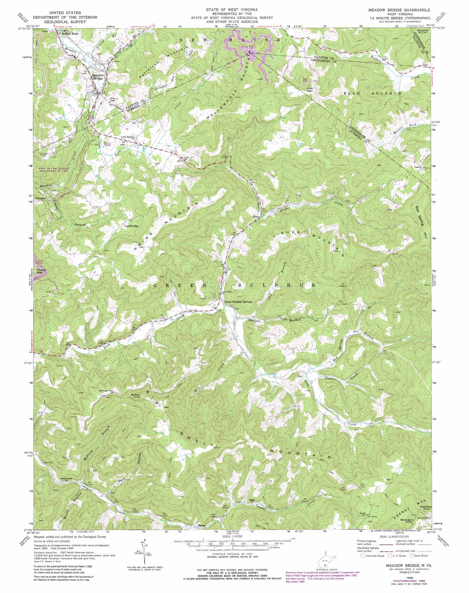
Meadow Bridge Topo Map West Virginia
To zoom in, hover over the map of Meadow Bridge
USGS Topo Quad 37080g7 - 1:24,000 scale
| Topo Map Name: | Meadow Bridge |
| USGS Topo Quad ID: | 37080g7 |
| Print Size: | ca. 21 1/4" wide x 27" high |
| Southeast Coordinates: | 37.75° N latitude / 80.75° W longitude |
| Map Center Coordinates: | 37.8125° N latitude / 80.8125° W longitude |
| U.S. State: | WV |
| Filename: | o37080g7.jpg |
| Download Map JPG Image: | Meadow Bridge topo map 1:24,000 scale |
| Map Type: | Topographic |
| Topo Series: | 7.5´ |
| Map Scale: | 1:24,000 |
| Source of Map Images: | United States Geological Survey (USGS) |
| Alternate Map Versions: |
Meadow Bridge WV 1969, updated 1974 Download PDF Buy paper map Meadow Bridge WV 1969, updated 1977 Download PDF Buy paper map Meadow Bridge WV 1969, updated 1989 Download PDF Buy paper map Meadow Bridge WV 2011 Download PDF Buy paper map Meadow Bridge WV 2014 Download PDF Buy paper map Meadow Bridge WV 2016 Download PDF Buy paper map |
1:24,000 Topo Quads surrounding Meadow Bridge
Fayetteville |
Winona |
Corliss |
Quinwood |
Duo |
Thurmond |
Danese |
Rainelle |
Rupert |
Cornstalk |
Prince |
Meadow Creek |
Meadow Bridge |
Dawson |
Asbury |
Shady Spring |
Hinton |
Talcott |
Alderson |
Fort Spring |
Flat Top |
Pipestem |
Forest Hill |
Greenville |
Union |
> Back to 37080e1 at 1:100,000 scale
> Back to 37080a1 at 1:250,000 scale
> Back to U.S. Topo Maps home
Meadow Bridge topo map: Gazetteer
Meadow Bridge: Crossings
Interchange 143 elevation 472m 1548′Meadow Bridge: Populated Places
Beelick Knob elevation 744m 2440′Claypool elevation 582m 1909′
Elton elevation 533m 1748′
Green Sulphur Springs elevation 474m 1555′
Lawn elevation 801m 2627′
Lockbridge elevation 753m 2470′
Meadow Bridge elevation 741m 2431′
Ramp elevation 537m 1761′
Tina (historical) elevation 590m 1935′
Meadow Bridge: Post Offices
Elton Post Office elevation 528m 1732′Green Sulphur Springs Post Office elevation 479m 1571′
Lockbridge Post Office elevation 767m 2516′
Meadow Bridge: Springs
Green Sulphur Spring elevation 491m 1610′James Harless Spring elevation 665m 2181′
Meadow Bridge: Streams
Claypool Branch elevation 546m 1791′Coon Creek elevation 663m 2175′
Cox Branch elevation 486m 1594′
Duncan Branch elevation 473m 1551′
Fisher Creek elevation 536m 1758′
Laurel Branch elevation 740m 2427′
Lively Branch elevation 741m 2431′
Mill Creek elevation 469m 1538′
Miller Creek elevation 484m 1587′
Mudlick Branch elevation 468m 1535′
Red Spring Branch elevation 513m 1683′
Slater Creek elevation 513m 1683′
Willis Branch elevation 469m 1538′
Meadow Bridge: Summits
Big Swell Mountain elevation 978m 3208′Buffalo Knob elevation 919m 3015′
Fisher Mountain elevation 968m 3175′
Gwinn Mountain elevation 899m 2949′
Irish Mountain elevation 1010m 3313′
Patterson Mountain elevation 953m 3126′
Swell Mountain elevation 978m 3208′
Wallowhole Mountain elevation 998m 3274′
Meadow Bridge: Valleys
Dark Hollow elevation 488m 1601′Meadow Bridge digital topo map on disk
Buy this Meadow Bridge topo map showing relief, roads, GPS coordinates and other geographical features, as a high-resolution digital map file on DVD:
Western Virginia & Southern West Virginia
Buy digital topo maps: Western Virginia & Southern West Virginia