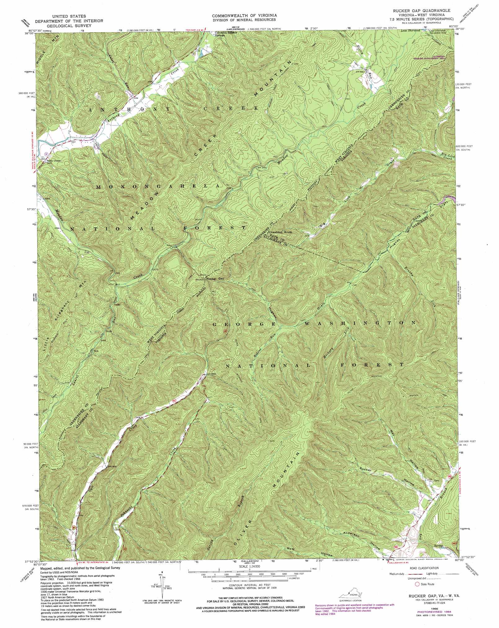
Rucker Gap Topo Map Virginia
To zoom in, hover over the map of Rucker Gap
USGS Topo Quad 37080h1 - 1:24,000 scale
| Topo Map Name: | Rucker Gap |
| USGS Topo Quad ID: | 37080h1 |
| Print Size: | ca. 21 1/4" wide x 27" high |
| Southeast Coordinates: | 37.875° N latitude / 80° W longitude |
| Map Center Coordinates: | 37.9375° N latitude / 80.0625° W longitude |
| U.S. States: | VA, WV |
| Filename: | o37080h1.jpg |
| Download Map JPG Image: | Rucker Gap topo map 1:24,000 scale |
| Map Type: | Topographic |
| Topo Series: | 7.5´ |
| Map Scale: | 1:24,000 |
| Source of Map Images: | United States Geological Survey (USGS) |
| Alternate Map Versions: |
Rucker Gap VA 1966, updated 1968 Download PDF Buy paper map Rucker Gap VA 1966, updated 1984 Download PDF Buy paper map Rucker Gap VA 1995, updated 1998 Download PDF Buy paper map Rucker Gap VA 2011 Download PDF Buy paper map Rucker Gap VA 2013 Download PDF Buy paper map Rucker Gap VA 2016 Download PDF Buy paper map |
| FStopo: | US Forest Service topo Rucker Gap is available: Download FStopo PDF Download FStopo TIF |
1:24,000 Topo Quads surrounding Rucker Gap
Lobelia |
Hillsboro |
Marlinton |
Minnehaha Springs |
Sunrise |
Droop |
Denmar |
Lake Sherwood |
Mountain Grove |
Warm Springs |
Anthony |
Alvon |
Rucker Gap |
Falling Spring |
Healing Springs |
White Sulphur Springs |
Jerrys Run |
Callaghan |
Covington |
Clifton Forge |
Glace |
Alleghany |
Jordan Mines |
Strom |
Eagle Rock |
> Back to 37080e1 at 1:100,000 scale
> Back to 37080a1 at 1:250,000 scale
> Back to U.S. Topo Maps home
Rucker Gap topo map: Gazetteer
Rucker Gap: Gaps
Rucker Gap elevation 794m 2604′Rucker Gap: Streams
Brushy Lick elevation 499m 1637′Coles Run elevation 635m 2083′
Hickory Lick elevation 534m 1751′
Laurel Run elevation 673m 2208′
Pond Lick Run elevation 648m 2125′
Robins Run elevation 572m 1876′
Rucker Gap: Summits
Chestnut Knob elevation 977m 3205′Chestnut Knob elevation 978m 3208′
Oliver Mountain elevation 1088m 3569′
Rucker Gap: Trails
Allegheny Mountain Trail elevation 876m 2874′Allegheny Mountain Trail elevation 891m 2923′
Diley Trail elevation 804m 2637′
Jackson Trail elevation 726m 2381′
Lake Sherwood Trail elevation 842m 2762′
Oliver Mountain Trail elevation 917m 3008′
Rucker Gap: Valleys
May Hollow elevation 501m 1643′Rucker Hollow elevation 500m 1640′
Rucker Gap digital topo map on disk
Buy this Rucker Gap topo map showing relief, roads, GPS coordinates and other geographical features, as a high-resolution digital map file on DVD:
Western Virginia & Southern West Virginia
Buy digital topo maps: Western Virginia & Southern West Virginia