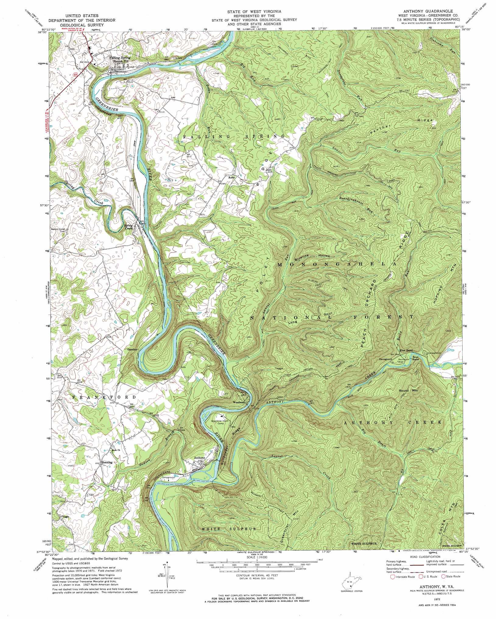
Anthony Topo Map West Virginia
To zoom in, hover over the map of Anthony
USGS Topo Quad 37080h3 - 1:24,000 scale
| Topo Map Name: | Anthony |
| USGS Topo Quad ID: | 37080h3 |
| Print Size: | ca. 21 1/4" wide x 27" high |
| Southeast Coordinates: | 37.875° N latitude / 80.25° W longitude |
| Map Center Coordinates: | 37.9375° N latitude / 80.3125° W longitude |
| U.S. State: | WV |
| Filename: | o37080h3.jpg |
| Download Map JPG Image: | Anthony topo map 1:24,000 scale |
| Map Type: | Topographic |
| Topo Series: | 7.5´ |
| Map Scale: | 1:24,000 |
| Source of Map Images: | United States Geological Survey (USGS) |
| Alternate Map Versions: |
Anthony WV 1972, updated 1974 Download PDF Buy paper map Anthony WV 1995, updated 1998 Download PDF Buy paper map Anthony WV 2011 Download PDF Buy paper map Anthony WV 2014 Download PDF Buy paper map Anthony WV 2016 Download PDF Buy paper map |
| FStopo: | US Forest Service topo Anthony is available: Download FStopo PDF Download FStopo TIF |
1:24,000 Topo Quads surrounding Anthony
Richwood |
Fork Mountain |
Lobelia |
Hillsboro |
Marlinton |
Duo |
Trout |
Droop |
Denmar |
Lake Sherwood |
Cornstalk |
Williamsburg |
Anthony |
Alvon |
Rucker Gap |
Asbury |
Lewisburg |
White Sulphur Springs |
Jerrys Run |
Callaghan |
Fort Spring |
Ronceverte |
Glace |
Alleghany |
Jordan Mines |
> Back to 37080e1 at 1:100,000 scale
> Back to 37080a1 at 1:250,000 scale
> Back to U.S. Topo Maps home
Anthony topo map: Gazetteer
Anthony: Bends
Blue Bend elevation 585m 1919′Anthony: Populated Places
Anthony elevation 563m 1847′Blue Bend elevation 594m 1948′
Falling Spring elevation 587m 1925′
Gardner elevation 563m 1847′
Henning elevation 681m 2234′
Spring Creek elevation 577m 1893′
Vago elevation 709m 2326′
Woodman elevation 560m 1837′
Anthony: Post Offices
Anthony Post Office elevation 561m 1840′Auto Post Office elevation 713m 2339′
Anthony: Ridges
Gunpowder Ridge elevation 673m 2208′Long Spur elevation 821m 2693′
Panther Ridge elevation 912m 2992′
Peach Orchard Ridge elevation 916m 3005′
Poley Ridge elevation 761m 2496′
Anthony: Springs
Burns Cave Number 2 Spring elevation 579m 1899′Anthony: Streams
Anthony Creek elevation 545m 1788′Big Run elevation 571m 1873′
Boardinghouse Run elevation 687m 2253′
Boardinghouse Run elevation 664m 2178′
Boggs Run elevation 571m 1873′
Dodson Branch elevation 543m 1781′
Laurel Creek elevation 552m 1811′
Laurel Run elevation 552m 1811′
Red Run elevation 718m 2355′
Rocky Run elevation 581m 1906′
Spring Creek elevation 562m 1843′
Anthony: Summits
Hopkins Mountain elevation 1002m 3287′Round Mountain elevation 875m 2870′
Anthony: Trails
Big Run Trail elevation 697m 2286′Blue Bend Loop Trail elevation 786m 2578′
Blueline Trail elevation 830m 2723′
Civil War Trail elevation 870m 2854′
Coles Mountain Trail elevation 908m 2979′
Greenbrier River Trail elevation 714m 2342′
Laurel Run Trail elevation 640m 2099′
Peach Orchard Trail elevation 887m 2910′
South Boundary Trail elevation 870m 2854′
Anthony: Valleys
Big Draft elevation 574m 1883′Blueline Hollow elevation 618m 2027′
Anthony digital topo map on disk
Buy this Anthony topo map showing relief, roads, GPS coordinates and other geographical features, as a high-resolution digital map file on DVD:
Western Virginia & Southern West Virginia
Buy digital topo maps: Western Virginia & Southern West Virginia