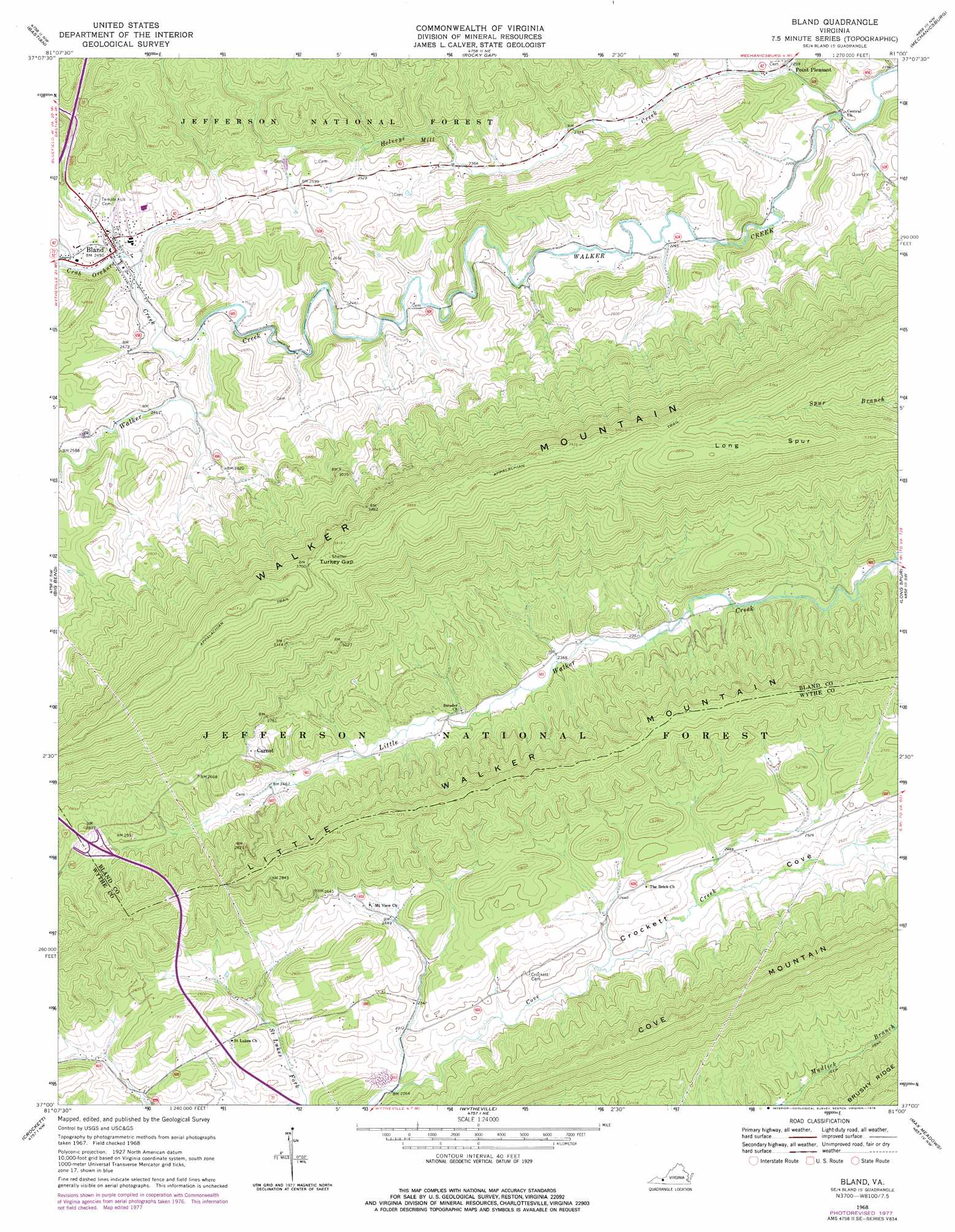
Bland Topo Map Virginia
To zoom in, hover over the map of Bland
USGS Topo Quad 37081a1 - 1:24,000 scale
| Topo Map Name: | Bland |
| USGS Topo Quad ID: | 37081a1 |
| Print Size: | ca. 21 1/4" wide x 27" high |
| Southeast Coordinates: | 37° N latitude / 81° W longitude |
| Map Center Coordinates: | 37.0625° N latitude / 81.0625° W longitude |
| U.S. State: | VA |
| Filename: | o37081a1.jpg |
| Download Map JPG Image: | Bland topo map 1:24,000 scale |
| Map Type: | Topographic |
| Topo Series: | 7.5´ |
| Map Scale: | 1:24,000 |
| Source of Map Images: | United States Geological Survey (USGS) |
| Alternate Map Versions: |
Bland VA 1968, updated 1971 Download PDF Buy paper map Bland VA 1968, updated 1978 Download PDF Buy paper map Bland VA 1968, updated 1978 Download PDF Buy paper map Bland VA 2011 Download PDF Buy paper map Bland VA 2013 Download PDF Buy paper map Bland VA 2016 Download PDF Buy paper map |
| FStopo: | US Forest Service topo Bland is available: Download FStopo PDF Download FStopo TIF |
1:24,000 Topo Quads surrounding Bland
Bramwell |
Bluefield |
Princeton |
Oakvale |
Narrows |
Cove Creek |
Bastian |
Rocky Gap |
Mechanicsburg |
White Gate |
Garden Mountain |
Big Bend |
Bland |
Long Spur |
Pulaski |
Rural Retreat |
Crockett |
Wytheville |
Max Meadows |
Fosters Falls |
Cedar Springs |
Speedwell |
Cripple Creek |
Austinville |
Sylvatus |
> Back to 37081a1 at 1:100,000 scale
> Back to 37080a1 at 1:250,000 scale
> Back to U.S. Topo Maps home
Bland topo map: Gazetteer
Bland: Areas
The Flatwoods elevation 812m 2664′Bland: Crossings
Interchange 47 elevation 802m 2631′Bland: Gaps
Turkey Gap elevation 1124m 3687′Bland: Populated Places
Bland elevation 743m 2437′Carnot elevation 797m 2614′
Point Pleasant elevation 686m 2250′
Bland: Ridges
Town Ridge elevation 843m 2765′Bland: Streams
Bob King Branch elevation 718m 2355′Church Branch elevation 731m 2398′
Crab Orchard Creek elevation 737m 2417′
Creed Branch elevation 740m 2427′
Helveys Mill Creek elevation 671m 2201′
Polly Branch elevation 728m 2388′
Poplar Spring Branch elevation 747m 2450′
Surrat Branch elevation 736m 2414′
Town Creek elevation 747m 2450′
Waterfall Branch elevation 707m 2319′
Bland: Summits
Little Walker Mountain elevation 977m 3205′Bland: Valleys
Crockett Cove elevation 716m 2349′Bland digital topo map on disk
Buy this Bland topo map showing relief, roads, GPS coordinates and other geographical features, as a high-resolution digital map file on DVD:
Western Virginia & Southern West Virginia
Buy digital topo maps: Western Virginia & Southern West Virginia