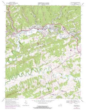
Richlands Topo Map Virginia
To zoom in, hover over the map of Richlands
USGS Topo Quad 37081a7 - 1:24,000 scale
| Topo Map Name: | Richlands |
| USGS Topo Quad ID: | 37081a7 |
| Print Size: | ca. 21 1/4" wide x 27" high |
| Southeast Coordinates: | 37° N latitude / 81.75° W longitude |
| Map Center Coordinates: | 37.0625° N latitude / 81.8125° W longitude |
| U.S. State: | VA |
| Filename: | o37081a7.jpg |
| Download Map JPG Image: | Richlands topo map 1:24,000 scale |
| Map Type: | Topographic |
| Topo Series: | 7.5´ |
| Map Scale: | 1:24,000 |
| Source of Map Images: | United States Geological Survey (USGS) |
| Alternate Map Versions: |
Richlands VA 1935 Download PDF Buy paper map Richlands VA 1947, updated 1965 Download PDF Buy paper map Richlands VA 1968, updated 1972 Download PDF Buy paper map Richlands VA 1968, updated 1978 Download PDF Buy paper map Richlands VA 2010 Download PDF Buy paper map Richlands VA 2013 Download PDF Buy paper map Richlands VA 2016 Download PDF Buy paper map |
1:24,000 Topo Quads surrounding Richlands
> Back to 37081a1 at 1:100,000 scale
> Back to 37080a1 at 1:250,000 scale
> Back to U.S. Topo Maps home
Richlands topo map: Gazetteer
Richlands: Airports
Humana Hospital-Clinch Valley Heliport elevation 589m 1932′Richlands Municipal Airport (historical) elevation 582m 1909′
Tazewell County Airport elevation 794m 2604′
Richlands: Cliffs
Cedar Bluff elevation 693m 2273′Richlands: Gaps
Asbury Gap elevation 786m 2578′Richlands: Mines
Field-Scott Mines elevation 673m 2208′Richlands: Populated Places
Birmingham elevation 629m 2063′Cedar Bluff elevation 598m 1961′
Claypool Hill elevation 716m 2349′
Clifton elevation 628m 2060′
Dalton Addition elevation 605m 1984′
Daw elevation 575m 1886′
Doran elevation 585m 1919′
Indian elevation 601m 1971′
Lake Park elevation 592m 1942′
Paintlick elevation 668m 2191′
Premier elevation 672m 2204′
Raven elevation 583m 1912′
Red Ash elevation 662m 2171′
Richlands elevation 589m 1932′
Steeleburg elevation 691m 2267′
Wardell elevation 628m 2060′
West Raven elevation 587m 1925′
Richlands: Post Offices
Richlands Post Office elevation 592m 1942′Richlands: Ridges
Kents Ridge elevation 815m 2673′Middle Creek Ridge elevation 824m 2703′
Stony Ridge elevation 824m 2703′
West Fork Ridge elevation 842m 2762′
Richlands: Streams
Big Creek elevation 583m 1912′Coal Creek elevation 589m 1932′
Dry Branch elevation 598m 1961′
Grays Branch elevation 625m 2050′
Indian Creek elevation 592m 1942′
Indian Creek elevation 625m 2050′
Jessie Branch elevation 627m 2057′
Katie Branch elevation 628m 2060′
Laurel Creek elevation 637m 2089′
Left Fork Coal Creek elevation 678m 2224′
Left Fork Indian Creek elevation 661m 2168′
Little Mill Creek elevation 591m 1938′
Little Town Hill Creek elevation 584m 1916′
Long Branch elevation 588m 1929′
McCoy Branch elevation 614m 2014′
Middle Creek elevation 597m 1958′
Mill Creek elevation 585m 1919′
Millstone Branch elevation 624m 2047′
Mudlick Creek elevation 584m 1916′
Smith Branch elevation 631m 2070′
Sugar Run elevation 577m 1893′
Town Hill Creek elevation 589m 1932′
West Fork Big Creek elevation 632m 2073′
Zeke Creek elevation 675m 2214′
Richlands: Summits
Claypool Hill elevation 745m 2444′Richlands: Valleys
Brown Hollow elevation 627m 2057′Brown Hollow elevation 642m 2106′
Doughton Hollow elevation 625m 2050′
East Town Hollow elevation 656m 2152′
Gillespie Hollow elevation 604m 1981′
Kentucky Hollow elevation 652m 2139′
Malory Hollow elevation 636m 2086′
Millstone Hollow elevation 587m 1925′
Piney Spring Hollow elevation 661m 2168′
Rich Long Hollow elevation 609m 1998′
Sulphur Spring Hollow elevation 619m 2030′
Town Hollow elevation 653m 2142′
Whites Hollow elevation 660m 2165′
Wood Hollow elevation 647m 2122′
Richlands digital topo map on disk
Buy this Richlands topo map showing relief, roads, GPS coordinates and other geographical features, as a high-resolution digital map file on DVD:
Western Virginia & Southern West Virginia
Buy digital topo maps: Western Virginia & Southern West Virginia


