Jewell Ridge Topo Map Virginia
To zoom in, hover over the map of Jewell Ridge
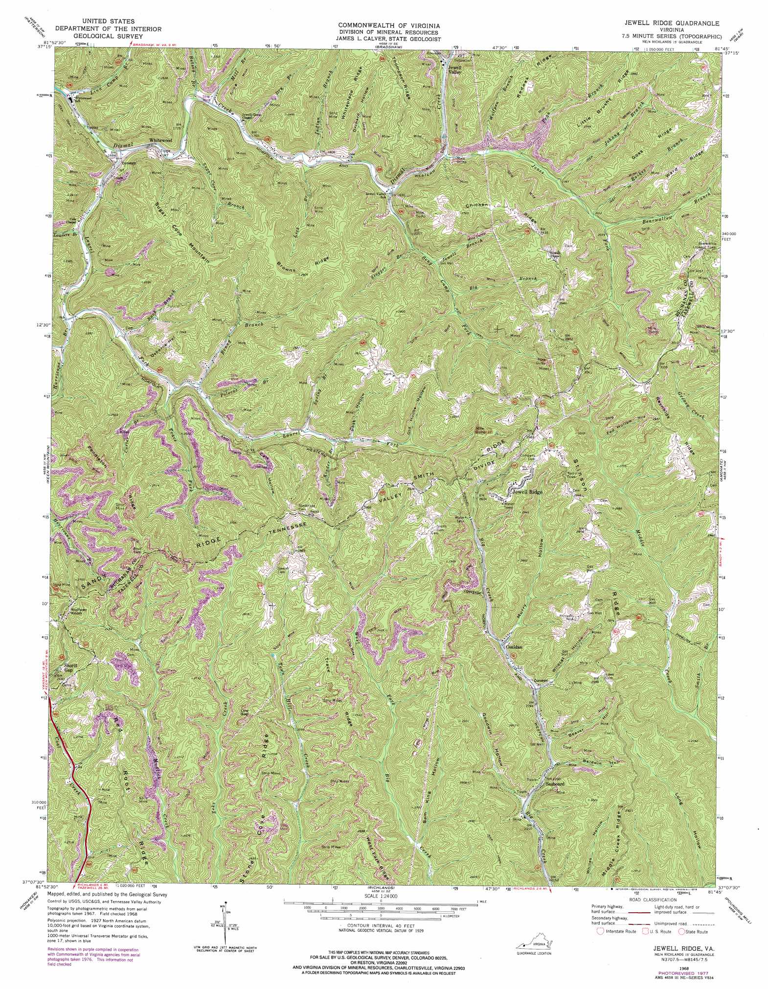
USGS Topo Quad 37081b7 - 1:24,000 scale
| Topo Map Name: | Jewell Ridge |
| USGS Topo Quad ID: | 37081b7 |
| Print Size: | ca. 21 1/4" wide x 27" high |
| Southeast Coordinates: | 37.125° N latitude / 81.75° W longitude |
| Map Center Coordinates: | 37.1875° N latitude / 81.8125° W longitude |
| U.S. State: | VA |
| Filename: | o37081b7.jpg |
| Download Map JPG Image: | Jewell Ridge topo map 1:24,000 scale |
| Map Type: | Topographic |
| Topo Series: | 7.5´ |
| Map Scale: | 1:24,000 |
| Source of Map Images: | United States Geological Survey (USGS) |
| Alternate Map Versions: |
Jewell VA 1935 Download PDF Buy paper map Jewell Ridge VA 1968, updated 1972 Download PDF Buy paper map Jewell Ridge VA 1968, updated 1978 Download PDF Buy paper map Jewell Ridge VA 2010 Download PDF Buy paper map Jewell Ridge VA 2013 Download PDF Buy paper map Jewell Ridge VA 2016 Download PDF Buy paper map |
1:24,000 Topo Quads surrounding Jewell Ridge
Hurley |
Panther |
Iaeger |
Davy |
Welch |
Grundy |
Patterson |
Bradshaw |
War |
Gary |
Vansant |
Keen Mountain |
Jewell Ridge |
Amonate |
Tazewell North |
Big A Mountain |
Honaker |
Richlands |
Pounding Mill |
Tazewell South |
Lebanon |
Elk Garden |
Saltville |
Broadford |
Chatham Hill |
> Back to 37081a1 at 1:100,000 scale
> Back to 37080a1 at 1:250,000 scale
> Back to U.S. Topo Maps home
Jewell Ridge topo map: Gazetteer
Jewell Ridge: Gaps
Hickory Gap elevation 832m 2729′Low Gap elevation 836m 2742′
Jewell Ridge: Populated Places
Afredton elevation 668m 2191′Coaldan elevation 703m 2306′
Glen Burke elevation 726m 2381′
Jewell Ridge elevation 905m 2969′
Jewell Valley elevation 575m 1886′
Seaboard elevation 682m 2237′
Shortt Gap elevation 739m 2424′
Sulphur Spring (historical) elevation 655m 2148′
Whitewood elevation 512m 1679′
Jewell Ridge: Ridges
Bear Pin Ridge elevation 830m 2723′Browns Ridge elevation 878m 2880′
Chicken Ridge elevation 850m 2788′
Goss Ridge elevation 867m 2844′
Little Brushy Ridge elevation 838m 2749′
Pendleton Ridge elevation 853m 2798′
Red Root Ridge elevation 838m 2749′
Reynolds Ridge elevation 886m 2906′
Smith Ridge elevation 865m 2837′
Stinson Ridge elevation 862m 2828′
Stone Cove Ridge elevation 844m 2769′
Thompson Ridge elevation 843m 2765′
Trace Ridge elevation 888m 2913′
Ward Ridge elevation 878m 2880′
Whiteplace Ridge elevation 801m 2627′
Jewell Ridge: Streams
Bearwallow Branch elevation 615m 2017′Benny Branch elevation 558m 1830′
Betsey Branch elevation 521m 1709′
Big Branch elevation 603m 1978′
Brushytop Fork elevation 575m 1886′
Buck Branch elevation 547m 1794′
Carter Branch elevation 566m 1856′
Dry Branch elevation 529m 1735′
Hurricane Branch elevation 540m 1771′
Indian Branch elevation 543m 1781′
Jewell Branch elevation 591m 1938′
Jones Fork elevation 565m 1853′
Kinder Branch elevation 605m 1984′
Lauders Branch elevation 522m 1712′
Laurel Fork elevation 508m 1666′
Lick Branch elevation 544m 1784′
Linn Camp Branch elevation 496m 1627′
Little Hurricane Branch elevation 547m 1794′
Long Branch elevation 666m 2185′
Mill Branch elevation 526m 1725′
Peak Branch elevation 581m 1906′
Polecat Branch elevation 563m 1847′
Raikes Branch elevation 613m 2011′
Seng Camp Fork elevation 555m 1820′
Smith Branch elevation 698m 2290′
Spring Branch elevation 598m 1961′
Stagger Branch elevation 578m 1896′
Sugar Cove Branch elevation 517m 1696′
Trace Fork elevation 553m 1814′
Wolfpen Branch elevation 576m 1889′
Jewell Ridge: Summits
Sugar Cove Mountain elevation 885m 2903′Wolfpen Knob elevation 860m 2821′
Jewell Ridge: Valleys
Baldwin Hollow elevation 692m 2270′Beaver Hollow elevation 686m 2250′
Calf Hollow elevation 584m 1916′
Carpet Hollow elevation 702m 2303′
Chicken Coop Hollow elevation 726m 2381′
Fed Hollow elevation 761m 2496′
Goodwin Hollow elevation 674m 2211′
Goss Hollow elevation 614m 2014′
Long Hollow elevation 666m 2185′
Muddy Hollow elevation 721m 2365′
Murry Hollow elevation 700m 2296′
Old House Hollow elevation 652m 2139′
Orchard Hollow elevation 548m 1797′
Osborne Hollow elevation 551m 1807′
Sam King Hollow elevation 689m 2260′
Wildcat Hollow elevation 701m 2299′
Jewell Ridge digital topo map on disk
Buy this Jewell Ridge topo map showing relief, roads, GPS coordinates and other geographical features, as a high-resolution digital map file on DVD:
Western Virginia & Southern West Virginia
Buy digital topo maps: Western Virginia & Southern West Virginia