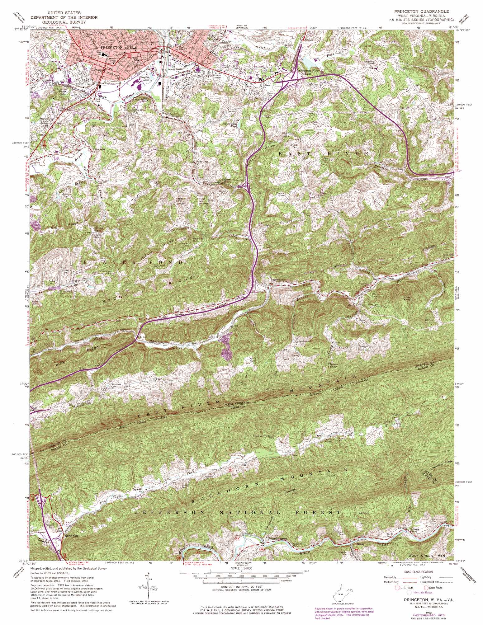
Princeton Topo Map West Virginia
To zoom in, hover over the map of Princeton
USGS Topo Quad 37081c1 - 1:24,000 scale
| Topo Map Name: | Princeton |
| USGS Topo Quad ID: | 37081c1 |
| Print Size: | ca. 21 1/4" wide x 27" high |
| Southeast Coordinates: | 37.25° N latitude / 81° W longitude |
| Map Center Coordinates: | 37.3125° N latitude / 81.0625° W longitude |
| U.S. States: | WV, VA |
| Filename: | o37081c1.jpg |
| Download Map JPG Image: | Princeton topo map 1:24,000 scale |
| Map Type: | Topographic |
| Topo Series: | 7.5´ |
| Map Scale: | 1:24,000 |
| Source of Map Images: | United States Geological Survey (USGS) |
| Alternate Map Versions: |
Princeton WV 1962, updated 1963 Download PDF Buy paper map Princeton WV 1962, updated 1974 Download PDF Buy paper map Princeton WV 1962, updated 1978 Download PDF Buy paper map Princeton WV 2011 Download PDF Buy paper map Princeton WV 2014 Download PDF Buy paper map Princeton WV 2016 Download PDF Buy paper map |
| FStopo: | US Forest Service topo Princeton is available: Download FStopo PDF Download FStopo TIF |
1:24,000 Topo Quads surrounding Princeton
Rhodell |
Odd |
Flat Top |
Pipestem |
Forest Hill |
Crumpler |
Matoaka |
Athens |
Lerona |
Peterstown |
Bramwell |
Bluefield |
Princeton |
Oakvale |
Narrows |
Cove Creek |
Bastian |
Rocky Gap |
Mechanicsburg |
White Gate |
Garden Mountain |
Big Bend |
Bland |
Long Spur |
Pulaski |
> Back to 37081a1 at 1:100,000 scale
> Back to 37080a1 at 1:250,000 scale
> Back to U.S. Topo Maps home
Princeton topo map: Gazetteer
Princeton: Airports
Princeton Community Hospital Heliport elevation 732m 2401′Princeton: Crossings
Interchange 5 elevation 618m 2027′Interchange 66 elevation 727m 2385′
Interchange 7 elevation 677m 2221′
Interchange 9 elevation 782m 2565′
Princeton: Dams
Brush Creek Structure Number 10 Dam elevation 564m 1850′Daves Fork-Christians Fork Structure Three Dam elevation 744m 2440′
Princeton: Flats
Stumpy Bottom elevation 729m 2391′Princeton: Gaps
Oney Gap elevation 781m 2562′Princeton: Lakes
Douglas Lake elevation 728m 2388′Simon Fish Pond elevation 786m 2578′
Princeton: Parks
Princeton Youth Park elevation 747m 2450′Princeton: Populated Places
Billie (historical) elevation 757m 2483′Blake (historical) elevation 614m 2014′
East River (historical) elevation 563m 1847′
Hardy elevation 589m 1932′
Ingleside elevation 589m 1932′
Lilly Grove elevation 742m 2434′
Niday elevation 577m 1893′
North Gap elevation 635m 2083′
Princeton elevation 742m 2434′
Round Bottom elevation 589m 1932′
Princeton: Post Offices
Princeton Post Office elevation 746m 2447′Princeton: Reservoirs
Christian Fork Lake elevation 746m 2447′Princeton: Ridges
Big Ridge elevation 849m 2785′East River Mountain elevation 1050m 3444′
Middle Ridge elevation 792m 2598′
Pine Ridge elevation 778m 2552′
Princeton: Springs
Birchfield Spring elevation 598m 1961′Jarrell Spring elevation 703m 2306′
Thomas Spring elevation 778m 2552′
Princeton: Streams
Big Spring Branch elevation 632m 2073′Bratton Branch elevation 729m 2391′
Christian Fork elevation 731m 2398′
Daves Fork elevation 726m 2381′
Dry Fork elevation 635m 2083′
Glady Fork elevation 726m 2381′
Gracie Branch elevation 578m 1896′
Harmon Branch elevation 561m 1840′
Mill Branch elevation 572m 1876′
Peggy Branch elevation 570m 1870′
Twelvemile Creek elevation 594m 1948′
Willow Brook elevation 729m 2391′
Princeton: Summits
Tater Knob elevation 699m 2293′Princeton: Tunnels
East River Mountain Tunnel elevation 1087m 3566′East River Mountain Tunnel elevation 1020m 3346′
Princeton: Valleys
Hoot Owl Hollow elevation 559m 1833′Lambert Hollow elevation 576m 1889′
Mills Valley elevation 656m 2152′
Opossum Hollow elevation 586m 1922′
Rocky Hollow elevation 676m 2217′
Spangler Valley elevation 601m 1971′
Princeton digital topo map on disk
Buy this Princeton topo map showing relief, roads, GPS coordinates and other geographical features, as a high-resolution digital map file on DVD:
Western Virginia & Southern West Virginia
Buy digital topo maps: Western Virginia & Southern West Virginia