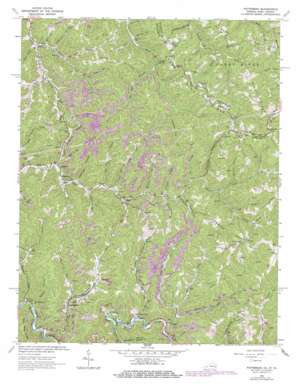
Patterson Topo Map Virginia
To zoom in, hover over the map of Patterson
USGS Topo Quad 37081c8 - 1:24,000 scale
| Topo Map Name: | Patterson |
| USGS Topo Quad ID: | 37081c8 |
| Print Size: | ca. 21 1/4" wide x 27" high |
| Southeast Coordinates: | 37.25° N latitude / 81.875° W longitude |
| Map Center Coordinates: | 37.3125° N latitude / 81.9375° W longitude |
| U.S. States: | VA, WV |
| Filename: | o37081c8.jpg |
| Download Map JPG Image: | Patterson topo map 1:24,000 scale |
| Map Type: | Topographic |
| Topo Series: | 7.5´ |
| Map Scale: | 1:24,000 |
| Source of Map Images: | United States Geological Survey (USGS) |
| Alternate Map Versions: |
Patterson VA 1964, updated 1965 Download PDF Buy paper map Patterson VA 1964, updated 1975 Download PDF Buy paper map Patterson VA 1964, updated 1978 Download PDF Buy paper map Patterson VA 2011 Download PDF Buy paper map Patterson VA 2013 Download PDF Buy paper map Patterson VA 2016 Download PDF Buy paper map |
1:24,000 Topo Quads surrounding Patterson
> Back to 37081a1 at 1:100,000 scale
> Back to 37080a1 at 1:250,000 scale
> Back to U.S. Topo Maps home
Patterson topo map: Gazetteer
Patterson: Populated Places
Dwight elevation 474m 1555′Hale Creek elevation 468m 1535′
Jackson Flats elevation 703m 2306′
Matney elevation 430m 1410′
Patterson elevation 460m 1509′
Paynesville elevation 715m 2345′
Paynesville elevation 712m 2335′
Slate elevation 465m 1525′
Stacy elevation 427m 1400′
Wolford elevation 364m 1194′
Patterson: Ridges
Baker Ridge elevation 630m 2066′Bend Spur Ridge elevation 713m 2339′
Brushy Ridge elevation 674m 2211′
State Line Ridge elevation 612m 2007′
State Line Ridge elevation 644m 2112′
Patterson: Streams
Bee Branch elevation 498m 1633′Bee Run elevation 449m 1473′
Big Butt Branch elevation 443m 1453′
Blackey Fork elevation 363m 1190′
Blackey Fork elevation 559m 1833′
Board Camp Branch elevation 361m 1184′
Charles Fork elevation 398m 1305′
Christian Camp Branch elevation 461m 1512′
Coon Branch elevation 411m 1348′
Cub Branch elevation 519m 1702′
Dan Branch elevation 420m 1377′
Deep Branch elevation 447m 1466′
Dry Tripe Branch elevation 456m 1496′
Farlow Branch elevation 429m 1407′
Hale Creek elevation 460m 1509′
Horseshoe Branch elevation 443m 1453′
Hulen Branch elevation 381m 1250′
Hurricane Fork elevation 448m 1469′
Ives Branch elevation 440m 1443′
Johns Branch elevation 405m 1328′
Kennedy Branch elevation 523m 1715′
Larken Branch elevation 432m 1417′
Left Fork Long Branch elevation 474m 1555′
Left Fork Middle Fork Spruce Pine Creek elevation 585m 1919′
Left Fork Slate Creek elevation 510m 1673′
Long Branch elevation 406m 1332′
Lower Big Branch elevation 384m 1259′
Meetinghouse Branch elevation 466m 1528′
Middle Fork Spruce Pine Creek elevation 482m 1581′
Midway Branch elevation 387m 1269′
Nighway Branch elevation 502m 1646′
Old Camp Branch elevation 462m 1515′
Orchard Branch elevation 479m 1571′
Orchard Fork elevation 490m 1607′
Payne Branch elevation 458m 1502′
Smith Branch elevation 413m 1354′
South Fork Slaunch Fork elevation 455m 1492′
Spruce Pine Creek elevation 469m 1538′
Squire Branch elevation 442m 1450′
Stiltner Branch elevation 478m 1568′
Stonecoal Branch elevation 346m 1135′
Taylor Fork elevation 479m 1571′
Toms Branch elevation 413m 1354′
Twin Branch elevation 439m 1440′
Upper Rockhouse Branch elevation 432m 1417′
Wolfpen Branch elevation 481m 1578′
Woosley Branch elevation 474m 1555′
Patterson: Summits
Bradshaw Mountain elevation 714m 2342′Patterson: Valleys
Chestnut Hollow elevation 462m 1515′Pressley Hollow elevation 445m 1459′
Tig Hollow elevation 384m 1259′
Trace Hollow elevation 485m 1591′
Patterson digital topo map on disk
Buy this Patterson topo map showing relief, roads, GPS coordinates and other geographical features, as a high-resolution digital map file on DVD:
Western Virginia & Southern West Virginia
Buy digital topo maps: Western Virginia & Southern West Virginia


