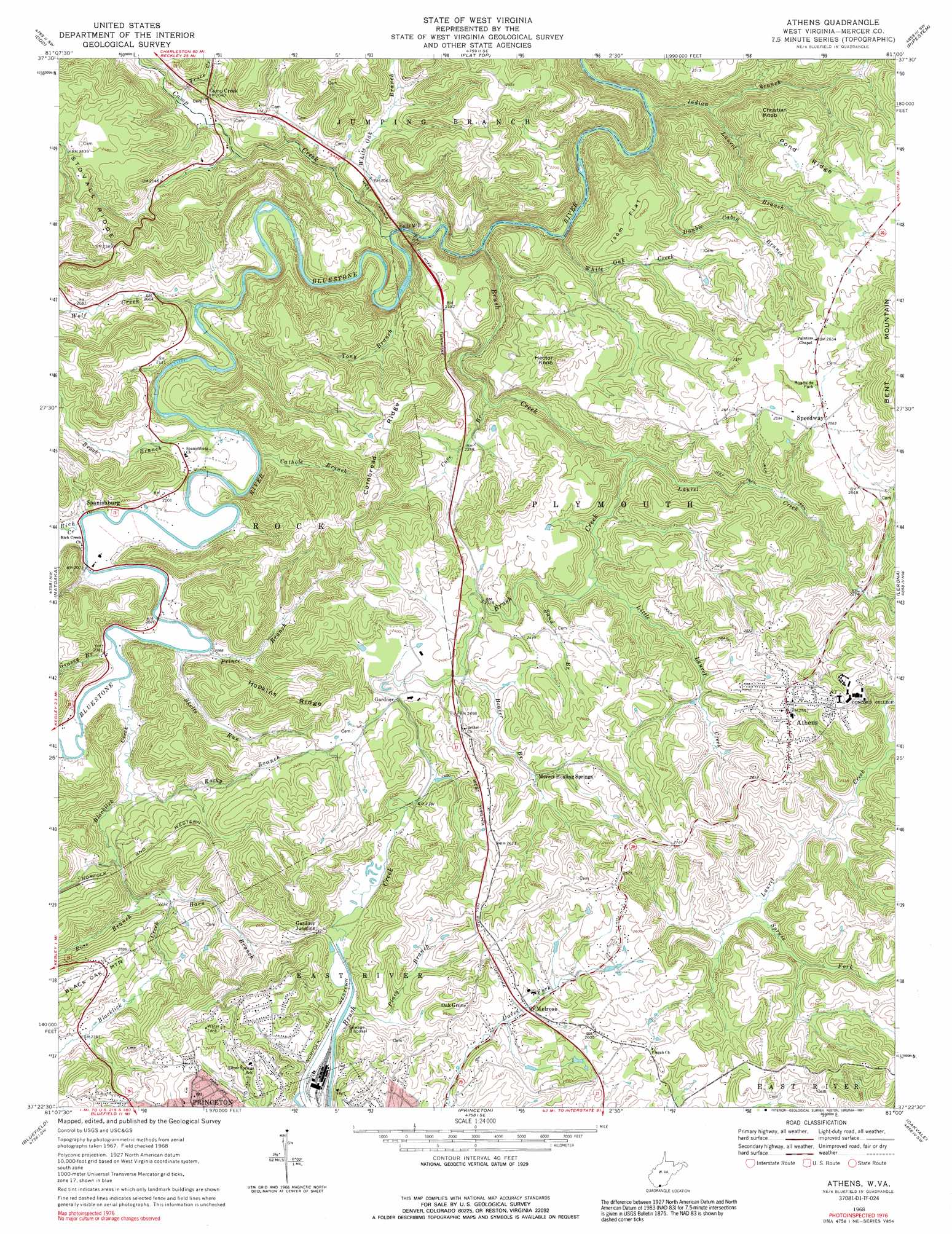
Athens Topo Map West Virginia
To zoom in, hover over the map of Athens
USGS Topo Quad 37081d1 - 1:24,000 scale
| Topo Map Name: | Athens |
| USGS Topo Quad ID: | 37081d1 |
| Print Size: | ca. 21 1/4" wide x 27" high |
| Southeast Coordinates: | 37.375° N latitude / 81° W longitude |
| Map Center Coordinates: | 37.4375° N latitude / 81.0625° W longitude |
| U.S. State: | WV |
| Filename: | o37081d1.jpg |
| Download Map JPG Image: | Athens topo map 1:24,000 scale |
| Map Type: | Topographic |
| Topo Series: | 7.5´ |
| Map Scale: | 1:24,000 |
| Source of Map Images: | United States Geological Survey (USGS) |
| Alternate Map Versions: |
Athens WV 1968, updated 1971 Download PDF Buy paper map Athens WV 1968, updated 1991 Download PDF Buy paper map Athens WV 2011 Download PDF Buy paper map Athens WV 2014 Download PDF Buy paper map Athens WV 2016 Download PDF Buy paper map |
1:24,000 Topo Quads surrounding Athens
Lester |
Crab Orchard |
Shady Spring |
Hinton |
Talcott |
Rhodell |
Odd |
Flat Top |
Pipestem |
Forest Hill |
Crumpler |
Matoaka |
Athens |
Lerona |
Peterstown |
Bramwell |
Bluefield |
Princeton |
Oakvale |
Narrows |
Cove Creek |
Bastian |
Rocky Gap |
Mechanicsburg |
White Gate |
> Back to 37081a1 at 1:100,000 scale
> Back to 37080a1 at 1:250,000 scale
> Back to U.S. Topo Maps home
Athens topo map: Gazetteer
Athens: Crossings
Interchange 14 elevation 745m 2444′Interchange 20 elevation 624m 2047′
Monk Conn Ford elevation 628m 2060′
Athens: Dams
Athens Water Supply Dam elevation 712m 2335′Daves Fork-Christians Fork Structure One Dam elevation 774m 2539′
Daves Fork-Christians Fork Structure Two Dam elevation 780m 2559′
Athens: Flats
Isom Flat elevation 730m 2395′Athens: Populated Places
Athens elevation 789m 2588′Eads Mill elevation 566m 1856′
Gardner elevation 720m 2362′
Gardner Junction elevation 733m 2404′
Melrose elevation 752m 2467′
Oak Grove elevation 792m 2598′
Spanishburg elevation 628m 2060′
Speedway elevation 780m 2559′
Athens: Post Offices
Camp Creek Post Office elevation 628m 2060′Spanishburg Post Office elevation 631m 2070′
Athens: Ridges
Cornbread Ridge elevation 816m 2677′Hopkins Ridge elevation 758m 2486′
Pond Ridge elevation 772m 2532′
Athens: Springs
Mercer Healing Springs elevation 730m 2395′Athens: Streams
Barn Branch elevation 672m 2204′Beaver Branch elevation 716m 2349′
Blacklick Creek elevation 630m 2066′
Brook Branch elevation 620m 2034′
Brush Creek elevation 548m 1797′
Camp Creek elevation 567m 1860′
Cathole Branch elevation 621m 2037′
Cove Branch elevation 617m 2024′
Double Cabin Branch elevation 524m 1719′
Grassy Branch elevation 628m 2060′
Indian Branch elevation 522m 1712′
Laurel Branch elevation 553m 1814′
Laurel Creek elevation 652m 2139′
Little Laurel Creek elevation 676m 2217′
Piney Branch elevation 724m 2375′
Prince Branch elevation 630m 2066′
Rich Creek elevation 626m 2053′
Rocky Branch elevation 633m 2076′
Ross Branch elevation 663m 2175′
Sand Branch elevation 683m 2240′
Skelts Run elevation 628m 2060′
Spruce Fork elevation 710m 2329′
Tony Branch elevation 589m 1932′
Trace Creek elevation 600m 1968′
White Oak Branch elevation 574m 1883′
White Oak Creek elevation 539m 1768′
Wolf Creek elevation 601m 1971′
Athens: Summits
Christian Knob elevation 724m 2375′Hector Knob elevation 779m 2555′
Athens: Valleys
Oxley Hollow elevation 666m 2185′Athens digital topo map on disk
Buy this Athens topo map showing relief, roads, GPS coordinates and other geographical features, as a high-resolution digital map file on DVD:
Western Virginia & Southern West Virginia
Buy digital topo maps: Western Virginia & Southern West Virginia