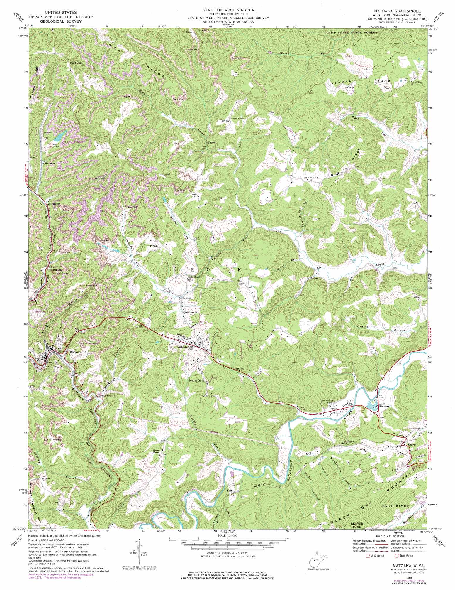
Matoaka Topo Map West Virginia
To zoom in, hover over the map of Matoaka
USGS Topo Quad 37081d2 - 1:24,000 scale
| Topo Map Name: | Matoaka |
| USGS Topo Quad ID: | 37081d2 |
| Print Size: | ca. 21 1/4" wide x 27" high |
| Southeast Coordinates: | 37.375° N latitude / 81.125° W longitude |
| Map Center Coordinates: | 37.4375° N latitude / 81.1875° W longitude |
| U.S. State: | WV |
| Filename: | o37081d2.jpg |
| Download Map JPG Image: | Matoaka topo map 1:24,000 scale |
| Map Type: | Topographic |
| Topo Series: | 7.5´ |
| Map Scale: | 1:24,000 |
| Source of Map Images: | United States Geological Survey (USGS) |
| Alternate Map Versions: |
Matoaka WV 1968, updated 1971 Download PDF Buy paper map Matoaka WV 1968, updated 1977 Download PDF Buy paper map Matoaka WV 2011 Download PDF Buy paper map Matoaka WV 2014 Download PDF Buy paper map Matoaka WV 2016 Download PDF Buy paper map |
1:24,000 Topo Quads surrounding Matoaka
Mcgraws |
Lester |
Crab Orchard |
Shady Spring |
Hinton |
Mullens |
Rhodell |
Odd |
Flat Top |
Pipestem |
Keystone |
Crumpler |
Matoaka |
Athens |
Lerona |
Anawalt |
Bramwell |
Bluefield |
Princeton |
Oakvale |
Tiptop |
Cove Creek |
Bastian |
Rocky Gap |
Mechanicsburg |
> Back to 37081a1 at 1:100,000 scale
> Back to 37080a1 at 1:250,000 scale
> Back to U.S. Topo Maps home
Matoaka topo map: Gazetteer
Matoaka: Bends
Lake Bottom elevation 635m 2083′Matoaka: Dams
Turkey Gap Mine Refuse Dump Dam elevation 843m 2765′Matoaka: Flats
Periwinkle Bottom elevation 633m 2076′Piney Flat elevation 786m 2578′
Matoaka: Lakes
Lake Shawnee elevation 633m 2076′Matoaka: Populated Places
Beeson elevation 716m 2349′Dott elevation 741m 2431′
Hiawatha elevation 732m 2401′
Kale elevation 689m 2260′
Kegley elevation 735m 2411′
Lake Shawnee elevation 633m 2076′
Lashmeet elevation 774m 2539′
Matoaka elevation 719m 2358′
Mount Olive elevation 818m 2683′
Pinoak elevation 835m 2739′
Springton elevation 734m 2408′
Wenonah elevation 746m 2447′
Wimmers Trailer Park elevation 719m 2358′
Matoaka: Post Offices
Beeson Post Office elevation 806m 2644′Dott Post Office elevation 738m 2421′
Hiawatha Post Office elevation 737m 2417′
Lashmeet Post Office elevation 770m 2526′
Matoaka Post Office elevation 719m 2358′
Springton Post Office elevation 737m 2417′
Matoaka: Reservoirs
Turkey Gap Slurry Impoundment elevation 843m 2765′Matoaka: Ridges
Fork Ridge elevation 894m 2933′Morgan Ridge elevation 946m 3103′
Nubbin Ridge elevation 807m 2647′
Stovall Ridge elevation 790m 2591′
Matoaka: Springs
Harvey Spring elevation 747m 2450′Matoaka: Streams
Blankenship Branch elevation 677m 2221′Delashmeet Creek elevation 637m 2089′
Dry Branch elevation 634m 2080′
Ezekiel Branch elevation 658m 2158′
Godfrey Branch elevation 677m 2221′
Mary Branch elevation 718m 2355′
Meadow Fork elevation 703m 2306′
Middleton Fork elevation 639m 2096′
Milton Branch elevation 651m 2135′
Pocosin Fork elevation 652m 2139′
Rocky Branch elevation 631m 2070′
Shrewsbury Branch elevation 636m 2086′
Sugarcamp Branch elevation 647m 2122′
Matoaka: Valleys
Church Hollow elevation 721m 2365′Matoaka digital topo map on disk
Buy this Matoaka topo map showing relief, roads, GPS coordinates and other geographical features, as a high-resolution digital map file on DVD:
Western Virginia & Southern West Virginia
Buy digital topo maps: Western Virginia & Southern West Virginia