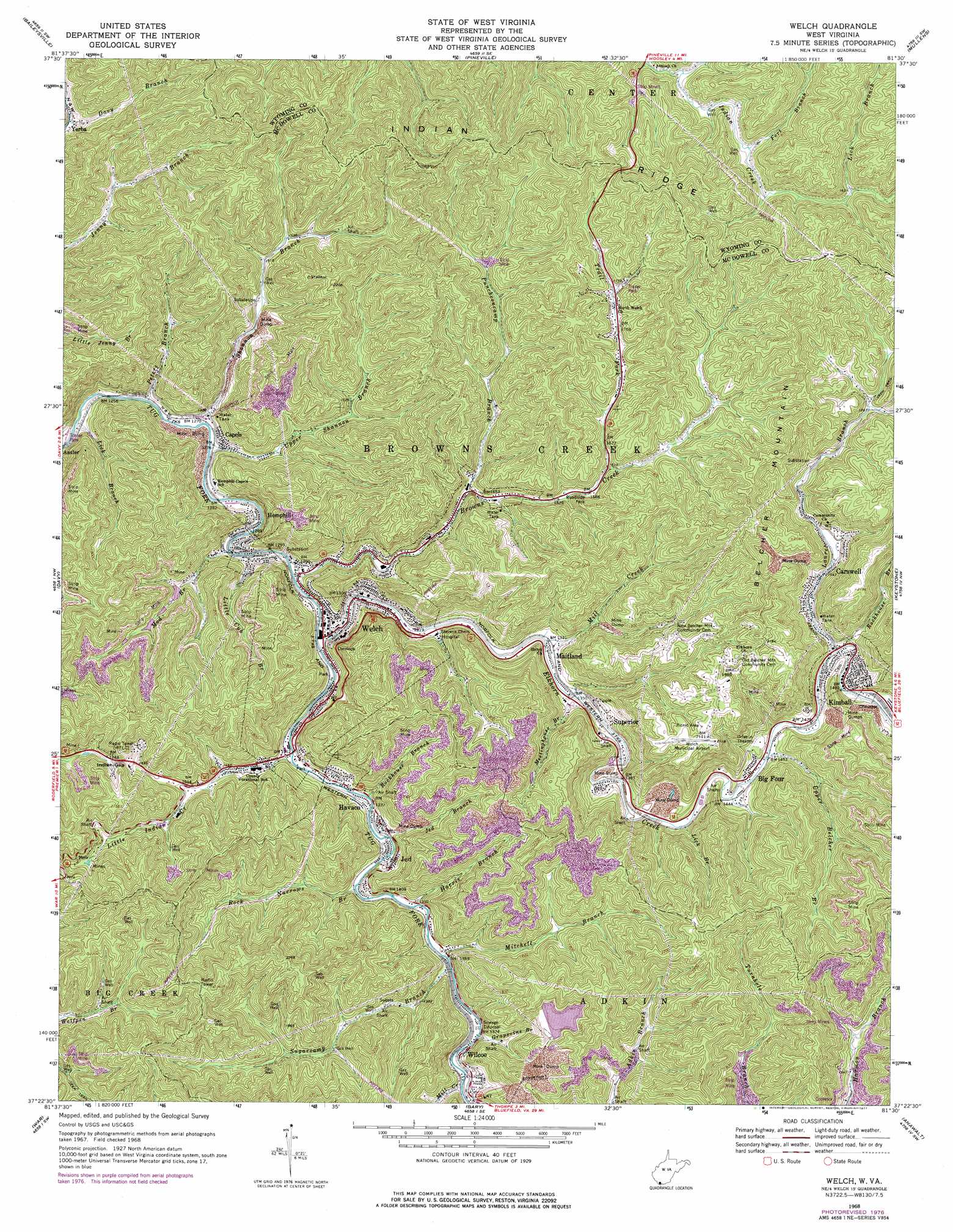
Welch Topo Map West Virginia
To zoom in, hover over the map of Welch
USGS Topo Quad 37081d5 - 1:24,000 scale
| Topo Map Name: | Welch |
| USGS Topo Quad ID: | 37081d5 |
| Print Size: | ca. 21 1/4" wide x 27" high |
| Southeast Coordinates: | 37.375° N latitude / 81.5° W longitude |
| Map Center Coordinates: | 37.4375° N latitude / 81.5625° W longitude |
| U.S. State: | WV |
| Filename: | o37081d5.jpg |
| Download Map JPG Image: | Welch topo map 1:24,000 scale |
| Map Type: | Topographic |
| Topo Series: | 7.5´ |
| Map Scale: | 1:24,000 |
| Source of Map Images: | United States Geological Survey (USGS) |
| Alternate Map Versions: |
Welch WV 1968, updated 1971 Download PDF Buy paper map Welch WV 1968, updated 1977 Download PDF Buy paper map Welch WV 2011 Download PDF Buy paper map Welch WV 2014 Download PDF Buy paper map Welch WV 2016 Download PDF Buy paper map |
1:24,000 Topo Quads surrounding Welch
Mallory |
Oceana |
Matheny |
Mcgraws |
Lester |
Gilbert |
Baileysville |
Pineville |
Mullens |
Rhodell |
Iaeger |
Davy |
Welch |
Keystone |
Crumpler |
Bradshaw |
War |
Gary |
Anawalt |
Bramwell |
Jewell Ridge |
Amonate |
Tazewell North |
Tiptop |
Cove Creek |
> Back to 37081a1 at 1:100,000 scale
> Back to 37080a1 at 1:250,000 scale
> Back to U.S. Topo Maps home
Welch topo map: Gazetteer
Welch: Airports
Welch Municipal Airport elevation 605m 1984′Welch: Dams
Grapevine Branch Refuse and Impoundment Dam elevation 601m 1971′Laurel Branch Dam elevation 580m 1902′
Mod Branch Dam Number Five elevation 524m 1719′
Mod Branch Dam Number Four elevation 486m 1594′
Mod Branch Dam Number One elevation 446m 1463′
Mod Branch Dam Number Three elevation 460m 1509′
Mod Branch Dam Number Two elevation 442m 1450′
Welch: Gaps
Indian Gap elevation 577m 1893′Welch: Populated Places
Antler elevation 396m 1299′Big Four elevation 443m 1453′
Capels elevation 399m 1309′
Carswell elevation 473m 1551′
Havaco elevation 413m 1354′
Hemphill elevation 390m 1279′
Jed elevation 427m 1400′
Kimball elevation 460m 1509′
Maitland elevation 405m 1328′
Superior elevation 431m 1414′
Welch elevation 402m 1318′
Wilcoe elevation 420m 1377′
Yerba elevation 425m 1394′
Welch: Post Offices
Capels Post Office elevation 429m 1407′Superior Post Office elevation 427m 1400′
Welch Post Office elevation 400m 1312′
Welch: Reservoirs
Grapevine Branch Refuse Bank Lake elevation 601m 1971′Welch: Ridges
Indian Ridge elevation 684m 2244′Welch: Springs
Clarence Stewart Spring elevation 550m 1804′Welch: Streams
Big Branch elevation 492m 1614′Browns Creek elevation 391m 1282′
Elkhorn Creek elevation 395m 1295′
Fort Branch elevation 495m 1624′
Grapevine Branch elevation 416m 1364′
Harris Branch elevation 411m 1348′
Jed Branch elevation 406m 1332′
Laurel Branch elevation 449m 1473′
Lick Branch elevation 512m 1679′
Lick Branch elevation 435m 1427′
Lick Branch elevation 379m 1243′
Little Cub Branch elevation 391m 1282′
Little Indian Creek elevation 398m 1305′
Meetinghouse Branch elevation 408m 1338′
Mill Creek elevation 406m 1332′
Mill Creek elevation 420m 1377′
Mitchell Branch elevation 413m 1354′
Mod Branch elevation 391m 1282′
Peters Branch elevation 379m 1243′
Puncheoncamp Branch elevation 453m 1486′
Rock Narrows Branch elevation 404m 1325′
Rockhouse Branch elevation 449m 1473′
Rockhouse Branch elevation 400m 1312′
Shannon Branch elevation 381m 1250′
Sugarcamp Branch elevation 411m 1348′
Trail Fork elevation 495m 1624′
Upper Belcher Branch elevation 440m 1443′
Upper Shannon Branch elevation 385m 1263′
Welch: Summits
Belcher Mountain elevation 683m 2240′Welch digital topo map on disk
Buy this Welch topo map showing relief, roads, GPS coordinates and other geographical features, as a high-resolution digital map file on DVD:
Western Virginia & Southern West Virginia
Buy digital topo maps: Western Virginia & Southern West Virginia