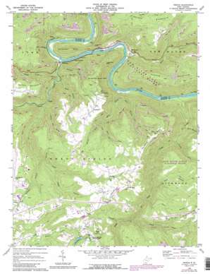
Prince Topo Map West Virginia
To zoom in, hover over the map of Prince
USGS Topo Quad 37081g1 - 1:24,000 scale
| Topo Map Name: | Prince |
| USGS Topo Quad ID: | 37081g1 |
| Print Size: | ca. 21 1/4" wide x 27" high |
| Southeast Coordinates: | 37.75° N latitude / 81° W longitude |
| Map Center Coordinates: | 37.8125° N latitude / 81.0625° W longitude |
| U.S. State: | WV |
| Filename: | o37081g1.jpg |
| Download Map JPG Image: | Prince topo map 1:24,000 scale |
| Map Type: | Topographic |
| Topo Series: | 7.5´ |
| Map Scale: | 1:24,000 |
| Source of Map Images: | United States Geological Survey (USGS) |
| Alternate Map Versions: |
Prince WV 1969, updated 1972 Download PDF Buy paper map Prince WV 1969, updated 1977 Download PDF Buy paper map Prince WV 1969, updated 1989 Download PDF Buy paper map Prince WV 1969, updated 1989 Download PDF Buy paper map Prince WV 2011 Download PDF Buy paper map Prince WV 2014 Download PDF Buy paper map Prince WV 2016 Download PDF Buy paper map |
1:24,000 Topo Quads surrounding Prince
> Back to 37081e1 at 1:100,000 scale
> Back to 37080a1 at 1:250,000 scale
> Back to U.S. Topo Maps home
Prince topo map: Gazetteer
Prince: Airports
Lee Norse Number 2 Heliport elevation 763m 2503′Raleigh County Memorial Airport elevation 757m 2483′
Prince: Crossings
Interchange 129 elevation 851m 2791′Prince: Dams
Little Beaver State Park Lake Dam elevation 782m 2565′Prince: Parks
Grandview State Park (historical) elevation 694m 2276′Prince: Populated Places
Clifftop elevation 768m 2519′Crow elevation 764m 2506′
Export (historical) elevation 530m 1738′
Glade elevation 380m 1246′
Grandview elevation 760m 2493′
Hamlet (historical) elevation 384m 1259′
McCreery elevation 353m 1158′
Norvell (historical) elevation 378m 1240′
Prince elevation 385m 1263′
Quinnimont elevation 386m 1266′
Royal elevation 379m 1243′
Terry elevation 365m 1197′
Terry Junction elevation 364m 1194′
Wright elevation 402m 1318′
Prince: Post Offices
Terry Post Office elevation 570m 1870′Prince: Rapids
Grassy Shoals Rapids elevation 365m 1197′Quinnimont Rapids elevation 357m 1171′
Prince: Reservoirs
Little Beaver Lake elevation 732m 2401′Prince: Ridges
Redden Ridge elevation 855m 2805′Scott Ridge elevation 827m 2713′
Prince: Streams
Batoff Creek elevation 362m 1187′Bills Branch elevation 426m 1397′
Brammer Branch elevation 583m 1912′
Fat Creek elevation 429m 1407′
Glade Creek elevation 368m 1207′
Kates Branch elevation 556m 1824′
Laurel Creek elevation 358m 1174′
Laurel Run elevation 739m 2424′
Little Fat Creek elevation 402m 1318′
Mill Creek elevation 363m 1190′
Packs Branch elevation 372m 1220′
Pedge Branch elevation 623m 2043′
Pinch Creek elevation 593m 1945′
Piney Creek elevation 352m 1154′
Polls Branch elevation 539m 1768′
River Branch elevation 407m 1335′
Scott Branch elevation 618m 2027′
Second Fork elevation 450m 1476′
Slate Fork elevation 529m 1735′
Spruce Fork elevation 529m 1735′
Prince: Summits
Round Knob elevation 884m 2900′Stretcher Neck elevation 591m 1938′
Turkey Spur Rock elevation 700m 2296′
Prince: Tunnels
Stretcher Neck Tunnel elevation 521m 1709′Prince: Valleys
Cyclone Hollow elevation 597m 1958′McCreery Hollow elevation 360m 1181′
Prince digital topo map on disk
Buy this Prince topo map showing relief, roads, GPS coordinates and other geographical features, as a high-resolution digital map file on DVD:
Western Virginia & Southern West Virginia
Buy digital topo maps: Western Virginia & Southern West Virginia


