Arnett Topo Map West Virginia
To zoom in, hover over the map of Arnett
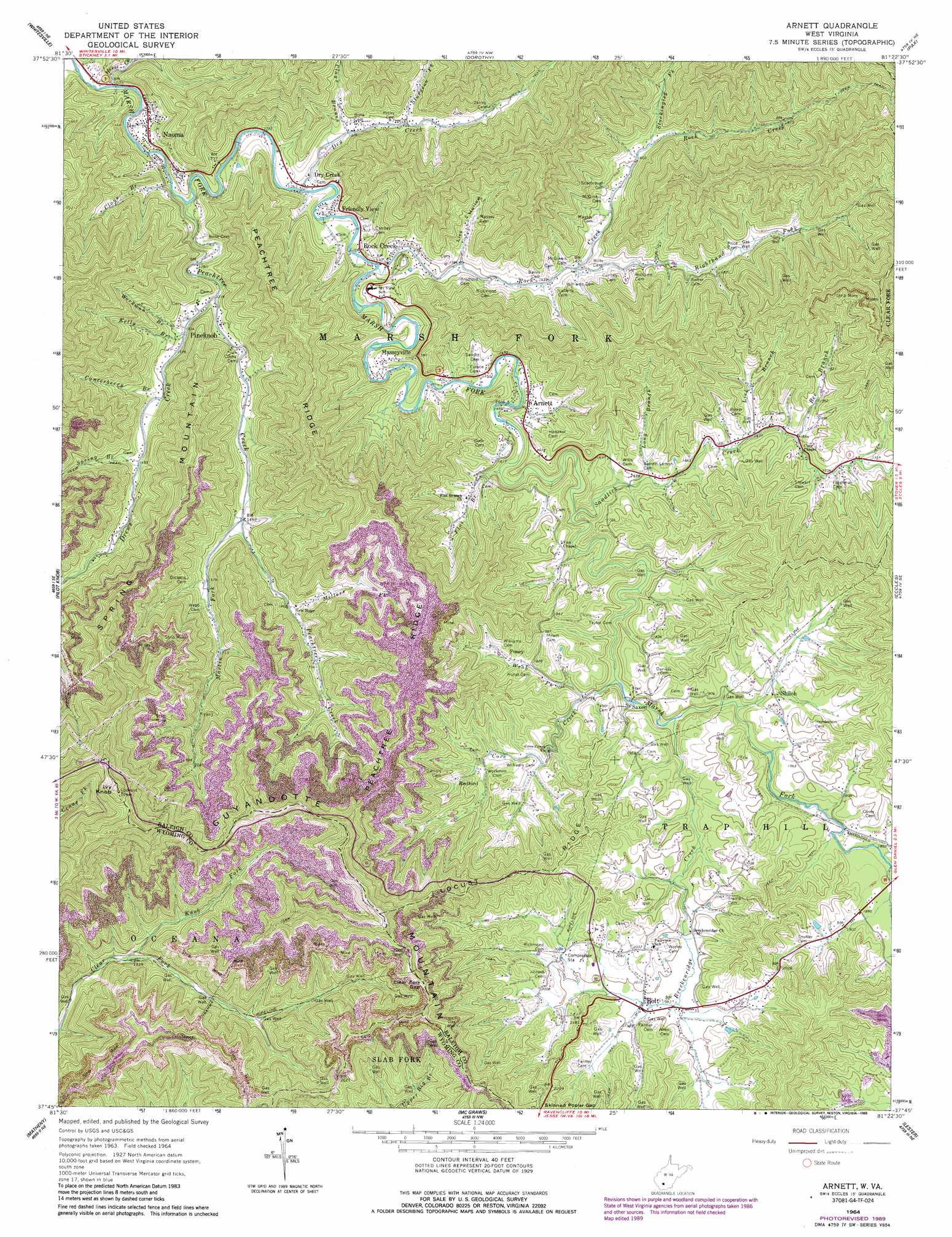
USGS Topo Quad 37081g4 - 1:24,000 scale
| Topo Map Name: | Arnett |
| USGS Topo Quad ID: | 37081g4 |
| Print Size: | ca. 21 1/4" wide x 27" high |
| Southeast Coordinates: | 37.75° N latitude / 81.375° W longitude |
| Map Center Coordinates: | 37.8125° N latitude / 81.4375° W longitude |
| U.S. State: | WV |
| Filename: | o37081g4.jpg |
| Download Map JPG Image: | Arnett topo map 1:24,000 scale |
| Map Type: | Topographic |
| Topo Series: | 7.5´ |
| Map Scale: | 1:24,000 |
| Source of Map Images: | United States Geological Survey (USGS) |
| Alternate Map Versions: |
Arnett WV 1964, updated 1966 Download PDF Buy paper map Arnett WV 1964, updated 1975 Download PDF Buy paper map Arnett WV 1964, updated 1977 Download PDF Buy paper map Arnett WV 1964, updated 1989 Download PDF Buy paper map Arnett WV 2011 Download PDF Buy paper map Arnett WV 2014 Download PDF Buy paper map Arnett WV 2016 Download PDF Buy paper map |
1:24,000 Topo Quads surrounding Arnett
Williams Mountain |
Sylvester |
Eskdale |
Powellton |
Beckwith |
Wharton |
Whitesville |
Dorothy |
Pax |
Oak Hill |
Lorado |
Pilot Knob |
Arnett |
Eccles |
Beckley |
Oceana |
Matheny |
Mcgraws |
Lester |
Crab Orchard |
Baileysville |
Pineville |
Mullens |
Rhodell |
Odd |
> Back to 37081e1 at 1:100,000 scale
> Back to 37080a1 at 1:250,000 scale
> Back to U.S. Topo Maps home
Arnett topo map: Gazetteer
Arnett: Gaps
Clear Fork Gap elevation 869m 2851′Arnett: Populated Places
Arnett elevation 474m 1555′Bolt elevation 606m 1988′
Dry Creek elevation 385m 1263′
Friendly View elevation 409m 1341′
Masseyville elevation 434m 1423′
Naoma elevation 363m 1190′
Pineknob elevation 413m 1354′
Posey elevation 561m 1840′
Redbird elevation 576m 1889′
Rock Creek elevation 404m 1325′
Saxon elevation 534m 1751′
Shiloh elevation 583m 1912′
Zada elevation 518m 1699′
Arnett: Post Offices
Bolt Post Office elevation 606m 1988′Dry Creek Post Office elevation 394m 1292′
Rock Creek Post Office elevation 404m 1325′
Saxon Post Office elevation 532m 1745′
Arnett: Ridges
Locust Ridge elevation 712m 2335′Peachtree Ridge elevation 823m 2700′
Arnett: Streams
Bee Branch elevation 513m 1683′Breckenridge Creek elevation 538m 1765′
Canterberry Branch elevation 436m 1430′
Clays Branch elevation 348m 1141′
Clays Branch elevation 404m 1325′
Cove Creek elevation 527m 1729′
Drews Creek elevation 402m 1318′
Dry Creek elevation 387m 1269′
Flat Branch elevation 466m 1528′
Horse Creek elevation 325m 1066′
Kelly Branch elevation 422m 1384′
Knob Fork elevation 589m 1932′
Lick Branch elevation 511m 1676′
Long Branch elevation 502m 1646′
Maple Meadow Creek elevation 576m 1889′
Martin Fork elevation 453m 1486′
Millers Fork elevation 586m 1922′
Peachtree Creek elevation 353m 1158′
Righthand Fork Rock Creek elevation 444m 1456′
Rock Creek elevation 399m 1309′
Sandlick Creek elevation 484m 1587′
Spanker Branch elevation 572m 1876′
Spring Branch elevation 461m 1512′
Stockingleg Fork elevation 497m 1630′
Sturgeon Fork elevation 427m 1400′
Webb Fork elevation 538m 1765′
Workman Branch elevation 418m 1371′
Arnett: Summits
Ivy Knob elevation 1083m 3553′Spring Mountain elevation 720m 2362′
Arnett: Valleys
Lick Hollow elevation 421m 1381′Arnett digital topo map on disk
Buy this Arnett topo map showing relief, roads, GPS coordinates and other geographical features, as a high-resolution digital map file on DVD:
Western Virginia & Southern West Virginia
Buy digital topo maps: Western Virginia & Southern West Virginia