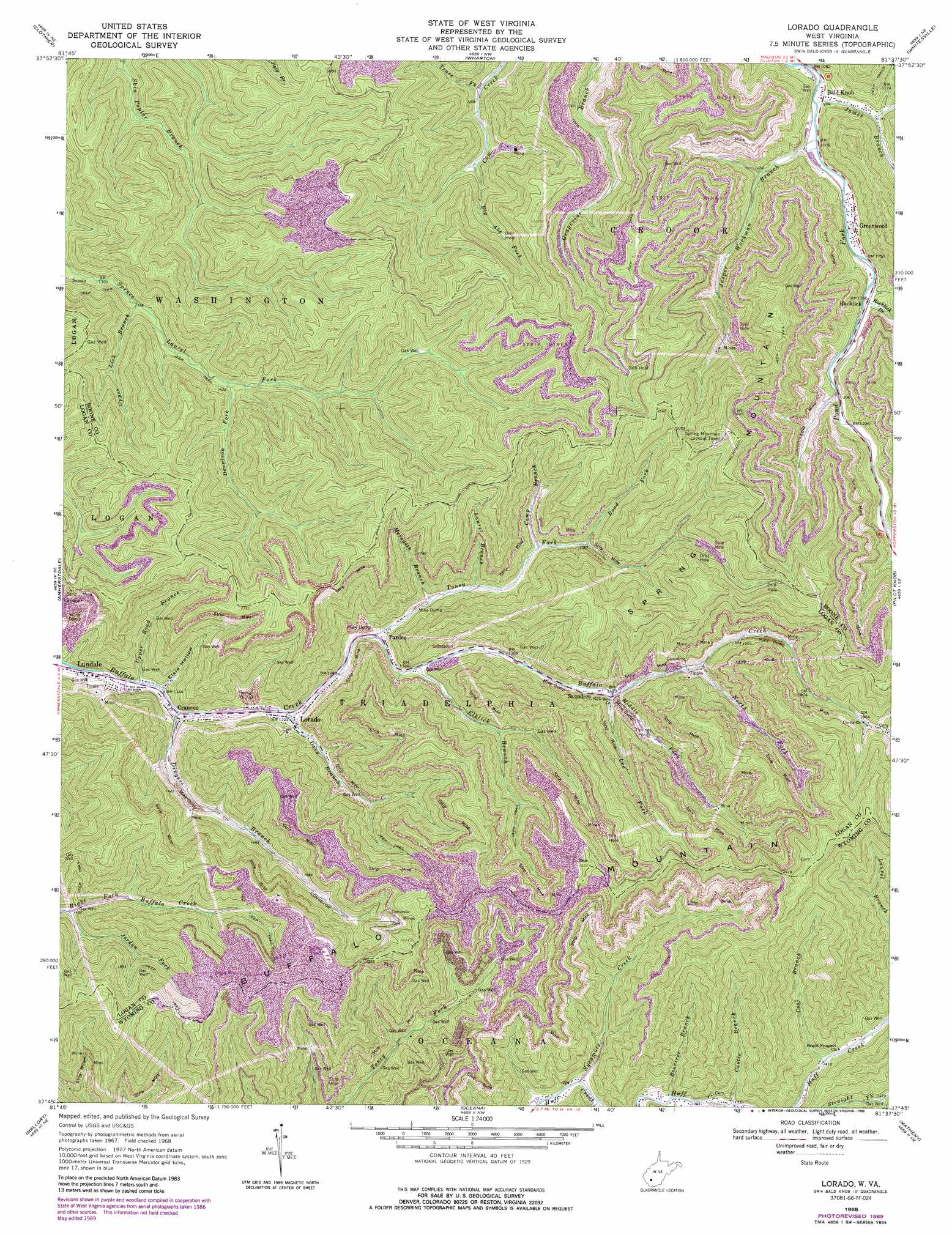
Lorado Topo Map West Virginia
To zoom in, hover over the map of Lorado
USGS Topo Quad 37081g6 - 1:24,000 scale
| Topo Map Name: | Lorado |
| USGS Topo Quad ID: | 37081g6 |
| Print Size: | ca. 21 1/4" wide x 27" high |
| Southeast Coordinates: | 37.75° N latitude / 81.625° W longitude |
| Map Center Coordinates: | 37.8125° N latitude / 81.6875° W longitude |
| U.S. State: | WV |
| Filename: | o37081g6.jpg |
| Download Map JPG Image: | Lorado topo map 1:24,000 scale |
| Map Type: | Topographic |
| Topo Series: | 7.5´ |
| Map Scale: | 1:24,000 |
| Source of Map Images: | United States Geological Survey (USGS) |
| Alternate Map Versions: |
Lorado WV 1968, updated 1971 Download PDF Buy paper map Lorado WV 1968, updated 1977 Download PDF Buy paper map Lorado WV 1968, updated 1989 Download PDF Buy paper map Lorado WV 1996, updated 2003 Download PDF Buy paper map Lorado WV 2011 Download PDF Buy paper map Lorado WV 2014 Download PDF Buy paper map Lorado WV 2016 Download PDF Buy paper map |
1:24,000 Topo Quads surrounding Lorado
Mud |
Madison |
Williams Mountain |
Sylvester |
Eskdale |
Henlawson |
Clothier |
Wharton |
Whitesville |
Dorothy |
Logan |
Amherstdale |
Lorado |
Pilot Knob |
Arnett |
Man |
Mallory |
Oceana |
Matheny |
Mcgraws |
Wharncliffe |
Gilbert |
Baileysville |
Pineville |
Mullens |
> Back to 37081e1 at 1:100,000 scale
> Back to 37080a1 at 1:250,000 scale
> Back to U.S. Topo Maps home
Lorado topo map: Gazetteer
Lorado: Populated Places
Bald Knob elevation 333m 1092′Craneco elevation 356m 1167′
Greenwood elevation 346m 1135′
Lorado elevation 378m 1240′
Lundale elevation 342m 1122′
Pardee elevation 393m 1289′
Rocklick elevation 357m 1171′
Saunders elevation 446m 1463′
Lorado: Post Offices
Bald Knob Post Office elevation 331m 1085′Lorado: Streams
Beartree Branch elevation 396m 1299′Big Abe Fork elevation 410m 1345′
Camp Branch elevation 457m 1499′
Castle Branch elevation 400m 1312′
Coal Branch elevation 427m 1400′
Davy Branch elevation 369m 1210′
Dennison Fork elevation 440m 1443′
Dingess Branch elevation 353m 1158′
Elklick Branch elevation 401m 1315′
James Branch elevation 328m 1076′
Jasper Workman Branch elevation 334m 1095′
Jordan Fork elevation 460m 1509′
Laurel Branch elevation 435m 1427′
Lee Fork elevation 454m 1489′
Meredith Branch elevation 411m 1348′
Middle Fork Buffalo Creek elevation 460m 1509′
North Fork Buffalo Creek elevation 483m 1584′
Road Fork elevation 474m 1555′
Rocklick Branch elevation 353m 1158′
Slickrock Branch elevation 400m 1312′
Sycamore Creek elevation 373m 1223′
Toney Fork elevation 390m 1279′
Trace Fork elevation 374m 1227′
Upper Lick Branch elevation 427m 1400′
Upper Road Branch elevation 347m 1138′
Lorado: Summits
Buffalo Mountain elevation 749m 2457′Spring Mountain elevation 811m 2660′
Lorado: Valleys
Elsie Hollow elevation 353m 1158′Lorado digital topo map on disk
Buy this Lorado topo map showing relief, roads, GPS coordinates and other geographical features, as a high-resolution digital map file on DVD:
Western Virginia & Southern West Virginia
Buy digital topo maps: Western Virginia & Southern West Virginia