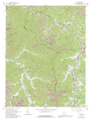
Pax Topo Map West Virginia
To zoom in, hover over the map of Pax
USGS Topo Quad 37081h3 - 1:24,000 scale
| Topo Map Name: | Pax |
| USGS Topo Quad ID: | 37081h3 |
| Print Size: | ca. 21 1/4" wide x 27" high |
| Southeast Coordinates: | 37.875° N latitude / 81.25° W longitude |
| Map Center Coordinates: | 37.9375° N latitude / 81.3125° W longitude |
| U.S. State: | WV |
| Filename: | o37081h3.jpg |
| Download Map JPG Image: | Pax topo map 1:24,000 scale |
| Map Type: | Topographic |
| Topo Series: | 7.5´ |
| Map Scale: | 1:24,000 |
| Source of Map Images: | United States Geological Survey (USGS) |
| Alternate Map Versions: |
Pax WV 1965, updated 1966 Download PDF Buy paper map Pax WV 1965, updated 1977 Download PDF Buy paper map Pax WV 1965, updated 1989 Download PDF Buy paper map Pax WV 1996, updated 2002 Download PDF Buy paper map Pax WV 2011 Download PDF Buy paper map Pax WV 2014 Download PDF Buy paper map Pax WV 2016 Download PDF Buy paper map |
1:24,000 Topo Quads surrounding Pax
> Back to 37081e1 at 1:100,000 scale
> Back to 37080a1 at 1:250,000 scale
> Back to U.S. Topo Maps home
Pax topo map: Gazetteer
Pax: Crossings
Interchange 54 elevation 497m 1630′Interchange 60 elevation 446m 1463′
Pax: Dams
Mcgraw Fork Slurry Dam elevation 554m 1817′Skitter Creek Dam elevation 534m 1751′
Unnamed Tributary of Plum Orchard Creek Dam elevation 461m 1512′
Pax: Populated Places
Artie elevation 411m 1348′Cirtsville elevation 504m 1653′
Clear Creek elevation 447m 1466′
East Kingston elevation 426m 1397′
Kingston elevation 447m 1466′
Lick Fork elevation 454m 1489′
Lively elevation 487m 1597′
Long Branch elevation 526m 1725′
Milburn elevation 347m 1138′
Mossy elevation 432m 1417′
Pax elevation 501m 1643′
Roseville (historical) elevation 501m 1643′
Weirwood elevation 549m 1801′
Westerly elevation 369m 1210′
Willis Branch elevation 499m 1637′
Pax: Post Offices
Artie Post Office elevation 414m 1358′Clear Creek Post Office elevation 444m 1456′
Pax: Reservoirs
Collins Fork Impoundment elevation 653m 2142′Rowland Mine Impoundment elevation 554m 1817′
Pax: Streams
Bee Branch elevation 507m 1663′Bishop Fork elevation 427m 1400′
Boyd Branch elevation 386m 1266′
Boyd Branch elevation 495m 1624′
Buffalo Fork elevation 458m 1502′
Dixons Branch elevation 500m 1640′
Ewing Fork elevation 472m 1548′
Georges Branch elevation 527m 1729′
Goode Creek elevation 446m 1463′
Horse Creek elevation 427m 1400′
Horse Creek elevation 485m 1591′
Knob Branch elevation 496m 1627′
Left Fork White Oak Creek elevation 439m 1440′
Lick Branch elevation 507m 1663′
Lick Fork elevation 457m 1499′
Little Fork elevation 444m 1456′
Long Branch elevation 448m 1469′
Lykins Creek elevation 415m 1361′
Maynor Branch elevation 504m 1653′
McDowell Branch elevation 455m 1492′
McGinnis Branch elevation 447m 1466′
Milburn Creek elevation 395m 1295′
Mossy Creek elevation 429m 1407′
Packs Branch elevation 494m 1620′
Plum Orchard Creek elevation 468m 1535′
Rattlesnake Run elevation 381m 1250′
Reeds Branch elevation 527m 1729′
Right Fork Dixons Branch elevation 524m 1719′
Road Branch elevation 447m 1466′
Skitter Creek elevation 347m 1138′
Stover Fork elevation 487m 1597′
Toney Fork elevation 445m 1459′
Town Creek elevation 487m 1597′
White Oak Creek elevation 405m 1328′
Willis Branch elevation 497m 1630′
Wolfpen Branch elevation 442m 1450′
Workman Creek elevation 465m 1525′
Pax: Summits
High Knob elevation 974m 3195′Hodge Knob elevation 948m 3110′
Lick Knob elevation 989m 3244′
Paint Mountain elevation 904m 2965′
Town Creek Knob elevation 842m 2762′
Pax: Valleys
Austin Hollow elevation 444m 1456′Bear Hollow elevation 421m 1381′
Big Hollow elevation 389m 1276′
Dark Hollow elevation 375m 1230′
Goode Hollow elevation 448m 1469′
Shotgun Hollow elevation 493m 1617′
Veasey Hollow elevation 496m 1627′
Pax digital topo map on disk
Buy this Pax topo map showing relief, roads, GPS coordinates and other geographical features, as a high-resolution digital map file on DVD:
Western Virginia & Southern West Virginia
Buy digital topo maps: Western Virginia & Southern West Virginia


