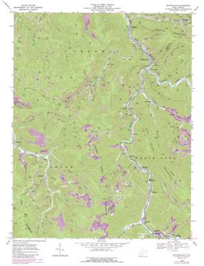
Whitesville Topo Map West Virginia
To zoom in, hover over the map of Whitesville
USGS Topo Quad 37081h5 - 1:24,000 scale
| Topo Map Name: | Whitesville |
| USGS Topo Quad ID: | 37081h5 |
| Print Size: | ca. 21 1/4" wide x 27" high |
| Southeast Coordinates: | 37.875° N latitude / 81.5° W longitude |
| Map Center Coordinates: | 37.9375° N latitude / 81.5625° W longitude |
| U.S. State: | WV |
| Filename: | o37081h5.jpg |
| Download Map JPG Image: | Whitesville topo map 1:24,000 scale |
| Map Type: | Topographic |
| Topo Series: | 7.5´ |
| Map Scale: | 1:24,000 |
| Source of Map Images: | United States Geological Survey (USGS) |
| Alternate Map Versions: |
Whitesville WV 1968, updated 1971 Download PDF Buy paper map Whitesville WV 1968, updated 1977 Download PDF Buy paper map Whitesville WV 1968, updated 1989 Download PDF Buy paper map Whitesville WV 1996, updated 2002 Download PDF Buy paper map Whitesville WV 2011 Download PDF Buy paper map Whitesville WV 2014 Download PDF Buy paper map Whitesville WV 2016 Download PDF Buy paper map |
1:24,000 Topo Quads surrounding Whitesville
> Back to 37081e1 at 1:100,000 scale
> Back to 37080a1 at 1:250,000 scale
> Back to U.S. Topo Maps home
Whitesville topo map: Gazetteer
Whitesville: Parks
Walhonde Roadside Park elevation 278m 912′Whitesville: Populated Places
Birchton elevation 271m 889′Blue Pennant elevation 317m 1040′
Edwight elevation 300m 984′
Elk Run Junction elevation 244m 800′
Eunice elevation 264m 866′
Garrison elevation 321m 1053′
Janie elevation 253m 830′
Jarrolds Valley elevation 253m 830′
Leevale elevation 262m 859′
Lindytown elevation 363m 1190′
Marfork elevation 310m 1017′
Montcoal elevation 286m 938′
Packsville elevation 274m 898′
Pettus elevation 262m 859′
Stickney elevation 291m 954′
Sundial elevation 316m 1036′
Twilight elevation 324m 1062′
Whitesville elevation 256m 839′
Whitesville: Post Offices
Montcoal Post Office elevation 286m 938′Packsville Post Office elevation 279m 915′
Sundial Post Office elevation 324m 1062′
Twilight Post Office elevation 325m 1066′
Whitesville: Reservoirs
Lower Big Branch Refuse Impoundment elevation 274m 898′Robinhood Impoundment elevation 440m 1443′
Whitesville: Streams
Birch Fork elevation 274m 898′Bradley Fork elevation 405m 1328′
Clear Fork elevation 250m 820′
Elk Run elevation 245m 803′
Ellis Creek elevation 284m 931′
Hazy Creek elevation 300m 984′
James Creek elevation 345m 1131′
Little Marsh Fork elevation 258m 846′
Little Ugly Branch elevation 324m 1062′
Low Gap Branch elevation 331m 1085′
Marsh Fork elevation 250m 820′
Matts Creek elevation 374m 1227′
Rockhouse Creek elevation 269m 882′
Seng Creek elevation 239m 784′
Shumate Creek elevation 305m 1000′
Spruce Lick Fork elevation 328m 1076′
Stink Run elevation 308m 1010′
Toms Branch elevation 248m 813′
Whitesville: Summits
Bald Knob elevation 717m 2352′Whitesville: Valleys
Bear Hollow elevation 244m 800′Coon Hollow elevation 312m 1023′
Ducky Ferrell Hollow elevation 361m 1184′
Whitesville digital topo map on disk
Buy this Whitesville topo map showing relief, roads, GPS coordinates and other geographical features, as a high-resolution digital map file on DVD:
Western Virginia & Southern West Virginia
Buy digital topo maps: Western Virginia & Southern West Virginia


