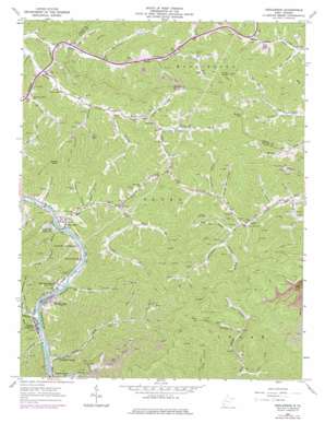
Henlawson Topo Map West Virginia
To zoom in, hover over the map of Henlawson
USGS Topo Quad 37081h8 - 1:24,000 scale
| Topo Map Name: | Henlawson |
| USGS Topo Quad ID: | 37081h8 |
| Print Size: | ca. 21 1/4" wide x 27" high |
| Southeast Coordinates: | 37.875° N latitude / 81.875° W longitude |
| Map Center Coordinates: | 37.9375° N latitude / 81.9375° W longitude |
| U.S. State: | WV |
| Filename: | o37081h8.jpg |
| Download Map JPG Image: | Henlawson topo map 1:24,000 scale |
| Map Type: | Topographic |
| Topo Series: | 7.5´ |
| Map Scale: | 1:24,000 |
| Source of Map Images: | United States Geological Survey (USGS) |
| Alternate Map Versions: |
Henlawson WV 1963, updated 1964 Download PDF Buy paper map Henlawson WV 1963, updated 1974 Download PDF Buy paper map Henlawson WV 1963, updated 1978 Download PDF Buy paper map Henlawson WV 2011 Download PDF Buy paper map Henlawson WV 2014 Download PDF Buy paper map Henlawson WV 2016 Download PDF Buy paper map |
1:24,000 Topo Quads surrounding Henlawson
> Back to 37081e1 at 1:100,000 scale
> Back to 37080a1 at 1:250,000 scale
> Back to U.S. Topo Maps home
Henlawson topo map: Gazetteer
Henlawson: Dams
Peach Creek Dam elevation 409m 1341′Henlawson: Gaps
Barker Gap elevation 446m 1463′Henlawson: Populated Places
Anchor elevation 279m 915′Crooked Creek elevation 210m 688′
Guyan Terrace elevation 205m 672′
Henlawson elevation 203m 666′
Justice Addition elevation 204m 669′
Lake elevation 293m 961′
Manila elevation 238m 780′
Mitchell Heights elevation 204m 669′
North Mitchell Heights elevation 215m 705′
Pecks Mill elevation 211m 692′
Ralumco elevation 201m 659′
Henlawson: Post Offices
Pecks Mill Post Office elevation 205m 672′Henlawson: Reservoirs
Hyer Lake elevation 253m 830′Peach Creek Impoundment elevation 409m 1341′
Ridge View Twin Lakes elevation 231m 757′
Henlawson: Streams
Aleshire Branch elevation 283m 928′Baldwin Fork elevation 303m 994′
Balls Branch elevation 299m 980′
Barker Fork elevation 235m 770′
Big Branch elevation 197m 646′
Bills Branch elevation 198m 649′
Buffalo Creek elevation 193m 633′
Butch Fork elevation 234m 767′
Cloverlick Branch elevation 213m 698′
Craddock Fork elevation 303m 994′
Crooked Creek elevation 195m 639′
Curry Fork elevation 255m 836′
Dent Fork elevation 302m 990′
Dog Fork elevation 243m 797′
Ellis Branch elevation 284m 931′
Gore Fork elevation 245m 803′
Hainer Branch elevation 235m 770′
Hurricane Branch elevation 213m 698′
Isom Branch elevation 277m 908′
Jims Branch elevation 283m 928′
Kanawha Branch elevation 199m 652′
King Shoal Branch elevation 203m 666′
Lake Branch elevation 208m 682′
Long Fork elevation 243m 797′
Meetinghouse Branch elevation 197m 646′
Mill Creek elevation 192m 629′
Neds Branch elevation 209m 685′
Perrys Branch elevation 196m 643′
Pine Fork elevation 282m 925′
Price Branch elevation 190m 623′
Raccoon Branch elevation 324m 1062′
Rocklick Branch elevation 219m 718′
Snap Creek elevation 193m 633′
Stable Branch elevation 216m 708′
Sycamore Branch elevation 310m 1017′
Trace Fork elevation 222m 728′
Wheatley Branch elevation 214m 702′
Henlawson: Summits
Godby Knob elevation 523m 1715′Piney Knob elevation 603m 1978′
Henlawson: Valleys
Big Dark Hollow elevation 329m 1079′Broad Hollow elevation 317m 1040′
Little Dark Hollow elevation 329m 1079′
Henlawson digital topo map on disk
Buy this Henlawson topo map showing relief, roads, GPS coordinates and other geographical features, as a high-resolution digital map file on DVD:
Western Virginia & Southern West Virginia
Buy digital topo maps: Western Virginia & Southern West Virginia


