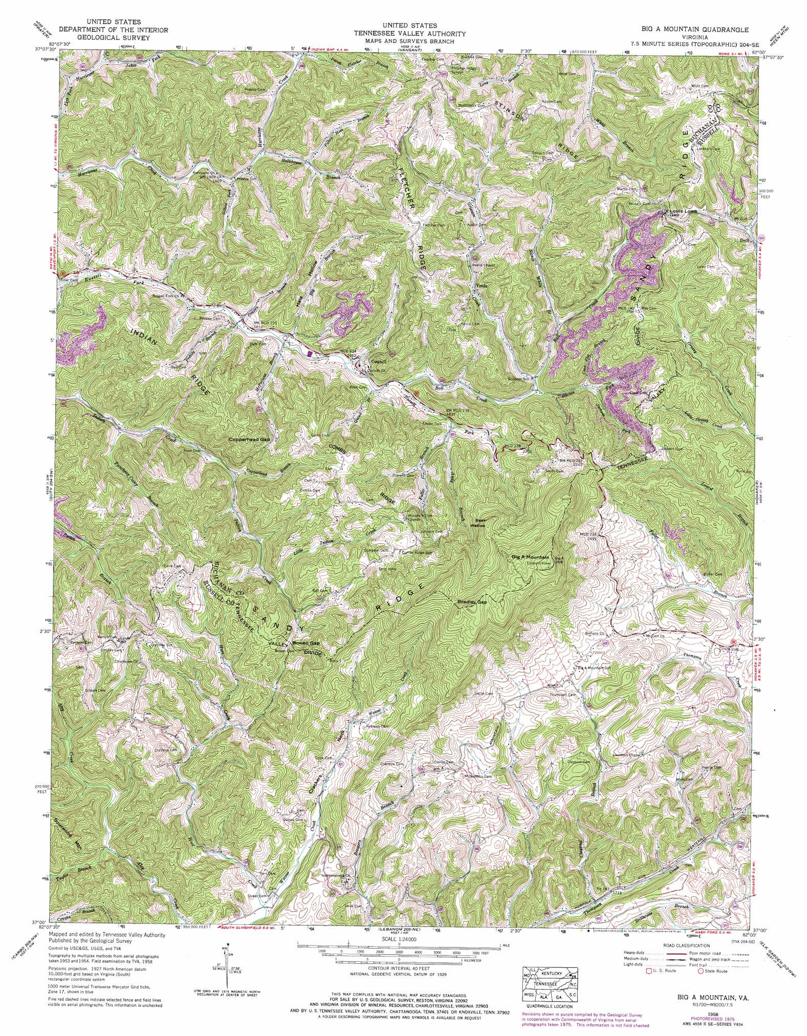
Big A Mountain Topo Map Virginia
To zoom in, hover over the map of Big A Mountain
USGS Topo Quad 37082a1 - 1:24,000 scale
| Topo Map Name: | Big A Mountain |
| USGS Topo Quad ID: | 37082a1 |
| Print Size: | ca. 21 1/4" wide x 27" high |
| Southeast Coordinates: | 37° N latitude / 82° W longitude |
| Map Center Coordinates: | 37.0625° N latitude / 82.0625° W longitude |
| U.S. State: | VA |
| Filename: | o37082a1.jpg |
| Download Map JPG Image: | Big A Mountain topo map 1:24,000 scale |
| Map Type: | Topographic |
| Topo Series: | 7.5´ |
| Map Scale: | 1:24,000 |
| Source of Map Images: | United States Geological Survey (USGS) |
| Alternate Map Versions: |
Big A Mountain VA 1935 Download PDF Buy paper map Big A Mountain VA 1958, updated 1960 Download PDF Buy paper map Big A Mountain VA 1958, updated 1976 Download PDF Buy paper map Big A Mountain VA 1958, updated 1984 Download PDF Buy paper map Big A Mountain VA 2011 Download PDF Buy paper map Big A Mountain VA 2013 Download PDF Buy paper map Big A Mountain VA 2016 Download PDF Buy paper map |
1:24,000 Topo Quads surrounding Big A Mountain
Elkhorn City |
Harman |
Grundy |
Patterson |
Bradshaw |
Haysi |
Prater |
Vansant |
Keen Mountain |
Jewell Ridge |
Nora |
Duty |
Big A Mountain |
Honaker |
Richlands |
Saint Paul |
Carbo |
Lebanon |
Elk Garden |
Saltville |
Moll Creek |
Hansonville |
Brumley |
Hayters Gap |
Glade Spring |
> Back to 37082a1 at 1:100,000 scale
> Back to 37082a1 at 1:250,000 scale
> Back to U.S. Topo Maps home
Big A Mountain topo map: Gazetteer
Big A Mountain: Basins
Bear Wallow elevation 944m 3097′Big A Mountain: Gaps
Bowen Gap elevation 680m 2230′Bradley Gap elevation 1029m 3375′
Copperhead Gap elevation 661m 2168′
Louis Lowe Gap elevation 783m 2568′
Big A Mountain: Populated Places
Council elevation 569m 1866′Flatwoods elevation 606m 1988′
Fuller Corner elevation 688m 2257′
Rasnake elevation 775m 2542′
Venia elevation 600m 1968′
Big A Mountain: Post Offices
Hallie Post Office elevation 716m 2349′Big A Mountain: Ridges
Combs Ridge elevation 795m 2608′Fletcher Ridge elevation 763m 2503′
Indian Ridge elevation 684m 2244′
Stinson Ridge elevation 787m 2582′
Big A Mountain: Streams
Andy Branch elevation 565m 1853′Ball Creek elevation 518m 1699′
Barton Fork elevation 549m 1801′
Big Branch elevation 488m 1601′
Claypool Branch elevation 501m 1643′
Coon Flat Branch elevation 614m 2014′
Copperhead Branch elevation 545m 1788′
Dogpen Branch elevation 477m 1564′
Fuller Branch elevation 504m 1653′
Fuller Branch elevation 574m 1883′
Gilbert Fork elevation 494m 1620′
Grissom Creek elevation 553m 1814′
Hart Creek elevation 506m 1660′
Ivy Lick elevation 476m 1561′
Jackson Fork elevation 598m 1961′
Jakes Fork elevation 491m 1610′
Little Grassy Creek elevation 692m 2270′
Little Indian Creek elevation 606m 1988′
McFarlane Branch elevation 486m 1594′
Nance White Branch elevation 576m 1889′
Parett Fletcher Branch elevation 527m 1729′
Patten Hess Branch elevation 518m 1699′
Pealog Branch elevation 511m 1676′
Presley Branch elevation 477m 1564′
Puncheon Camp Branch elevation 508m 1666′
Quinn Branch elevation 507m 1663′
Rockhouse Branch elevation 534m 1751′
Taylor Branch elevation 560m 1837′
Big A Mountain: Summits
Big A Mountain elevation 1126m 3694′Big A Mountain: Valleys
Crackers Neck elevation 553m 1814′Hale Hollow elevation 497m 1630′
Big A Mountain digital topo map on disk
Buy this Big A Mountain topo map showing relief, roads, GPS coordinates and other geographical features, as a high-resolution digital map file on DVD:
Western Virginia & Southern West Virginia
Buy digital topo maps: Western Virginia & Southern West Virginia