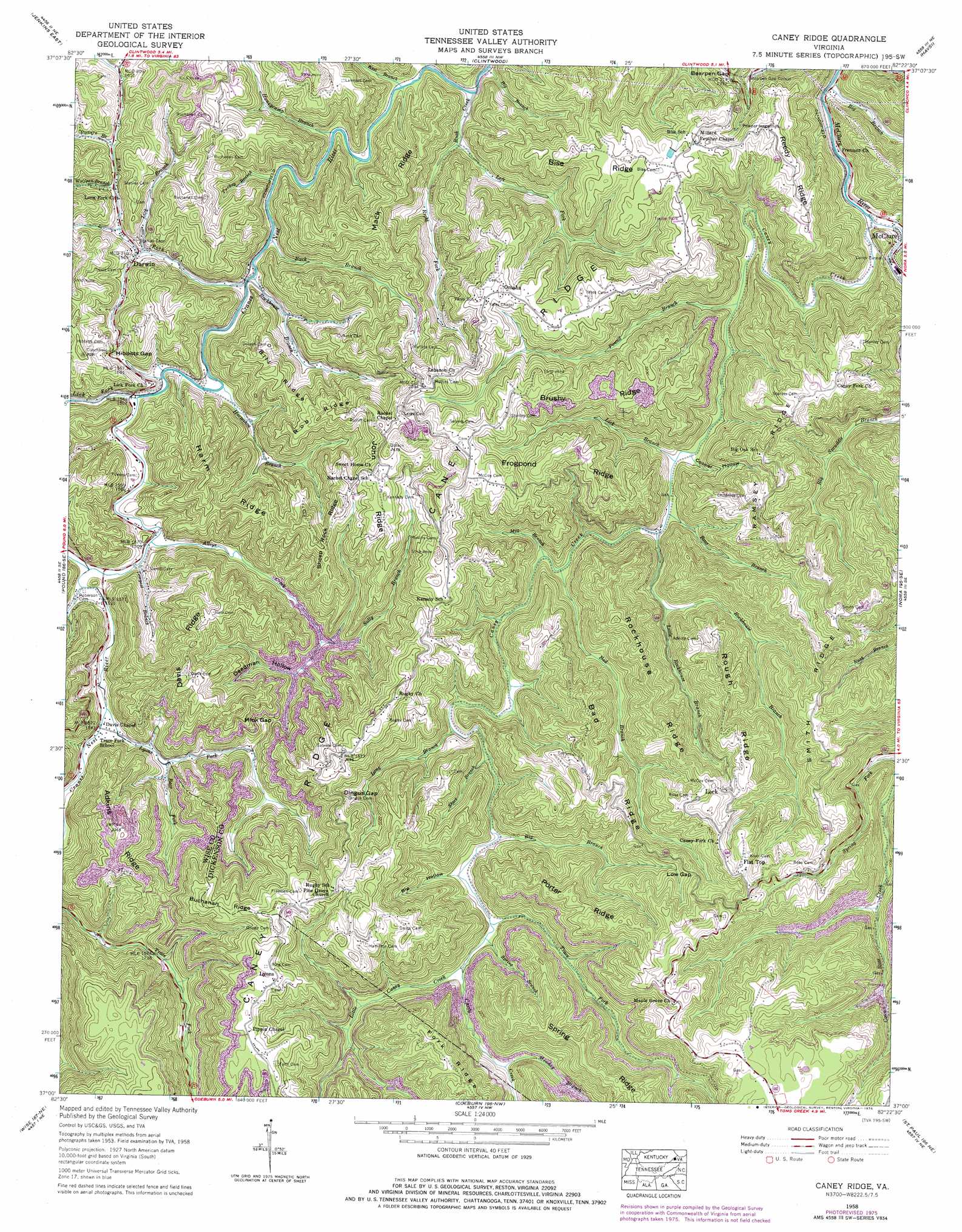
Caney Ridge Topo Map Virginia
To zoom in, hover over the map of Caney Ridge
USGS Topo Quad 37082a4 - 1:24,000 scale
| Topo Map Name: | Caney Ridge |
| USGS Topo Quad ID: | 37082a4 |
| Print Size: | ca. 21 1/4" wide x 27" high |
| Southeast Coordinates: | 37° N latitude / 82.375° W longitude |
| Map Center Coordinates: | 37.0625° N latitude / 82.4375° W longitude |
| U.S. State: | VA |
| Filename: | o37082a4.jpg |
| Download Map JPG Image: | Caney Ridge topo map 1:24,000 scale |
| Map Type: | Topographic |
| Topo Series: | 7.5´ |
| Map Scale: | 1:24,000 |
| Source of Map Images: | United States Geological Survey (USGS) |
| Alternate Map Versions: |
Caney Ridge VA 1958, updated 1960 Download PDF Buy paper map Caney Ridge VA 1958, updated 1976 Download PDF Buy paper map Caney Ridge VA 2011 Download PDF Buy paper map Caney Ridge VA 2013 Download PDF Buy paper map Caney Ridge VA 2016 Download PDF Buy paper map |
1:24,000 Topo Quads surrounding Caney Ridge
Wheelwright |
Dorton |
Hellier |
Elkhorn City |
Harman |
Jenkins West |
Jenkins East |
Clintwood |
Haysi |
Prater |
Flat Gap |
Pound |
Caney Ridge |
Nora |
Duty |
Norton |
Wise |
Coeburn |
Saint Paul |
Carbo |
East Stone Gap |
Fort Blackmore |
Dungannon |
Moll Creek |
Hansonville |
> Back to 37082a1 at 1:100,000 scale
> Back to 37082a1 at 1:250,000 scale
> Back to U.S. Topo Maps home
Caney Ridge topo map: Gazetteer
Caney Ridge: Gaps
Bearpen Gap elevation 591m 1938′Dingus Gap elevation 697m 2286′
Hibbitts Gap elevation 527m 1729′
Low Gap elevation 713m 2339′
Mink Gap elevation 541m 1774′
Caney Ridge: Populated Places
Alka (historical) elevation 548m 1797′Darwin elevation 479m 1571′
Flat Top elevation 776m 2545′
Foraker elevation 454m 1489′
Ibex (historical) elevation 687m 2253′
Leck elevation 733m 2404′
Longfork elevation 490m 1607′
Lyons elevation 822m 2696′
McClure elevation 451m 1479′
Omaha elevation 692m 2270′
Ramsey (historical) elevation 692m 2270′
Smith Corners elevation 735m 2411′
Caney Ridge: Ridges
Adkins Ridge elevation 714m 2342′Bad Ridge elevation 722m 2368′
Bill Ridge elevation 637m 2089′
Bise Ridge elevation 671m 2201′
Brushy Ridge elevation 706m 2316′
Buchanan Ridge elevation 763m 2503′
Caney Ridge elevation 761m 2496′
Davis Ridge elevation 676m 2217′
Frogpond Ridge elevation 717m 2352′
Harm Ridge elevation 630m 2066′
John Ridge elevation 715m 2345′
Mack Ridge elevation 621m 2037′
Porter Ridge elevation 760m 2493′
Ramsey Ridge elevation 708m 2322′
Reedy Ridge elevation 686m 2250′
Rob Ridge elevation 664m 2178′
Rockhouse Ridge elevation 706m 2316′
Rough Ridge elevation 730m 2395′
Sheep Rock Ridge elevation 656m 2152′
Smith Ridge elevation 739m 2424′
Spring Ridge elevation 831m 2726′
Caney Ridge: Streams
Alleys Creek elevation 454m 1489′Bad Branch elevation 492m 1614′
Bear Branch elevation 480m 1574′
Bear Fork elevation 464m 1522′
Big Branch elevation 531m 1742′
Big Branch elevation 444m 1456′
Big Branch elevation 532m 1745′
Big Branch elevation 436m 1430′
Birchfield Creek elevation 453m 1486′
Buck Branch elevation 449m 1473′
Caney Creek elevation 444m 1456′
Crabtree Fork elevation 489m 1604′
Honeycamp Branch elevation 447m 1466′
Horseshoe Branch elevation 458m 1502′
House Branch elevation 556m 1824′
Keel Branch elevation 440m 1443′
Left Fork Rush Creek elevation 444m 1456′
Lick Branch elevation 479m 1571′
Lick Branch elevation 467m 1532′
Lick Fork elevation 456m 1496′
Little Caney Creek elevation 547m 1794′
Little Rockhouse Branch elevation 507m 1663′
Long Branch elevation 515m 1689′
Long Fork elevation 543m 1781′
Low Gap Branch elevation 610m 2001′
Lyons Fork elevation 466m 1528′
Meadow Branch elevation 594m 1948′
Mill Branch elevation 491m 1610′
Pound Branch elevation 468m 1535′
Powers Branch elevation 477m 1564′
Right Fork Rush Creek elevation 444m 1456′
Rockhouse Branch elevation 449m 1473′
Rockhouse Branch elevation 479m 1571′
Rush Creek elevation 442m 1450′
Sally Branch elevation 481m 1578′
Short Branch elevation 534m 1751′
Short Branch elevation 438m 1437′
Spring Branch elevation 541m 1774′
Tempest Branch elevation 454m 1489′
Trace Fork elevation 543m 1781′
Turkey Branch elevation 471m 1545′
Wolfpen Branch elevation 473m 1551′
Caney Ridge: Tunnels
Caney Tunnel elevation 490m 1607′Caney Ridge: Valleys
Big Hollow elevation 540m 1771′Cherrytree Hollow elevation 442m 1450′
Deadman Hollow elevation 495m 1624′
Caney Ridge digital topo map on disk
Buy this Caney Ridge topo map showing relief, roads, GPS coordinates and other geographical features, as a high-resolution digital map file on DVD:
Western Virginia & Southern West Virginia
Buy digital topo maps: Western Virginia & Southern West Virginia