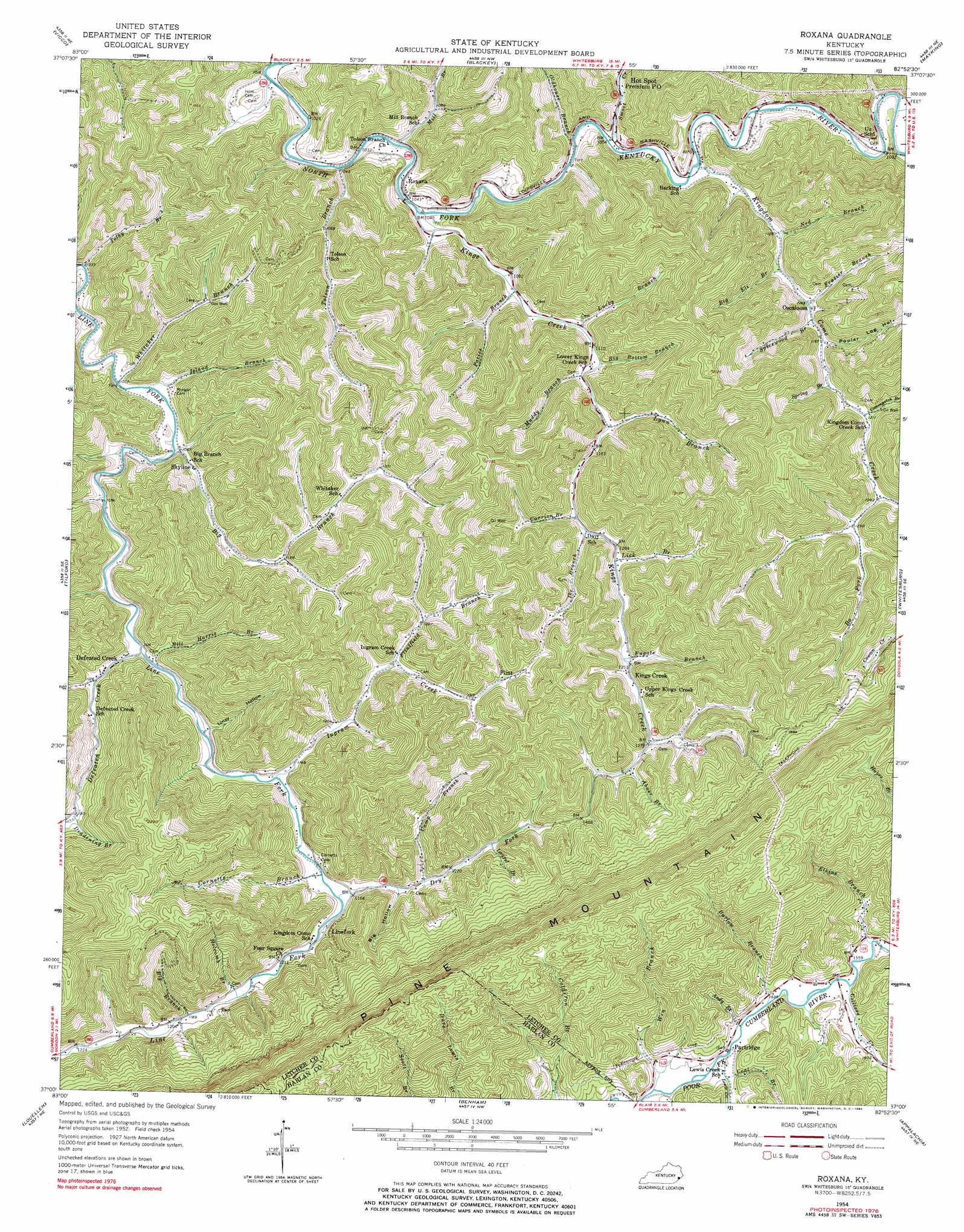
Roxana Topo Map Kentucky
To zoom in, hover over the map of Roxana
USGS Topo Quad 37082a8 - 1:24,000 scale
| Topo Map Name: | Roxana |
| USGS Topo Quad ID: | 37082a8 |
| Print Size: | ca. 21 1/4" wide x 27" high |
| Southeast Coordinates: | 37° N latitude / 82.875° W longitude |
| Map Center Coordinates: | 37.0625° N latitude / 82.9375° W longitude |
| U.S. State: | KY |
| Filename: | o37082a8.jpg |
| Download Map JPG Image: | Roxana topo map 1:24,000 scale |
| Map Type: | Topographic |
| Topo Series: | 7.5´ |
| Map Scale: | 1:24,000 |
| Source of Map Images: | United States Geological Survey (USGS) |
| Alternate Map Versions: |
Roxana KY 1954, updated 1956 Download PDF Buy paper map Roxana KY 1954, updated 1967 Download PDF Buy paper map Roxana KY 1954, updated 1984 Download PDF Buy paper map Roxana KY 2010 Download PDF Buy paper map Roxana KY 2013 Download PDF Buy paper map Roxana KY 2016 Download PDF Buy paper map |
| FStopo: | US Forest Service topo Roxana is available: Download FStopo PDF Download FStopo TIF |
1:24,000 Topo Quads surrounding Roxana
Hazard North |
Carrie |
Hindman |
Kite |
Wheelwright |
Hazard South |
Vicco |
Blackey |
Mayking |
Jenkins West |
Leatherwood |
Tilford |
Roxana |
Whitesburg |
Flat Gap |
Nolansburg |
Louellen |
Benham |
Appalachia |
Norton |
Evarts |
Pennington Gap |
Keokee |
Big Stone Gap |
East Stone Gap |
> Back to 37082a1 at 1:100,000 scale
> Back to 37082a1 at 1:250,000 scale
> Back to U.S. Topo Maps home
Roxana topo map: Gazetteer
Roxana: Parks
Lilley Cornett Woods elevation 441m 1446′Roxana: Populated Places
Defeated Creek elevation 336m 1102′Flint elevation 415m 1361′
Hubert (historical) elevation 335m 1099′
Kingdom Come elevation 372m 1220′
Kings Creek elevation 389m 1276′
Line Fork elevation 357m 1171′
Linefork elevation 378m 1240′
Oscaloosa elevation 354m 1161′
Partridge elevation 468m 1535′
Roxana elevation 326m 1069′
Skyline elevation 328m 1076′
Roxana: Post Offices
Alice Post Office (historical) elevation 327m 1072′Cape Post Office (historical) elevation 365m 1197′
Chestnut Hill Post Office (historical) elevation 322m 1056′
Connetts Post Office (historical) elevation 351m 1151′
Defeated Creek Post Office (historical) elevation 338m 1108′
Extra Post Office (historical) elevation 313m 1026′
Field Post Office (historical) elevation 330m 1082′
Flint Post Office (historical) elevation 414m 1358′
Hot Spot Premium Post Office elevation 338m 1108′
King Creek Post Office (historical) elevation 405m 1328′
Lewis Creek Post Office (historical) elevation 462m 1515′
Line Fork Post Office elevation 451m 1479′
Maggard Post Office (historical) elevation 474m 1555′
Partride Post Office elevation 471m 1545′
Skyline Post Office (historical) elevation 334m 1095′
UZ Post Office (historical) elevation 342m 1122′
Roxana: Streams
Abner Branch elevation 400m 1312′Andy Branch elevation 468m 1535′
Barlow Branch elevation 470m 1541′
Big Bottom Branch elevation 353m 1158′
Big Branch elevation 364m 1194′
Big Branch elevation 326m 1069′
Big Eli Branch elevation 364m 1194′
Bill Harris Branch elevation 339m 1112′
Bo Fork elevation 387m 1269′
Camp Branch elevation 372m 1220′
Carrion Branch elevation 362m 1187′
Coal Branch elevation 470m 1541′
Colliers Creek elevation 467m 1532′
Cornetts Branch elevation 348m 1141′
Cottonpatch Branch elevation 374m 1227′
Day-Long Branch elevation 394m 1292′
Deadening Branch elevation 388m 1272′
Defeated Creek elevation 334m 1095′
Dry Fork elevation 328m 1076′
Dry Fork elevation 347m 1138′
Elkins Branch elevation 473m 1551′
Flintfield Branch elevation 383m 1256′
Frazier Branch elevation 352m 1154′
Fugate Branch elevation 373m 1223′
Holcomb Branch elevation 358m 1174′
Ike Branch elevation 377m 1236′
Ingram Creek elevation 351m 1151′
Island Branch elevation 329m 1079′
Kingdom Come Creek elevation 322m 1056′
Kings Creek elevation 317m 1040′
Laurel Branch elevation 398m 1305′
Lewis Creek elevation 462m 1515′
Lick Branch elevation 370m 1213′
Looney Branch elevation 347m 1138′
Lucky Branch elevation 340m 1115′
Lynn Branch elevation 352m 1154′
Mill Branch elevation 315m 1033′
Muddy Branch elevation 358m 1174′
Ned Branch elevation 340m 1115′
Oldhouse Branch elevation 319m 1046′
Pacies Branch elevation 336m 1102′
Smoot Creek elevation 325m 1066′
Sparkman Branch elevation 328m 1076′
Spicewood Branch elevation 363m 1190′
Spring Branch elevation 360m 1181′
Staggerweed Branch elevation 387m 1269′
Tolby Branch elevation 318m 1043′
Tolson Branch elevation 315m 1033′
Whitaker Branch elevation 321m 1053′
Win Branch elevation 462m 1515′
Roxana: Valleys
Big Hollow elevation 365m 1197′Linzy Hollow elevation 347m 1138′
Poplar Log Hollow elevation 364m 1194′
Roxana digital topo map on disk
Buy this Roxana topo map showing relief, roads, GPS coordinates and other geographical features, as a high-resolution digital map file on DVD:
Western Virginia & Southern West Virginia
Buy digital topo maps: Western Virginia & Southern West Virginia