Harman Topo Map Virginia
To zoom in, hover over the map of Harman
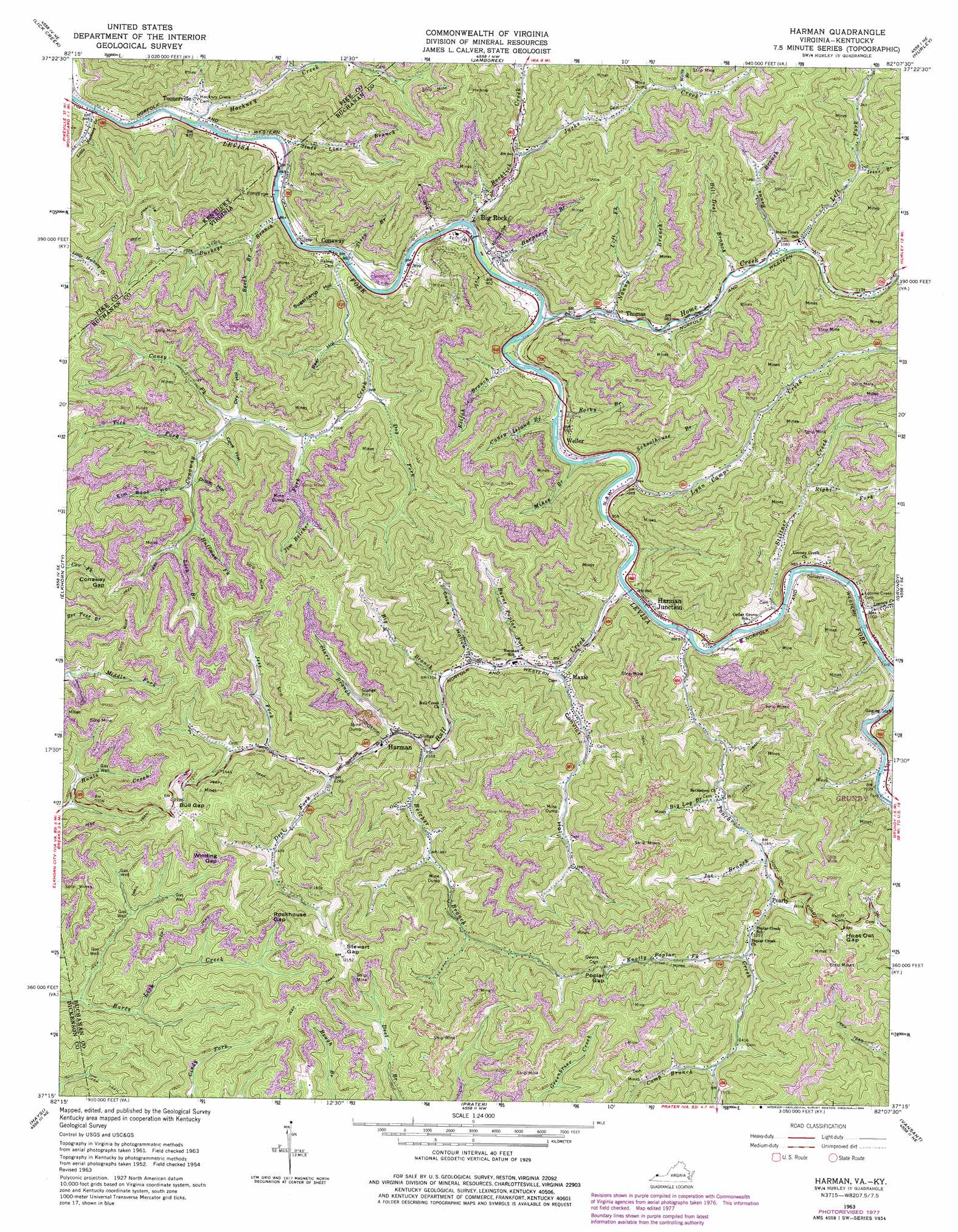
USGS Topo Quad 37082c2 - 1:24,000 scale
| Topo Map Name: | Harman |
| USGS Topo Quad ID: | 37082c2 |
| Print Size: | ca. 21 1/4" wide x 27" high |
| Southeast Coordinates: | 37.25° N latitude / 82.125° W longitude |
| Map Center Coordinates: | 37.3125° N latitude / 82.1875° W longitude |
| U.S. States: | VA, KY |
| Filename: | o37082c2.jpg |
| Download Map JPG Image: | Harman topo map 1:24,000 scale |
| Map Type: | Topographic |
| Topo Series: | 7.5´ |
| Map Scale: | 1:24,000 |
| Source of Map Images: | United States Geological Survey (USGS) |
| Alternate Map Versions: |
Harman VA 1954, updated 1955 Download PDF Buy paper map Harman VA 1963, updated 1965 Download PDF Buy paper map Harman VA 1963, updated 1976 Download PDF Buy paper map Harman VA 1963, updated 1978 Download PDF Buy paper map Harman VA 1963, updated 1984 Download PDF Buy paper map Harman VA 2011 Download PDF Buy paper map Harman VA 2013 Download PDF Buy paper map Harman VA 2016 Download PDF Buy paper map |
1:24,000 Topo Quads surrounding Harman
Meta |
Belfry |
Matewan |
Majestic |
Wharncliffe |
Millard |
Lick Creek |
Jamboree |
Hurley |
Panther |
Hellier |
Elkhorn City |
Harman |
Grundy |
Patterson |
Clintwood |
Haysi |
Prater |
Vansant |
Keen Mountain |
Caney Ridge |
Nora |
Duty |
Big A Mountain |
Honaker |
> Back to 37082a1 at 1:100,000 scale
> Back to 37082a1 at 1:250,000 scale
> Back to U.S. Topo Maps home
Harman topo map: Gazetteer
Harman: Airports
United Coal Heliport elevation 310m 1017′Wellmore Heliport elevation 471m 1545′
Harman: Dams
Harman Mining Corporation Dam elevation 452m 1482′Star Branch Dam Number One elevation 420m 1377′
Harman: Gaps
Bull Gap elevation 654m 2145′Conaway Gap elevation 529m 1735′
Hoot Owl Gap elevation 575m 1886′
Poplar Gap elevation 560m 1837′
Rockhouse Gap elevation 597m 1958′
Stewart Gap elevation 655m 2148′
Winding Gap elevation 573m 1879′
Harman: Populated Places
Artia elevation 290m 951′Big Rock elevation 280m 918′
Conaway elevation 262m 859′
Hackney Creek elevation 284m 931′
Harman elevation 372m 1220′
Harman Junction elevation 293m 961′
Maxie elevation 325m 1066′
Pearly elevation 399m 1309′
Thomas elevation 286m 938′
Toonerville elevation 282m 925′
Weller elevation 279m 915′
Harman: Reservoirs
Harman Mining Corporation Pond elevation 452m 1482′Harman: Streams
Beech Branch elevation 289m 948′Belcher Branch elevation 357m 1171′
Benns Branch elevation 322m 1056′
Big Branch elevation 340m 1115′
Big Log Branch elevation 356m 1167′
Bill Deel Branch elevation 316m 1036′
Buckeye Branch elevation 271m 889′
Bull Creek elevation 287m 941′
Burnt Poplar Fork elevation 316m 1036′
Camp Branch elevation 449m 1473′
Canaway Creek elevation 268m 879′
Caney Fork elevation 328m 1076′
Caney Island Branch elevation 289m 948′
Conaway Creek elevation 263m 862′
Deel Fork elevation 399m 1309′
Dog Fork elevation 298m 977′
Elijah Branch elevation 279m 915′
Hackney Creek elevation 259m 849′
Harper Branch elevation 274m 898′
Home Creek elevation 273m 895′
Huffman Fork elevation 372m 1220′
Issac Branch elevation 374m 1227′
Jacks Creek elevation 314m 1030′
Jess Fork elevation 399m 1309′
Jim Belcher Fork elevation 313m 1026′
Joe Branch elevation 377m 1236′
Knotty Poplar Fork elevation 401m 1315′
Left Branch Nanny Branch elevation 329m 1079′
Left Fork Bull Creek elevation 309m 1013′
Left Fork Home Creek elevation 325m 1066′
Lick Branch elevation 391m 1282′
Little Hackney Creek elevation 305m 1000′
Looney Creek elevation 295m 967′
Lynn Camp Creek elevation 283m 928′
Mikes Branch elevation 280m 918′
Nanny Branch elevation 289m 948′
Poplar Creek elevation 295m 967′
Right Fork Stiltner Creek elevation 388m 1272′
Rocklick Creek elevation 268m 879′
Rocky Branch elevation 278m 912′
Schoolhouse Branch elevation 282m 925′
Six and Twentymile Creek elevation 304m 997′
Starr Branch elevation 365m 1197′
State Line Branch elevation 258m 846′
Steep Branch elevation 263m 862′
Stiltner Creek elevation 295m 967′
Tick Fork elevation 341m 1118′
Watts Branch elevation 369m 1210′
Harman: Valleys
Bear Hollow elevation 291m 954′Convict Hollow elevation 311m 1020′
Cove Hollow elevation 326m 1069′
Cove Hollow elevation 332m 1089′
Ditch Hollow elevation 350m 1148′
Dry Hollow elevation 329m 1079′
Elm Root Hollow elevation 354m 1161′
Pigeonroost Hollow elevation 304m 997′
Sugarcamp Hollow elevation 281m 921′
Harman digital topo map on disk
Buy this Harman topo map showing relief, roads, GPS coordinates and other geographical features, as a high-resolution digital map file on DVD:
Western Virginia & Southern West Virginia
Buy digital topo maps: Western Virginia & Southern West Virginia