Elkhorn City Topo Map Kentucky
To zoom in, hover over the map of Elkhorn City
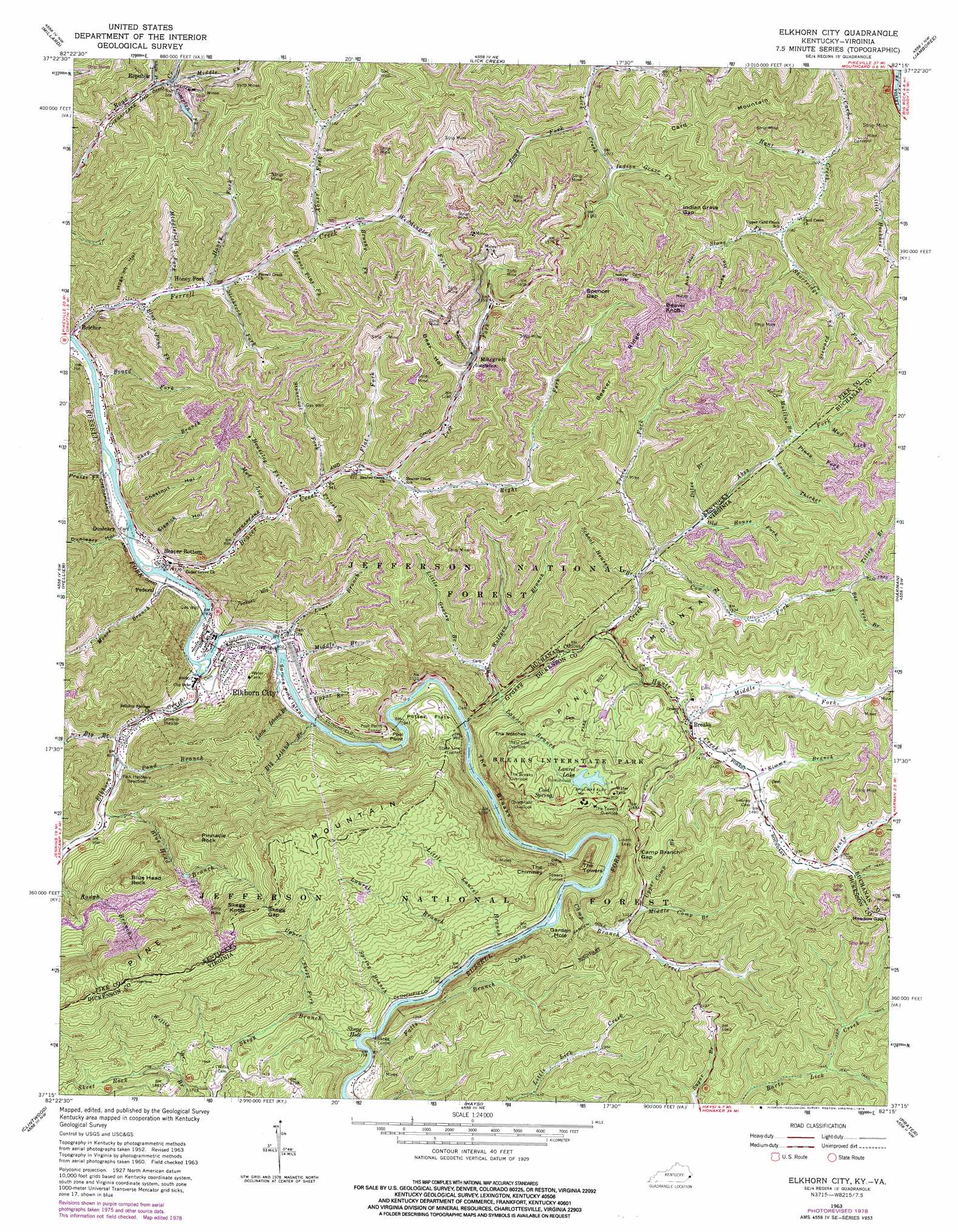
USGS Topo Quad 37082c3 - 1:24,000 scale
| Topo Map Name: | Elkhorn City |
| USGS Topo Quad ID: | 37082c3 |
| Print Size: | ca. 21 1/4" wide x 27" high |
| Southeast Coordinates: | 37.25° N latitude / 82.25° W longitude |
| Map Center Coordinates: | 37.3125° N latitude / 82.3125° W longitude |
| U.S. States: | KY, VA |
| Filename: | o37082c3.jpg |
| Download Map JPG Image: | Elkhorn City topo map 1:24,000 scale |
| Map Type: | Topographic |
| Topo Series: | 7.5´ |
| Map Scale: | 1:24,000 |
| Source of Map Images: | United States Geological Survey (USGS) |
| Alternate Map Versions: |
Elkhorn City KY 1954, updated 1955 Download PDF Buy paper map Elkhorn City KY 1963, updated 1964 Download PDF Buy paper map Elkhorn City KY 1963, updated 1974 Download PDF Buy paper map Elkhorn City KY 1963, updated 1978 Download PDF Buy paper map Elkhorn City KY 2011 Download PDF Buy paper map Elkhorn City KY 2013 Download PDF Buy paper map Elkhorn City KY 2016 Download PDF Buy paper map |
| FStopo: | US Forest Service topo Elkhorn City is available: Download FStopo PDF Download FStopo TIF |
1:24,000 Topo Quads surrounding Elkhorn City
Broad Bottom |
Meta |
Belfry |
Matewan |
Majestic |
Pikeville |
Millard |
Lick Creek |
Jamboree |
Hurley |
Dorton |
Hellier |
Elkhorn City |
Harman |
Grundy |
Jenkins East |
Clintwood |
Haysi |
Prater |
Vansant |
Pound |
Caney Ridge |
Nora |
Duty |
Big A Mountain |
> Back to 37082a1 at 1:100,000 scale
> Back to 37082a1 at 1:250,000 scale
> Back to U.S. Topo Maps home
Elkhorn City topo map: Gazetteer
Elkhorn City: Bays
Garden Hole elevation 332m 1089′Skegg Hole elevation 348m 1141′
Elkhorn City: Bridges
Pool Point Bridge elevation 248m 813′Elkhorn City: Capes
Pool Point elevation 248m 813′Elkhorn City: Cliffs
Lovers Leap elevation 459m 1505′The Breaks elevation 332m 1089′
Elkhorn City: Dams
Laurel Lake Dam elevation 536m 1758′Elkhorn City: Flats
Potter Flats elevation 292m 958′Elkhorn City: Gaps
Camp Branch Gap elevation 486m 1594′Indian Grave Gap elevation 497m 1630′
Meadow Gap elevation 582m 1909′
Skegg Gap elevation 828m 2716′
Skegg Gap elevation 746m 2447′
Spencer Gap elevation 594m 1948′
The Notches elevation 519m 1702′
Elkhorn City: Islands
Spruce Pine Island elevation 244m 800′Elkhorn City: Parks
Breaks Interstate Park elevation 548m 1797′Elkhorn City: Populated Places
Beaver Bottom elevation 237m 777′Beaver Creek elevation 279m 915′
Belcher elevation 238m 780′
Breaks elevation 451m 1479′
Cedarville elevation 303m 994′
Dunleary elevation 233m 764′
Elkhorn City elevation 241m 790′
Federal elevation 241m 790′
Ferrell elevation 262m 859′
Honey Fork elevation 267m 875′
Mikegrady elevation 439m 1440′
Republic elevation 326m 1069′
Senterville elevation 244m 800′
Elkhorn City: Post Offices
Belcher Post Office (historical) elevation 231m 757′Dunleary Post Office (historical) elevation 241m 790′
Elkhorn City Post Office elevation 240m 787′
Ferrell Post Office (historical) elevation 248m 813′
Elkhorn City: Reservoirs
Laurel Lake elevation 536m 1758′Elkhorn City: Ridges
Beaver Ridge elevation 603m 1978′Elkhorn City: Springs
Cold Spring elevation 561m 1840′Elkhorn City: Streams
Abes Fork elevation 340m 1115′Abes Fork elevation 355m 1164′
Abner Fork elevation 310m 1017′
Beaver Creek elevation 230m 754′
Bee Tree Branch elevation 425m 1394′
Big Branch elevation 251m 823′
Big Island Branch elevation 238m 780′
Blue Head Branch elevation 256m 839′
Blue Pond Fork elevation 243m 797′
Board Fork elevation 226m 741′
Brushy Fork elevation 334m 1095′
Camp Branch Creek elevation 326m 1069′
Compton Fork elevation 352m 1154′
Cow Fork elevation 339m 1112′
Cow Fork elevation 355m 1164′
Dilse Branch elevation 351m 1151′
Dilse Branch elevation 352m 1154′
Falls Branch elevation 361m 1184′
Flat Fork elevation 294m 964′
Grassy Creek elevation 249m 816′
Grassy Creek elevation 255m 836′
Honey Fork elevation 312m 1023′
Houselog Fork elevation 278m 912′
Hunt Fork elevation 317m 1040′
Hunts Creek elevation 323m 1059′
Indian Grave Fork elevation 365m 1197′
Isham Fork elevation 325m 1066′
John Moore Branch elevation 231m 757′
Laurel Branch elevation 280m 918′
Laurel Branch elevation 340m 1115′
Left Fork Beaver Creek elevation 304m 997′
Little Grassy Branch elevation 291m 954′
Little Island Branch elevation 251m 823′
Little Laurel Branch elevation 344m 1128′
Locust Thicket elevation 371m 1217′
Locust Thicket elevation 379m 1243′
Lower Branch elevation 245m 803′
Maple Camp Fork elevation 374m 1227′
Middle Branch elevation 247m 810′
Middle Camp Branch elevation 394m 1292′
Middle Fork Hunts Creek elevation 443m 1453′
Middle Fork Road Creek elevation 352m 1154′
Middlefield Fork elevation 252m 826′
Mud Lick elevation 289m 948′
Mud Lick elevation 399m 1309′
Mullins Branch elevation 384m 1259′
Old House Fork elevation 377m 1236′
Old House Fork elevation 349m 1145′
Piney Fork elevation 390m 1279′
Piney Fork elevation 379m 1243′
Pond Branch elevation 251m 823′
Potter Branch elevation 399m 1309′
Praise Fork elevation 225m 738′
Priest Fork elevation 285m 935′
Right Fork Beaver Creek elevation 304m 997′
Road Fork elevation 312m 1023′
School House Branch elevation 336m 1102′
Shop Branch elevation 233m 764′
Shortridge Fork elevation 335m 1099′
Simms Branch elevation 447m 1466′
Skegg Branch elevation 351m 1151′
Slickrock Fork elevation 265m 869′
Slone Fork elevation 335m 1099′
Spring Branch elevation 351m 1151′
Spruce Pine Fork elevation 298m 977′
Steward Fork elevation 385m 1263′
Stonecoal Fork elevation 286m 938′
Tilley Branch elevation 425m 1394′
Trace Fork elevation 344m 1128′
Trace Fork elevation 339m 1112′
Upper Branch elevation 244m 800′
Upper Camp Branch elevation 407m 1335′
Upper Skegg Fork elevation 435m 1427′
Weddington Fork elevation 363m 1190′
Willis Branch elevation 528m 1732′
Wolfpen Branch elevation 311m 1020′
Elkhorn City: Summits
Beaver Knob elevation 638m 2093′Blue Head Knob elevation 558m 1830′
Blue Head Rock elevation 636m 2086′
Card Mountain elevation 545m 1788′
Greasy Spear elevation 399m 1309′
Pinnacle Rock elevation 619m 2030′
Skegg Knob elevation 786m 2578′
Skegg Knob elevation 827m 2713′
The Chimney elevation 501m 1643′
The Towers elevation 498m 1633′
Elkhorn City: Tunnels
Pool Point Tunnel elevation 322m 1056′Skegg Tunnel elevation 401m 1315′
State Line Tunnel elevation 342m 1122′
Towers Tunnel elevation 414m 1358′
Elkhorn City: Valleys
Axel Hollow elevation 397m 1302′Bear Hollow elevation 378m 1240′
Chestnut Hollow elevation 236m 774′
Cold Bank Hollow elevation 326m 1069′
Dunleary Hollow elevation 238m 780′
Elswick Hollow elevation 259m 849′
Hogston Hollow elevation 240m 787′
Luke Hollow elevation 396m 1299′
Song Hollow elevation 301m 987′
Elkhorn City digital topo map on disk
Buy this Elkhorn City topo map showing relief, roads, GPS coordinates and other geographical features, as a high-resolution digital map file on DVD:
Western Virginia & Southern West Virginia
Buy digital topo maps: Western Virginia & Southern West Virginia