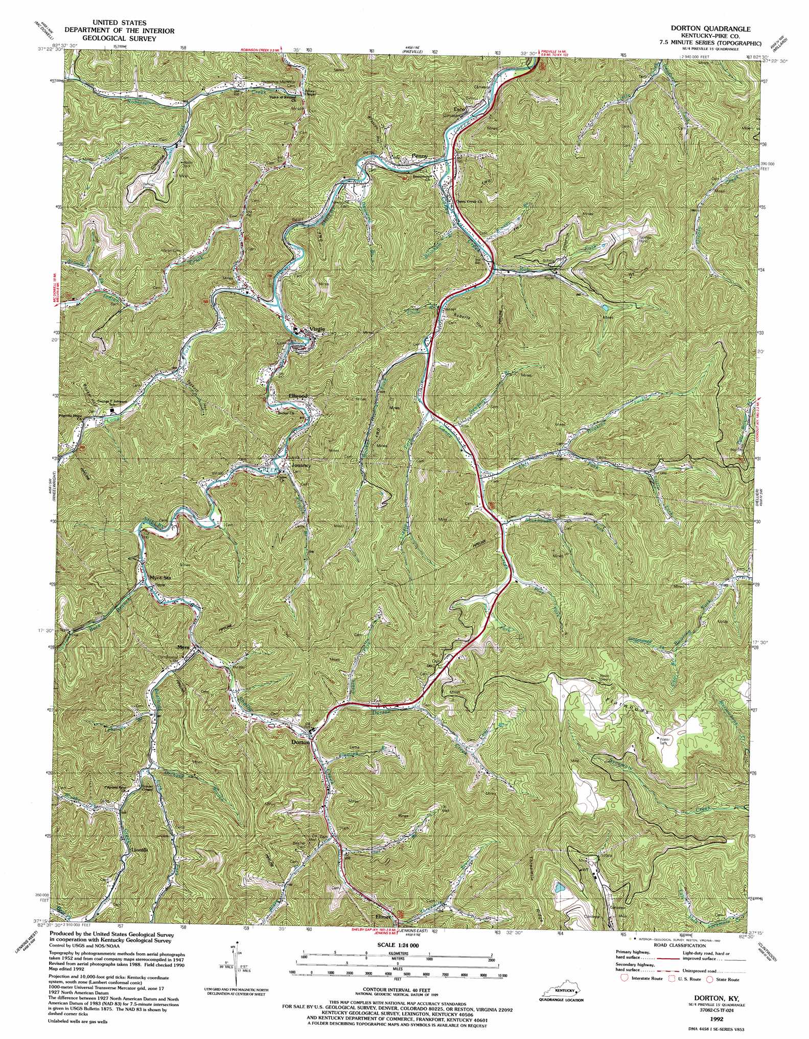
Dorton Topo Map Kentucky
To zoom in, hover over the map of Dorton
USGS Topo Quad 37082c5 - 1:24,000 scale
| Topo Map Name: | Dorton |
| USGS Topo Quad ID: | 37082c5 |
| Print Size: | ca. 21 1/4" wide x 27" high |
| Southeast Coordinates: | 37.25° N latitude / 82.5° W longitude |
| Map Center Coordinates: | 37.3125° N latitude / 82.5625° W longitude |
| U.S. State: | KY |
| Filename: | o37082c5.jpg |
| Download Map JPG Image: | Dorton topo map 1:24,000 scale |
| Map Type: | Topographic |
| Topo Series: | 7.5´ |
| Map Scale: | 1:24,000 |
| Source of Map Images: | United States Geological Survey (USGS) |
| Alternate Map Versions: |
Dorton KY 1954, updated 1955 Download PDF Buy paper map Dorton KY 1954, updated 1965 Download PDF Buy paper map Dorton KY 1954, updated 1978 Download PDF Buy paper map Dorton KY 1992, updated 1992 Download PDF Buy paper map Dorton KY 2010 Download PDF Buy paper map Dorton KY 2013 Download PDF Buy paper map Dorton KY 2016 Download PDF Buy paper map |
1:24,000 Topo Quads surrounding Dorton
Martin |
Harold |
Broad Bottom |
Meta |
Belfry |
Wayland |
Mcdowell |
Pikeville |
Millard |
Lick Creek |
Kite |
Wheelwright |
Dorton |
Hellier |
Elkhorn City |
Mayking |
Jenkins West |
Jenkins East |
Clintwood |
Haysi |
Whitesburg |
Flat Gap |
Pound |
Caney Ridge |
Nora |
> Back to 37082a1 at 1:100,000 scale
> Back to 37082a1 at 1:250,000 scale
> Back to U.S. Topo Maps home
Dorton topo map: Gazetteer
Dorton: Areas
Flatwoods elevation 751m 2463′Dorton: Gaps
Indian Gap elevation 322m 1056′Dorton: Populated Places
Big Card elevation 329m 1079′Dorton elevation 312m 1023′
Elimer elevation 363m 1190′
Ellwood elevation 287m 941′
Esco elevation 234m 767′
Frogtown elevation 265m 869′
Jonancy elevation 289m 948′
Lionilli elevation 323m 1059′
Long Fork elevation 332m 1089′
Myra elevation 293m 961′
Penny elevation 241m 790′
Virgie elevation 275m 902′
Dorton: Post Offices
Beatrice Post Office (historical) elevation 285m 935′Dameron Post Office (historical) elevation 298m 977′
Dorton Post Office elevation 310m 1017′
Esco Post Office (historical) elevation 243m 797′
Jonancy Post Office (historical) elevation 293m 961′
Lionille Post Office (historical) elevation 322m 1056′
Penny Post Office (historical) elevation 343m 1125′
Stewart Post Office (historical) elevation 338m 1108′
Dorton: Ridges
Threemile Ridge elevation 718m 2355′Dorton: Streams
Adkins Branch elevation 255m 836′Andy Akers Branch elevation 312m 1023′
Arnold Fork elevation 297m 974′
Beefhide Creek elevation 289m 948′
Blaze Branch elevation 325m 1066′
Booker Fork elevation 275m 902′
Branham Branch elevation 250m 820′
Brushy Fork elevation 312m 1023′
Burk Branch elevation 285m 935′
Cabin Fork elevation 330m 1082′
Cane Branch elevation 291m 954′
Caney Creek elevation 243m 797′
Coal Branch elevation 387m 1269′
Coal Branch elevation 461m 1512′
Deadening Fork elevation 303m 994′
Doc Bell Branch elevation 284m 931′
Dorton Creek elevation 310m 1017′
Elswick Branch elevation 270m 885′
Flat Fork elevation 388m 1272′
Fleming Branch elevation 315m 1033′
Hopkins Fork elevation 338m 1108′
Indian Creek elevation 247m 810′
John Ray Branch elevation 283m 928′
Kinney Branch elevation 267m 875′
Left Fork Caney Creek elevation 345m 1131′
Lick Fork elevation 308m 1010′
Little Branch elevation 281m 921′
Little Fork elevation 287m 941′
Little Fork elevation 388m 1272′
Lizzie Fork elevation 314m 1030′
Long Fork elevation 255m 836′
Newsome Branch elevation 313m 1026′
Newsome Branch elevation 244m 800′
Orchard Branch elevation 307m 1007′
Owl Branch elevation 328m 1076′
Phillips Branch elevation 300m 984′
Pig Branch elevation 266m 872′
Pine Fork elevation 366m 1200′
Rob Fork elevation 283m 928′
Rock Fork elevation 294m 964′
Rockhouse Fork elevation 347m 1138′
Stagerweed Fork elevation 462m 1515′
Sycamore Fork elevation 395m 1295′
Threemile Branch elevation 352m 1154′
Trace Fork elevation 353m 1158′
Dorton: Summits
Sheep Cliff elevation 728m 2388′Dorton: Valleys
Booker Hollow elevation 288m 944′Bratten Hollow elevation 267m 875′
John Greer Hollow elevation 313m 1026′
Roberts Hollow elevation 312m 1023′
Tackett Hollow elevation 289m 948′
Dorton digital topo map on disk
Buy this Dorton topo map showing relief, roads, GPS coordinates and other geographical features, as a high-resolution digital map file on DVD:
Western Virginia & Southern West Virginia
Buy digital topo maps: Western Virginia & Southern West Virginia