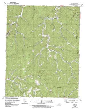
Kite Topo Map Kentucky
To zoom in, hover over the map of Kite
USGS Topo Quad 37082c7 - 1:24,000 scale
| Topo Map Name: | Kite |
| USGS Topo Quad ID: | 37082c7 |
| Print Size: | ca. 21 1/4" wide x 27" high |
| Southeast Coordinates: | 37.25° N latitude / 82.75° W longitude |
| Map Center Coordinates: | 37.3125° N latitude / 82.8125° W longitude |
| U.S. State: | KY |
| Filename: | o37082c7.jpg |
| Download Map JPG Image: | Kite topo map 1:24,000 scale |
| Map Type: | Topographic |
| Topo Series: | 7.5´ |
| Map Scale: | 1:24,000 |
| Source of Map Images: | United States Geological Survey (USGS) |
| Alternate Map Versions: |
Kite KY 1954, updated 1956 Download PDF Buy paper map Kite KY 1954, updated 1968 Download PDF Buy paper map Kite KY 1954, updated 1978 Download PDF Buy paper map Kite KY 1992, updated 1992 Download PDF Buy paper map Kite KY 2010 Download PDF Buy paper map Kite KY 2013 Download PDF Buy paper map Kite KY 2016 Download PDF Buy paper map |
1:24,000 Topo Quads surrounding Kite
> Back to 37082a1 at 1:100,000 scale
> Back to 37082a1 at 1:250,000 scale
> Back to U.S. Topo Maps home
Kite topo map: Gazetteer
Kite: Flats
Hemp Patch Bottom (historical) elevation 275m 902′Kite: Gaps
Beaver Gap elevation 441m 1446′Kite: Populated Places
Drew elevation 387m 1269′Dry Creek elevation 326m 1069′
Hall elevation 302m 990′
Hollybush elevation 297m 974′
Kite elevation 273m 895′
Martinsville elevation 436m 1430′
May elevation 349m 1145′
Nealy elevation 378m 1240′
Omaha elevation 382m 1253′
Pippa Passes elevation 302m 990′
Puncheon elevation 301m 987′
Sylvester (historical) elevation 448m 1469′
Kite: Post Offices
Amazon Post Office (historical) elevation 374m 1227′Carson Post Office (historical) elevation 507m 1663′
Drew Post Office (historical) elevation 403m 1322′
Dry Creek Post Office (historical) elevation 325m 1066′
Hall Post Office (historical) elevation 300m 984′
Holly Bush Post Office (historical) elevation 280m 918′
Ivan Post Office (historical) elevation 395m 1295′
Kite Post Office elevation 263m 862′
May Post Office (historical) elevation 349m 1145′
Nealy Post Office (historical) elevation 341m 1118′
Punchean Post Office (historical) elevation 301m 987′
Republican Post Office (historical) elevation 250m 820′
Topmost Post Office elevation 255m 836′
Weissert Post Office (historical) elevation 280m 918′
Kite: Streams
Arnold Fork elevation 304m 997′Bates Branch elevation 278m 912′
Bill D Branch elevation 305m 1000′
Bloomer Branch elevation 266m 872′
Buck Branch elevation 300m 984′
Buffalo Branch elevation 352m 1154′
Buzzer Branch elevation 277m 908′
Calfpen Branch elevation 375m 1230′
Collins Branch elevation 347m 1138′
Cottonpatch Branch elevation 266m 872′
Crager Fork elevation 336m 1102′
Dry Creek elevation 244m 800′
Ellis Lick elevation 321m 1053′
Gauley Branch elevation 266m 872′
Hall Branch elevation 315m 1033′
Hall Branch elevation 265m 869′
Hemppatch Branch elevation 268m 879′
Holbrook Branch elevation 327m 1072′
Hollybush Creek elevation 271m 889′
Isaac Fork elevation 308m 1010′
Joe King Branch elevation 278m 912′
Left Fork Dry Creek elevation 282m 925′
Left Fork Holly Bush Creek elevation 288m 944′
Meadow Branch elevation 374m 1227′
Mullins Branch elevation 263m 862′
Nealy Branch elevation 349m 1145′
Oldhouse Branch elevation 305m 1000′
Oldhouse Creek elevation 267m 875′
Onion Blade Branch elevation 275m 902′
Panther Lick elevation 318m 1043′
Potato Branch elevation 251m 823′
Poundmill Branch elevation 254m 833′
Puncheon Branch elevation 279m 915′
Righthand Fork elevation 303m 994′
Roaring Branch elevation 287m 941′
Rocklick Branch elevation 256m 839′
Ropeworks Branch elevation 361m 1184′
Scip Branch elevation 337m 1105′
Spicewood Branch elevation 315m 1033′
Spring Branch elevation 347m 1138′
West Fork elevation 334m 1095′
Kite: Summits
Trace Mountain elevation 587m 1925′Kite digital topo map on disk
Buy this Kite topo map showing relief, roads, GPS coordinates and other geographical features, as a high-resolution digital map file on DVD:
Western Virginia & Southern West Virginia
Buy digital topo maps: Western Virginia & Southern West Virginia


