Jamboree Topo Map Kentucky
To zoom in, hover over the map of Jamboree
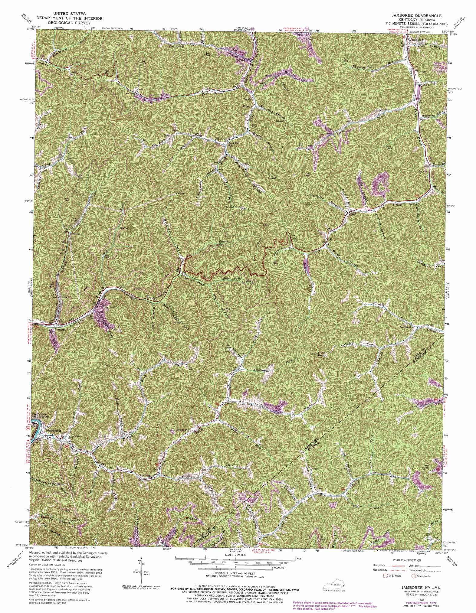
USGS Topo Quad 37082d2 - 1:24,000 scale
| Topo Map Name: | Jamboree |
| USGS Topo Quad ID: | 37082d2 |
| Print Size: | ca. 21 1/4" wide x 27" high |
| Southeast Coordinates: | 37.375° N latitude / 82.125° W longitude |
| Map Center Coordinates: | 37.4375° N latitude / 82.1875° W longitude |
| U.S. States: | KY, VA |
| Filename: | o37082d2.jpg |
| Download Map JPG Image: | Jamboree topo map 1:24,000 scale |
| Map Type: | Topographic |
| Topo Series: | 7.5´ |
| Map Scale: | 1:24,000 |
| Source of Map Images: | United States Geological Survey (USGS) |
| Alternate Map Versions: |
Jamboree KY 1954, updated 1956 Download PDF Buy paper map Jamboree KY 1963, updated 1964 Download PDF Buy paper map Jamboree KY 1963, updated 1978 Download PDF Buy paper map Jamboree KY 2011 Download PDF Buy paper map Jamboree KY 2013 Download PDF Buy paper map Jamboree KY 2016 Download PDF Buy paper map |
1:24,000 Topo Quads surrounding Jamboree
Varney |
Williamson |
Delbarton |
Barnabus |
Man |
Meta |
Belfry |
Matewan |
Majestic |
Wharncliffe |
Millard |
Lick Creek |
Jamboree |
Hurley |
Panther |
Hellier |
Elkhorn City |
Harman |
Grundy |
Patterson |
Clintwood |
Haysi |
Prater |
Vansant |
Keen Mountain |
> Back to 37082a1 at 1:100,000 scale
> Back to 37082a1 at 1:250,000 scale
> Back to U.S. Topo Maps home
Jamboree topo map: Gazetteer
Jamboree: Populated Places
Calloway Branch elevation 366m 1200′Coleman elevation 327m 1072′
Dunlap elevation 263m 862′
Fedscreek elevation 271m 889′
Jamboree elevation 279m 915′
Motley elevation 366m 1200′
Jamboree: Post Offices
Coleman Post Office (historical) elevation 585m 1919′Dunlap Post Office (historical) elevation 300m 984′
Feds Creek Post Office (historical) elevation 249m 816′
Jamboree Post Office (historical) elevation 279m 915′
Jamboree Post Office (historical) elevation 290m 951′
Steele Post Office elevation 328m 1076′
Steele Post Office (historical) elevation 353m 1158′
Steele Post Office (historical) elevation 297m 974′
Jamboree: Streams
Allen Branch elevation 361m 1184′Ash Lick Fork elevation 360m 1181′
Bear Branch elevation 339m 1112′
Bear Branch elevation 383m 1256′
Beech Creek elevation 290m 951′
Big Branch elevation 352m 1154′
Blackberry Fork elevation 418m 1371′
Buckhorn Fork elevation 393m 1289′
Calloway Branch elevation 314m 1030′
Coleman Branch elevation 426m 1397′
Colley Fork elevation 404m 1325′
Cow Branch elevation 266m 872′
Cow Branch elevation 379m 1243′
Dicks Branch elevation 361m 1184′
Dicks Fork elevation 350m 1148′
Dotson Fork elevation 393m 1289′
Dry Fork elevation 257m 843′
Duty Branch elevation 280m 918′
Feds Creek elevation 245m 803′
Gap Fork elevation 369m 1210′
Grassy Branch elevation 382m 1253′
Grassy Fork elevation 365m 1197′
Grassy Spring Branch elevation 322m 1056′
Henroost Fork elevation 373m 1223′
Henry Branch elevation 348m 1141′
Hensley Branch elevation 341m 1118′
Hurricane Fork elevation 349m 1145′
Jones Fork elevation 342m 1122′
King Camp Branch elevation 382m 1253′
Lang Fork elevation 360m 1181′
Laurel Fork elevation 298m 977′
Lee Branch elevation 392m 1286′
Lick Log Fork elevation 322m 1056′
Linn Branch elevation 258m 846′
Low Gap Branch elevation 339m 1112′
Maria Branch elevation 322m 1056′
Miller Branch elevation 298m 977′
Miller Fork elevation 341m 1118′
Motley Fork elevation 269m 882′
Mudlick Fork elevation 315m 1033′
Negro Camp Fork elevation 317m 1040′
Panther Branch elevation 348m 1141′
Peddler Fork elevation 279m 915′
Phillips Branch elevation 280m 918′
Poor Branch elevation 385m 1263′
Prater Branch elevation 315m 1033′
Right Fork Spruce Fork elevation 377m 1236′
Road Fork elevation 315m 1033′
Rockhouse Fork elevation 331m 1085′
Second Big Creek Fork elevation 264m 866′
Shop Branch elevation 353m 1158′
Smith Fork elevation 315m 1033′
Solomon Fork elevation 297m 974′
Spruce Fork elevation 340m 1115′
Spruce Pine Branch elevation 277m 908′
Staggerweed Branch elevation 353m 1158′
Third Fork Big Creek elevation 288m 944′
Turkey Branch elevation 285m 935′
Turkeypen Fork elevation 279m 915′
Turnip Branch elevation 358m 1174′
Wes Lee Fork elevation 402m 1318′
Jamboree: Summits
Hylton Knob elevation 748m 2454′Jamboree: Valleys
Add Hollow elevation 385m 1263′Fox Hollow elevation 276m 905′
Jess Hollow elevation 438m 1437′
Jamboree digital topo map on disk
Buy this Jamboree topo map showing relief, roads, GPS coordinates and other geographical features, as a high-resolution digital map file on DVD:
Western Virginia & Southern West Virginia
Buy digital topo maps: Western Virginia & Southern West Virginia