Delbarton Topo Map West Virginia
To zoom in, hover over the map of Delbarton
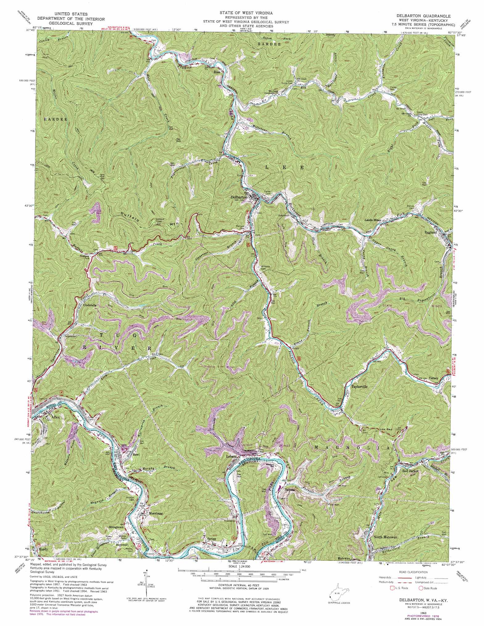
USGS Topo Quad 37082f2 - 1:24,000 scale
| Topo Map Name: | Delbarton |
| USGS Topo Quad ID: | 37082f2 |
| Print Size: | ca. 21 1/4" wide x 27" high |
| Southeast Coordinates: | 37.625° N latitude / 82.125° W longitude |
| Map Center Coordinates: | 37.6875° N latitude / 82.1875° W longitude |
| U.S. States: | WV, KY |
| Filename: | o37082f2.jpg |
| Download Map JPG Image: | Delbarton topo map 1:24,000 scale |
| Map Type: | Topographic |
| Topo Series: | 7.5´ |
| Map Scale: | 1:24,000 |
| Source of Map Images: | United States Geological Survey (USGS) |
| Alternate Map Versions: |
Delbarton WV 1963, updated 1964 Download PDF Buy paper map Delbarton WV 1963, updated 1976 Download PDF Buy paper map Delbarton WV 1963, updated 1978 Download PDF Buy paper map Delbarton WV 2010 Download PDF Buy paper map Delbarton WV 2014 Download PDF Buy paper map Delbarton WV 2016 Download PDF Buy paper map |
1:24,000 Topo Quads surrounding Delbarton
Webb |
Wilsondale |
Trace |
Chapmanville |
Henlawson |
Kermit |
Naugatuck |
Myrtle |
Holden |
Logan |
Varney |
Williamson |
Delbarton |
Barnabus |
Man |
Meta |
Belfry |
Matewan |
Majestic |
Wharncliffe |
Millard |
Lick Creek |
Jamboree |
Hurley |
Panther |
> Back to 37082e1 at 1:100,000 scale
> Back to 37082a1 at 1:250,000 scale
> Back to U.S. Topo Maps home
Delbarton topo map: Gazetteer
Delbarton: Dams
Cinderella Coal Waste Embankment Dam elevation 253m 830′Delbarton: Flats
Phillips Bottom elevation 206m 675′Delbarton: Gaps
Low Gap elevation 373m 1223′Delbarton: Populated Places
Aflex elevation 204m 669′Bias elevation 219m 718′
Burch elevation 224m 734′
Burnwell elevation 216m 708′
Cinderella elevation 255m 836′
Delbarton elevation 233m 764′
Lando Mines elevation 254m 833′
Lobata elevation 210m 688′
Merrimac elevation 224m 734′
North Matewan elevation 221m 725′
Puritan Mines elevation 245m 803′
Ragland elevation 270m 885′
Rawl elevation 216m 708′
Red Jacket elevation 242m 793′
Sprigg elevation 214m 702′
Stringtown elevation 204m 669′
Surosa elevation 218m 715′
Taylorville elevation 264m 866′
Delbarton: Post Offices
Aflex Post Office (historical) elevation 224m 734′Burnwell Post Office (historical) elevation 227m 744′
Lobata Post Office elevation 210m 688′
North Matewan Post Office elevation 220m 721′
Ragland Post Office elevation 270m 885′
Rawl Post Office elevation 206m 675′
Red Jacket Post Office elevation 247m 810′
Sprigg Post Office elevation 216m 708′
Delbarton: Reservoirs
Cinderella Impoundment Number Two elevation 253m 830′Delbarton: Streams
Curry Branch elevation 249m 816′Elk Creek elevation 217m 711′
Ferrell Branch elevation 204m 669′
Ferrell Branch elevation 250m 820′
Fivemile Creek elevation 255m 836′
Hell Creek elevation 211m 692′
Hurricane Creek elevation 238m 780′
Left Fork Elk Creek elevation 269m 882′
Lick Branch elevation 242m 793′
Lick Creek elevation 194m 636′
Lower Stringtown Branch elevation 201m 659′
Maynard Branch elevation 197m 646′
Middle Fork Elk Creek elevation 271m 889′
Millstone Branch elevation 218m 715′
Mitchell Branch elevation 244m 800′
Murphy Branch elevation 195m 639′
Pigeonroost Creek elevation 223m 731′
Right Elk Creek elevation 276m 905′
Rockhouse Fork elevation 226m 741′
Round Bottom Branch elevation 198m 649′
Rutherford Branch elevation 230m 754′
Slate Branch elevation 240m 787′
South Branch Rockhouse Fork elevation 280m 918′
Sprouse Creek elevation 202m 662′
Stonecoal Branch elevation 233m 764′
Sycamore Creek elevation 194m 636′
Upper Curry Branch elevation 250m 820′
Upper Stringtown Branch elevation 200m 656′
Williamson Branch elevation 200m 656′
Delbarton: Summits
Buffalo Mountain elevation 578m 1896′Delbarton: Valleys
Buzzard Roost Hollow elevation 204m 669′Churchouse Hollow elevation 217m 711′
Culler Hollow elevation 220m 721′
Phillips Hollow elevation 209m 685′
Delbarton digital topo map on disk
Buy this Delbarton topo map showing relief, roads, GPS coordinates and other geographical features, as a high-resolution digital map file on DVD:
Western Virginia & Southern West Virginia
Buy digital topo maps: Western Virginia & Southern West Virginia