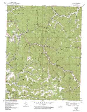
Ivyton Topo Map Kentucky
To zoom in, hover over the map of Ivyton
USGS Topo Quad 37082f8 - 1:24,000 scale
| Topo Map Name: | Ivyton |
| USGS Topo Quad ID: | 37082f8 |
| Print Size: | ca. 21 1/4" wide x 27" high |
| Southeast Coordinates: | 37.625° N latitude / 82.875° W longitude |
| Map Center Coordinates: | 37.6875° N latitude / 82.9375° W longitude |
| U.S. State: | KY |
| Filename: | o37082f8.jpg |
| Download Map JPG Image: | Ivyton topo map 1:24,000 scale |
| Map Type: | Topographic |
| Topo Series: | 7.5´ |
| Map Scale: | 1:24,000 |
| Source of Map Images: | United States Geological Survey (USGS) |
| Alternate Map Versions: |
Ivyton KY 1953, updated 1955 Download PDF Buy paper map Ivyton KY 1962, updated 1964 Download PDF Buy paper map Ivyton KY 1992, updated 1992 Download PDF Buy paper map Ivyton KY 2010 Download PDF Buy paper map Ivyton KY 2013 Download PDF Buy paper map Ivyton KY 2016 Download PDF Buy paper map |
1:24,000 Topo Quads surrounding Ivyton
> Back to 37082e1 at 1:100,000 scale
> Back to 37082a1 at 1:250,000 scale
> Back to U.S. Topo Maps home
Ivyton topo map: Gazetteer
Ivyton: Populated Places
Brainard elevation 216m 708′Dobson elevation 201m 659′
Galdia elevation 284m 931′
Gapville elevation 289m 948′
Gypsy elevation 297m 974′
Ivyton elevation 300m 984′
Marshallville elevation 290m 951′
Riceville elevation 213m 698′
Swamp Branch elevation 222m 728′
Ivyton: Post Offices
Allen Post Office (historical) elevation 299m 980′Conley Post Office (historical) elevation 287m 941′
Elm Post Office (historical) elevation 287m 941′
Galdia Post Office (historical) elevation 292m 958′
Gapville Post Office (historical) elevation 308m 1010′
Ivyton Post Office (historical) elevation 293m 961′
Marshallville Post Office (historical) elevation 287m 941′
Ody Post Office (historical) elevation 315m 1033′
Wireman Post Office elevation 288m 944′
Ivyton: Streams
Alum Rock Branch elevation 298m 977′Bear Branch elevation 251m 823′
Beartree Fork elevation 303m 994′
Big Branch elevation 268m 879′
Big Lick Branch elevation 255m 836′
Blaze Branch elevation 291m 954′
Bobs Branch elevation 301m 987′
Brushy Branch elevation 223m 731′
Brushy Fork elevation 277m 908′
Bullmire Branch elevation 278m 912′
Cane Branch elevation 267m 875′
Cole Branch elevation 234m 767′
Dotson Branch elevation 279m 915′
Dry Bread Fork elevation 276m 905′
Dutton Branch elevation 275m 902′
Fitch Lick Branch elevation 239m 784′
Greasy Branch elevation 215m 705′
Greenrock Fork elevation 208m 682′
Holbrook Branch elevation 219m 718′
Jake Fork elevation 276m 905′
Kelly Branch elevation 287m 941′
Lick Branch elevation 287m 941′
Lick Branch elevation 287m 941′
Limestone Branch elevation 271m 889′
Linecamp Branch elevation 303m 994′
Long Fork elevation 235m 770′
Meredith Branch elevation 286m 938′
Mill Creek elevation 201m 659′
Narrows Fork elevation 245m 803′
Oldhouse Branch elevation 218m 715′
Pigpen Branch elevation 286m 938′
Poe Branch elevation 291m 954′
Pound Branch elevation 288m 944′
Prater Branch elevation 211m 692′
Rice Branch elevation 239m 784′
Richardson Branch elevation 205m 672′
Risner Branch elevation 291m 954′
Rocklick Fork elevation 273m 895′
Salt Lick Branch elevation 288m 944′
Shonny Branch elevation 279m 915′
State Road Fork elevation 237m 777′
Stonecoal Branch elevation 280m 918′
Stony Branch elevation 228m 748′
Swamp Branch elevation 201m 659′
Wolf Branch elevation 255m 836′
Ivyton: Valleys
Coon Hollow elevation 305m 1000′Ivyton digital topo map on disk
Buy this Ivyton topo map showing relief, roads, GPS coordinates and other geographical features, as a high-resolution digital map file on DVD:
Western Virginia & Southern West Virginia
Buy digital topo maps: Western Virginia & Southern West Virginia


