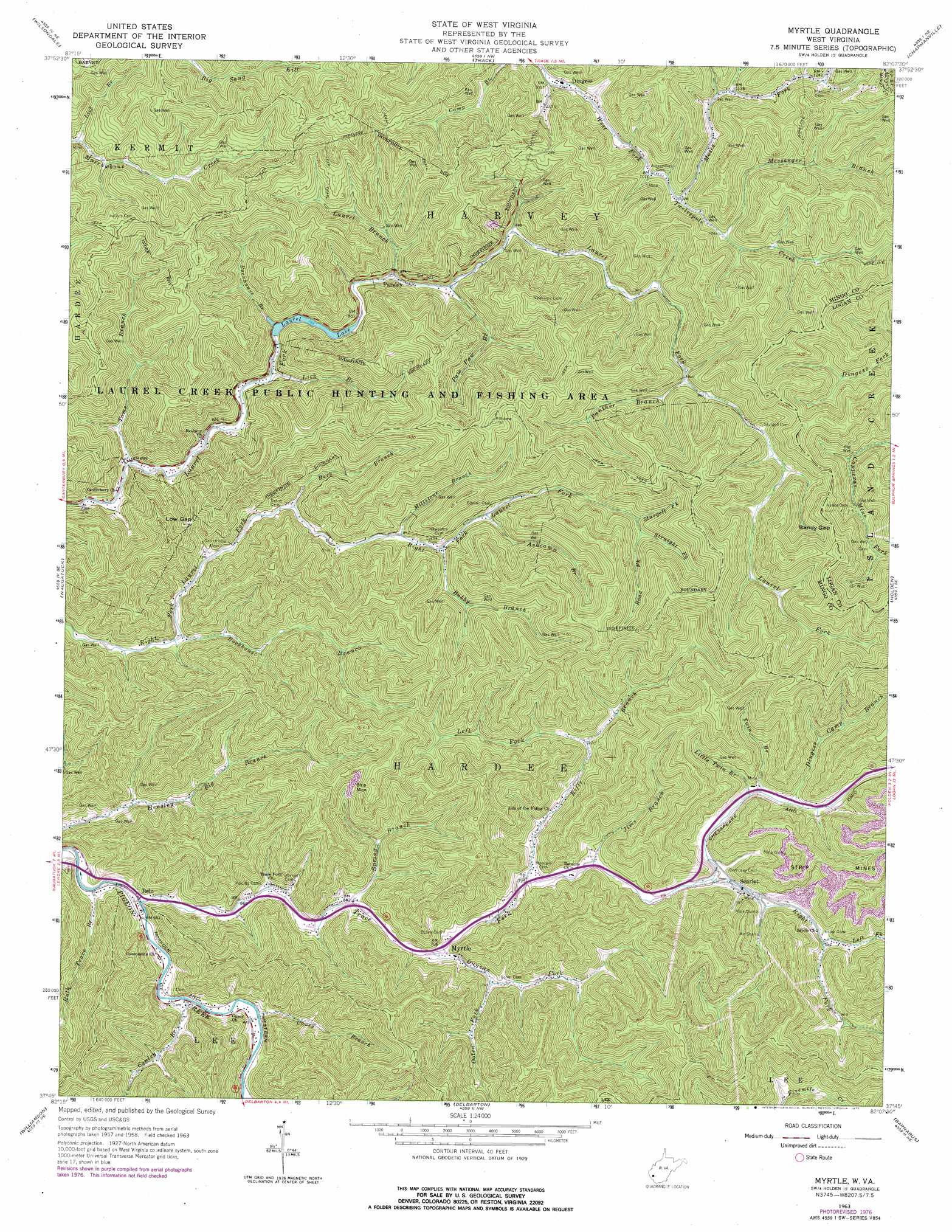
Myrtle Topo Map West Virginia
To zoom in, hover over the map of Myrtle
USGS Topo Quad 37082g2 - 1:24,000 scale
| Topo Map Name: | Myrtle |
| USGS Topo Quad ID: | 37082g2 |
| Print Size: | ca. 21 1/4" wide x 27" high |
| Southeast Coordinates: | 37.75° N latitude / 82.125° W longitude |
| Map Center Coordinates: | 37.8125° N latitude / 82.1875° W longitude |
| U.S. State: | WV |
| Filename: | o37082g2.jpg |
| Download Map JPG Image: | Myrtle topo map 1:24,000 scale |
| Map Type: | Topographic |
| Topo Series: | 7.5´ |
| Map Scale: | 1:24,000 |
| Source of Map Images: | United States Geological Survey (USGS) |
| Alternate Map Versions: |
Myrtle WV 1963, updated 1964 Download PDF Buy paper map Myrtle WV 1963, updated 1977 Download PDF Buy paper map Myrtle WV 1996, updated 2003 Download PDF Buy paper map Myrtle WV 2010 Download PDF Buy paper map Myrtle WV 2014 Download PDF Buy paper map Myrtle WV 2016 Download PDF Buy paper map |
1:24,000 Topo Quads surrounding Myrtle
Radnor |
Kiahsville |
Ranger |
Big Creek |
Mud |
Webb |
Wilsondale |
Trace |
Chapmanville |
Henlawson |
Kermit |
Naugatuck |
Myrtle |
Holden |
Logan |
Varney |
Williamson |
Delbarton |
Barnabus |
Man |
Meta |
Belfry |
Matewan |
Majestic |
Wharncliffe |
> Back to 37082e1 at 1:100,000 scale
> Back to 37082a1 at 1:250,000 scale
> Back to U.S. Topo Maps home
Myrtle topo map: Gazetteer
Myrtle: Dams
Laurel Lake Dam elevation 301m 987′Myrtle: Gaps
Low Gap elevation 299m 980′Sandy Gap elevation 455m 1492′
Myrtle: Parks
Laurel Creek State Wildlife Management Area elevation 447m 1466′Laurel Lake Wildlife Management Area elevation 435m 1427′
Myrtle: Populated Places
Belo elevation 202m 662′Dingess elevation 296m 971′
Myrtle elevation 220m 721′
Parsley elevation 261m 856′
Scarlet elevation 251m 823′
Myrtle: Post Offices
Dingess Post Office elevation 297m 974′Myrtle Post Office elevation 225m 738′
Myrtle: Reservoirs
Laurel Lake elevation 244m 800′Myrtle: Streams
Ashcamp Branch elevation 275m 902′Bubby Branch elevation 263m 862′
Buck Branch elevation 237m 777′
Caney Branch elevation 204m 669′
Conley Branch elevation 200m 656′
Dingess Camp Branch elevation 266m 872′
Duncan Fork elevation 213m 698′
Jims Branch elevation 232m 761′
Laurel Branch elevation 245m 803′
Left Fork Riffe Branch elevation 251m 823′
Left Fork Right Fork Trace Fork elevation 273m 895′
Lick Branch elevation 226m 741′
Lick Branch elevation 287m 941′
Little Twin Branch elevation 269m 882′
Messenger Branch elevation 323m 1059′
Millstone Branch elevation 256m 839′
Moses Fork elevation 313m 1026′
Ooten Fork elevation 228m 748′
Panther Branch elevation 292m 958′
Paw Paw Branch elevation 250m 820′
Riffe Branch elevation 229m 751′
Right Fork Trace Fork elevation 243m 797′
Rockhouse Branch elevation 214m 702′
Rockhouse Branch elevation 240m 787′
Rodd Fork elevation 329m 1079′
Ruth Trace Branch elevation 201m 659′
Spring Branch elevation 209m 685′
Straight Fork elevation 329m 1079′
Sturgell Fork elevation 322m 1056′
Toms Branch elevation 211m 692′
Trace Fork elevation 209m 685′
Twin Branch elevation 262m 859′
Myrtle digital topo map on disk
Buy this Myrtle topo map showing relief, roads, GPS coordinates and other geographical features, as a high-resolution digital map file on DVD:
Western Virginia & Southern West Virginia
Buy digital topo maps: Western Virginia & Southern West Virginia