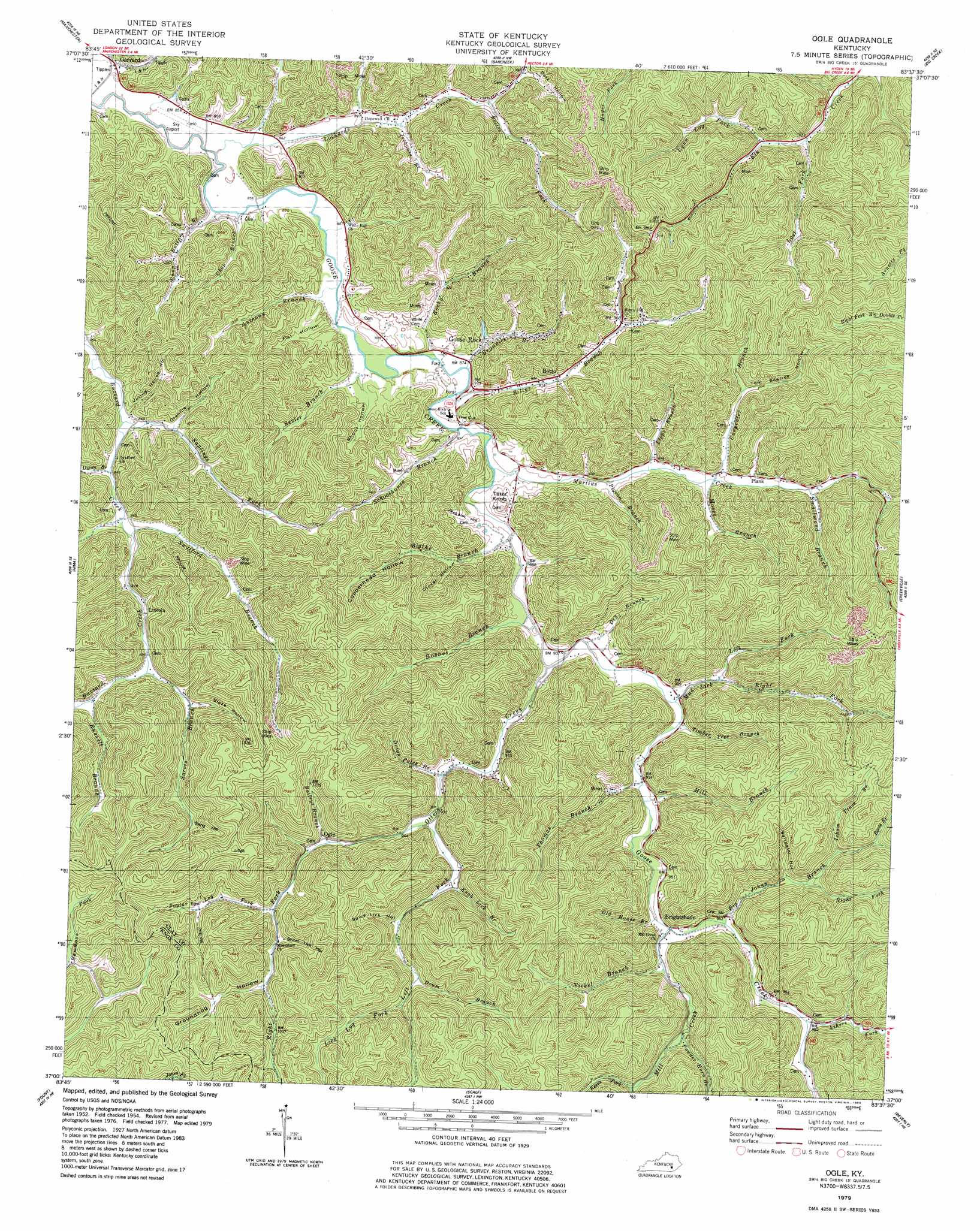
Ogle Topo Map Kentucky
To zoom in, hover over the map of Ogle
USGS Topo Quad 37083a6 - 1:24,000 scale
| Topo Map Name: | Ogle |
| USGS Topo Quad ID: | 37083a6 |
| Print Size: | ca. 21 1/4" wide x 27" high |
| Southeast Coordinates: | 37° N latitude / 83.625° W longitude |
| Map Center Coordinates: | 37.0625° N latitude / 83.6875° W longitude |
| U.S. State: | KY |
| Filename: | o37083a6.jpg |
| Download Map JPG Image: | Ogle topo map 1:24,000 scale |
| Map Type: | Topographic |
| Topo Series: | 7.5´ |
| Map Scale: | 1:24,000 |
| Source of Map Images: | United States Geological Survey (USGS) |
| Alternate Map Versions: |
Ogle KY 1954, updated 1955 Download PDF Buy paper map Ogle KY 1954, updated 1971 Download PDF Buy paper map Ogle KY 1979, updated 1980 Download PDF Buy paper map Ogle KY 2011 Download PDF Buy paper map Ogle KY 2013 Download PDF Buy paper map Ogle KY 2016 Download PDF Buy paper map |
| FStopo: | US Forest Service topo Ogle is available: Download FStopo PDF Download FStopo TIF |
1:24,000 Topo Quads surrounding Ogle
Tyner |
Maulden |
Oneida |
Mistletoe |
Buckhorn |
Portersburg |
Manchester |
Barcreek |
Big Creek |
Hyden West |
Blackwater |
Hima |
Ogle |
Creekville |
Hoskinston |
Heidrick |
Fount |
Scalf |
Beverly |
Helton |
Barbourville |
Artemus |
Pineville |
Balkan |
Wallins Creek |
> Back to 37083a1 at 1:100,000 scale
> Back to 37082a1 at 1:250,000 scale
> Back to U.S. Topo Maps home
Ogle topo map: Gazetteer
Ogle: Airports
Sky Airport elevation 262m 859′Ogle: Bends
The Cut elevation 283m 928′Ogle: Gaps
Dog Gap elevation 358m 1174′Elk Gap elevation 422m 1384′
Ogle: Populated Places
Botto elevation 284m 931′Brightshade elevation 289m 948′
Garrard elevation 264m 866′
Goose Rock elevation 281m 921′
Lincoln elevation 279m 915′
Ogle elevation 303m 994′
Plank elevation 304m 997′
Ogle: Post Offices
Bluehole Post Office (historical) elevation 264m 866′Botto Post Office (historical) elevation 284m 931′
Bright Shade Post Office (historical) elevation 273m 895′
Goose Rock Post Office elevation 269m 882′
Lincoln Post Office (historical) elevation 275m 902′
Lipps Post Office (historical) elevation 278m 912′
Lockards Post Office (historical) elevation 267m 875′
Ogle Post Office (historical) elevation 288m 944′
Plank Post Office (historical) elevation 308m 1010′
Wages Post Office (historical) elevation 313m 1026′
Willowdale Post Office (historical) elevation 262m 859′
Ogle: Streams
Antony Branch elevation 260m 853′Ashers Fork elevation 297m 974′
Baileys Branch elevation 297m 974′
Belles Fork elevation 295m 967′
Big Johns Branch elevation 288m 944′
Billys Branch elevation 268m 879′
Blythe Branch elevation 267m 875′
Boones Branch elevation 268m 879′
Boots Branch elevation 340m 1115′
Buzzard Creek elevation 263m 862′
Carpenter Branch elevation 279m 915′
Chap Branch elevation 265m 869′
Chop Bottom Branch elevation 263m 862′
Dixon Branch elevation 261m 856′
Drum Branch elevation 330m 1082′
Dry Branch elevation 269m 882′
Grannies Branch elevation 266m 872′
Hubbards Fork elevation 340m 1115′
Icehouse Branch elevation 277m 908′
Isham Trace Branch elevation 340m 1115′
Keens Fork elevation 337m 1105′
Knob Lick Branch elevation 296m 971′
Left Fork Mud Lick elevation 286m 938′
Left Fork Otter Creek elevation 280m 918′
Lick Log Fork elevation 337m 1105′
Lipps Branch elevation 275m 902′
Lockards Creek elevation 256m 839′
Lost Fork elevation 312m 1023′
Lynn Lick Fork elevation 323m 1059′
Martins Creek elevation 265m 869′
Mill Branch elevation 277m 908′
Mill Creek elevation 284m 931′
Moses Branch elevation 279m 915′
Mud Lick elevation 286m 938′
Nickel Branch elevation 287m 941′
Old House Branch elevation 280m 918′
Onion Patch Branch elevation 280m 918′
Otter Creek elevation 268m 879′
Pigeon Branch elevation 271m 889′
Poplar Log Fork elevation 310m 1017′
Powder Horn Branch elevation 309m 1013′
Right Fork Big Johns Creek elevation 315m 1033′
Right Fork Mud Lick elevation 286m 938′
Right Fork Otter Creek elevation 280m 918′
Rocky Branch elevation 262m 859′
Russell Branch elevation 274m 898′
Saplings Fork elevation 261m 856′
Sarvis Branch elevation 290m 951′
Schoolhouse Branch elevation 265m 869′
Sevier Branch elevation 265m 869′
Shop Bottom Branch elevation 256m 839′
Smallwood Branch elevation 303m 994′
Swafford Branch elevation 262m 859′
Thomas Branch elevation 280m 918′
Timber Tree Branch elevation 273m 895′
Ogle: Summits
Tater Knob elevation 317m 1040′Walker Knob elevation 514m 1686′
Ogle: Valleys
Blaze Hollow elevation 295m 967′Clover Hollow elevation 291m 954′
Copperhead Hollow elevation 298m 977′
Dark Hollow elevation 302m 990′
Flat Hollow elevation 262m 859′
Grannie Hollow elevation 276m 905′
Groundhog Hollow elevation 324m 1062′
Henry Hollow elevation 340m 1115′
Jackson Hollow elevation 274m 898′
Saltpeter Hollow elevation 328m 1076′
Seng Hollow elevation 330m 1082′
Shoot Hollow elevation 272m 892′
Short Lick Hollow elevation 325m 1066′
Spice Lick Hollow elevation 311m 1020′
Tom Beetree Hollow elevation 301m 987′
Voting House Hollow elevation 265m 869′
Ogle digital topo map on disk
Buy this Ogle topo map showing relief, roads, GPS coordinates and other geographical features, as a high-resolution digital map file on DVD:
Western Virginia & Southern West Virginia
Buy digital topo maps: Western Virginia & Southern West Virginia