Krypton Topo Map Kentucky
To zoom in, hover over the map of Krypton
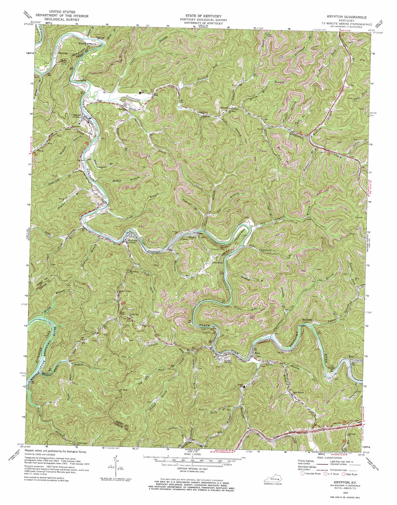
USGS Topo Quad 37083c3 - 1:24,000 scale
| Topo Map Name: | Krypton |
| USGS Topo Quad ID: | 37083c3 |
| Print Size: | ca. 21 1/4" wide x 27" high |
| Southeast Coordinates: | 37.25° N latitude / 83.25° W longitude |
| Map Center Coordinates: | 37.3125° N latitude / 83.3125° W longitude |
| U.S. State: | KY |
| Filename: | o37083c3.jpg |
| Download Map JPG Image: | Krypton topo map 1:24,000 scale |
| Map Type: | Topographic |
| Topo Series: | 7.5´ |
| Map Scale: | 1:24,000 |
| Source of Map Images: | United States Geological Survey (USGS) |
| Alternate Map Versions: |
Krypton KY 1954, updated 1955 Download PDF Buy paper map Krypton KY 1961, updated 1962 Download PDF Buy paper map Krypton KY 1972, updated 1973 Download PDF Buy paper map Krypton KY 2011 Download PDF Buy paper map Krypton KY 2013 Download PDF Buy paper map Krypton KY 2016 Download PDF Buy paper map |
| FStopo: | US Forest Service topo Krypton is available: Download FStopo PDF Download FStopo TIF |
1:24,000 Topo Quads surrounding Krypton
Tallega |
Jackson |
Quicksand |
Guage |
Tiptop |
Cowcreek |
Canoe |
Haddix |
Noble |
Vest |
Mistletoe |
Buckhorn |
Krypton |
Hazard North |
Carrie |
Big Creek |
Hyden West |
Hyden East |
Hazard South |
Vicco |
Creekville |
Hoskinston |
Cutshin |
Leatherwood |
Tilford |
> Back to 37083a1 at 1:100,000 scale
> Back to 37082a1 at 1:250,000 scale
> Back to U.S. Topo Maps home
Krypton topo map: Gazetteer
Krypton: Airports
Duff Airport elevation 241m 790′Krypton: Bars
Fishtrap Shoals elevation 239m 784′Krypton: Bends
Campbell Bend elevation 295m 967′Stidham Bend elevation 241m 790′
Krypton: Bridges
Chavies Bridge elevation 235m 770′Krypton: Gaps
Ivy Gap elevation 409m 1341′Krypton: Populated Places
Barwick elevation 244m 800′Busy elevation 279m 915′
Butterfly elevation 260m 853′
Campbell elevation 249m 816′
Campbell elevation 280m 918′
Chavies elevation 244m 800′
Dunraven elevation 249m 816′
Hurricane elevation 263m 862′
Krypton elevation 248m 813′
Lamont elevation 253m 830′
Lead Branch elevation 244m 800′
Manuel elevation 267m 875′
Mudlick elevation 313m 1026′
Napfor elevation 248m 813′
Olivers elevation 253m 830′
Red Hill elevation 244m 800′
Typo elevation 268m 879′
Yerkes elevation 267m 875′
Krypton: Post Offices
Baker Post Office (historical) elevation 263m 862′Boat Post Office (historical) elevation 243m 797′
Busy Post Office (historical) elevation 248m 813′
Butterfly Post Office (historical) elevation 251m 823′
Chavies Post Office elevation 242m 793′
Confluence Post Office (historical) elevation 257m 843′
Dunraven Post Office (historical) elevation 255m 836′
Glenn Post Office (historical) elevation 239m 784′
Grapevine Post Office (historical) elevation 250m 820′
Lamont Post Office (historical) elevation 254m 833′
Manuel Post Office (historical) elevation 266m 872′
McClure Post Office (historical) elevation 237m 777′
Napfor Post Office (historical) elevation 250m 820′
Typo Post Office (historical) elevation 258m 846′
Yerkes Post Office (historical) elevation 248m 813′
Krypton: Streams
Abes Branch elevation 255m 836′Anderson Branch elevation 241m 790′
Beech Branch elevation 255m 836′
Big Willard Creek elevation 246m 807′
Bills Branch elevation 256m 839′
Bobbin Branch elevation 236m 774′
Briar Fork elevation 269m 882′
Buck Branch elevation 259m 849′
Campbell Creek elevation 244m 800′
Cary Branch elevation 242m 793′
Clear Fork elevation 277m 908′
Colwell Fork elevation 243m 797′
Combs Branch elevation 287m 941′
Combs Branch elevation 237m 777′
Couch Fork elevation 248m 813′
Eversole Creek elevation 235m 770′
First Creek elevation 264m 866′
Fish Trap Branch elevation 244m 800′
Flat Gap Branch elevation 276m 905′
Forked Mouth Creek elevation 298m 977′
Grapevine Creek elevation 235m 770′
Grassy Branch elevation 254m 833′
Groundhog Fork elevation 287m 941′
Gunner Branch elevation 240m 787′
Haddock Fork elevation 243m 797′
Hurricane Branch elevation 262m 859′
Ivy Gap Fork elevation 290m 951′
Jackson Fork elevation 292m 958′
Jake Campbell Branch elevation 243m 797′
Laurel Branch elevation 250m 820′
Laurel Fork elevation 301m 987′
Laurel Fork elevation 266m 872′
Lead Branch elevation 241m 790′
Left Fork Campbell Creek elevation 251m 823′
Left Fork Trace Branch elevation 266m 872′
Lick Branch elevation 239m 784′
Little Willard Creek elevation 252m 826′
Lower Branch elevation 252m 826′
Lower Second Creek elevation 277m 908′
Meadow Branch elevation 243m 797′
Mudlick Branch elevation 294m 964′
Napier Branch elevation 240m 787′
Napier Branch elevation 237m 777′
Oldhouse Branch elevation 239m 784′
Oliver Branch elevation 244m 800′
Pads Branch elevation 288m 944′
Pigeonroost Branch elevation 248m 813′
Right Fork Rockhouse Fork elevation 298m 977′
Right Fork Spencer Creek elevation 249m 816′
Right Fork Trace Branch elevation 267m 875′
Rockhouse Fork elevation 287m 941′
Rocklick Branch elevation 243m 797′
Roseanne Branch elevation 303m 994′
Rye Branch elevation 247m 810′
Sam Campbell Branch elevation 241m 790′
Scalem Branch elevation 237m 777′
Shinglepen Branch elevation 294m 964′
Snatch Creek elevation 286m 938′
Spencer Creek elevation 237m 777′
Stacy Branch elevation 262m 859′
Steve Napier Branch elevation 237m 777′
Stidham Branch elevation 232m 761′
Strong Branch elevation 232m 761′
Sugar Branch elevation 233m 764′
Trace Branch elevation 264m 866′
Two Notch Branch elevation 314m 1030′
Wiley Miller Branch elevation 266m 872′
Krypton: Tunnels
Campbell Tunnel elevation 331m 1085′Line Tunnel elevation 323m 1059′
Typo Tunnel elevation 288m 944′
Yerkes Tunnel elevation 310m 1017′
Krypton digital topo map on disk
Buy this Krypton topo map showing relief, roads, GPS coordinates and other geographical features, as a high-resolution digital map file on DVD:
Western Virginia & Southern West Virginia
Buy digital topo maps: Western Virginia & Southern West Virginia