Tyner Topo Map Kentucky
To zoom in, hover over the map of Tyner
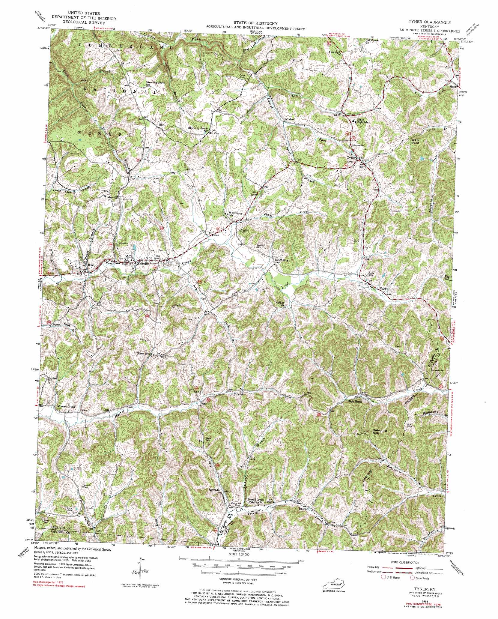
USGS Topo Quad 37083c8 - 1:24,000 scale
| Topo Map Name: | Tyner |
| USGS Topo Quad ID: | 37083c8 |
| Print Size: | ca. 21 1/4" wide x 27" high |
| Southeast Coordinates: | 37.25° N latitude / 83.875° W longitude |
| Map Center Coordinates: | 37.3125° N latitude / 83.9375° W longitude |
| U.S. State: | KY |
| Filename: | o37083c8.jpg |
| Download Map JPG Image: | Tyner topo map 1:24,000 scale |
| Map Type: | Topographic |
| Topo Series: | 7.5´ |
| Map Scale: | 1:24,000 |
| Source of Map Images: | United States Geological Survey (USGS) |
| Alternate Map Versions: |
Tyner KY 1953, updated 1955 Download PDF Buy paper map Tyner KY 1953, updated 1972 Download PDF Buy paper map Tyner KY 1976, updated 1984 Download PDF Buy paper map Tyner KY 2011 Download PDF Buy paper map Tyner KY 2013 Download PDF Buy paper map Tyner KY 2016 Download PDF Buy paper map |
| FStopo: | US Forest Service topo Tyner is available: Download FStopo PDF Download FStopo TIF |
1:24,000 Topo Quads surrounding Tyner
Bighill |
Alcorn |
Leighton |
Heidelberg |
Beattyville |
Johnetta |
Sandgap |
Mckee |
Sturgeon |
Booneville |
Livingston |
Parrot |
Tyner |
Maulden |
Oneida |
Bernstadt |
London |
Portersburg |
Manchester |
Barcreek |
London Sw |
Lily |
Blackwater |
Hima |
Ogle |
> Back to 37083a1 at 1:100,000 scale
> Back to 37082a1 at 1:250,000 scale
> Back to U.S. Topo Maps home
Tyner topo map: Gazetteer
Tyner: Gaps
Swindling Gap elevation 373m 1223′Tyner: Populated Places
Annville elevation 336m 1102′Blooming Grove elevation 373m 1223′
Bond elevation 313m 1026′
Buffalo elevation 316m 1036′
Datha elevation 328m 1076′
Egypt elevation 346m 1135′
Green Hill elevation 352m 1154′
Herd elevation 335m 1099′
High Knob elevation 312m 1023′
Lewis elevation 332m 1089′
Mildred elevation 342m 1122′
Moores Creek elevation 320m 1049′
Olin elevation 406m 1332′
Royrader elevation 315m 1033′
Stringtown elevation 308m 1010′
Tyner elevation 361m 1184′
Welchburg elevation 344m 1128′
Zekes Point elevation 397m 1302′
Tyner: Post Offices
Annville Post Office (historical) elevation 337m 1105′Bond Post Office (historical) elevation 338m 1108′
Cassia Post Office (historical) elevation 343m 1125′
Chinquapin Post Office (historical) elevation 363m 1190′
Datha Post Office (historical) elevation 329m 1079′
Egypt Post Office (historical) elevation 359m 1177′
Herd Post Office (historical) elevation 335m 1099′
High Knob Post Office (historical) elevation 410m 1345′
High Knob Post Office (historical) elevation 308m 1010′
Mildred Post Office (historical) elevation 343m 1125′
Moores Creek Post Office (historical) elevation 317m 1040′
Olin Post Office (historical) elevation 404m 1325′
Pond Creek Post Office (historical) elevation 340m 1115′
Royrader Post Office (historical) elevation 318m 1043′
Tyner Post Office elevation 361m 1184′
Welchburg Post Office (historical) elevation 346m 1135′
Tyner: Streams
Baldwin Branch elevation 309m 1013′Bee Branch elevation 315m 1033′
Big Bottom Branch elevation 310m 1017′
Cave Branch elevation 317m 1040′
Crab Apple Branch elevation 337m 1105′
Devils Den Branch elevation 308m 1010′
Dry Fork elevation 323m 1059′
Flat Lick Creek elevation 323m 1059′
Grassy Branch elevation 342m 1122′
Hazel Branch elevation 313m 1026′
Lewis Branch elevation 306m 1003′
Lost Lick elevation 335m 1099′
Woods Branch elevation 344m 1128′
Zekes Creek elevation 331m 1085′
Tyner: Summits
Yates Knob elevation 422m 1384′Tyner: Valleys
Stringtown Hollow elevation 308m 1010′Tyner digital topo map on disk
Buy this Tyner topo map showing relief, roads, GPS coordinates and other geographical features, as a high-resolution digital map file on DVD:
Western Virginia & Southern West Virginia
Buy digital topo maps: Western Virginia & Southern West Virginia