Haddix Topo Map Kentucky
To zoom in, hover over the map of Haddix
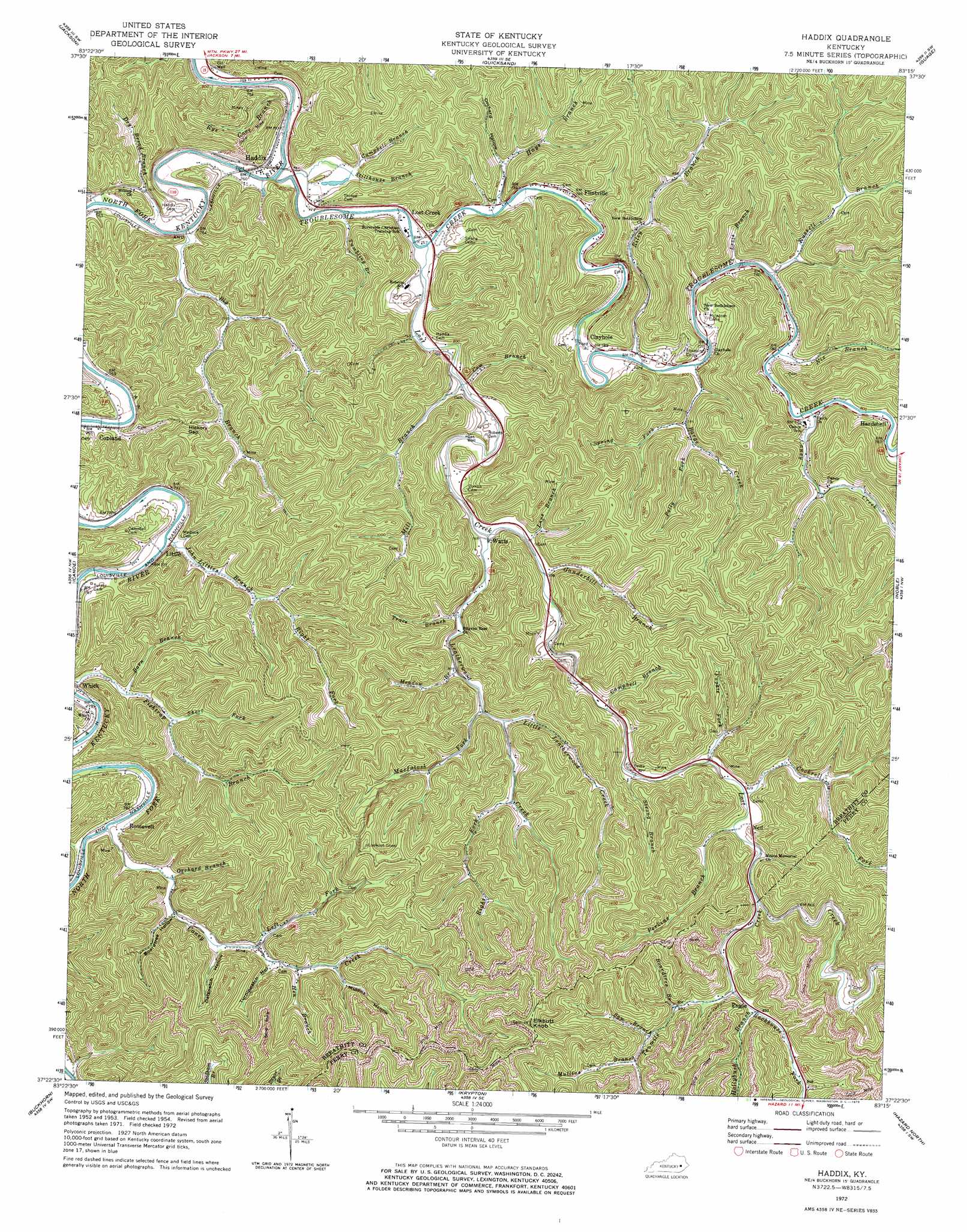
USGS Topo Quad 37083d3 - 1:24,000 scale
| Topo Map Name: | Haddix |
| USGS Topo Quad ID: | 37083d3 |
| Print Size: | ca. 21 1/4" wide x 27" high |
| Southeast Coordinates: | 37.375° N latitude / 83.25° W longitude |
| Map Center Coordinates: | 37.4375° N latitude / 83.3125° W longitude |
| U.S. State: | KY |
| Filename: | o37083d3.jpg |
| Download Map JPG Image: | Haddix topo map 1:24,000 scale |
| Map Type: | Topographic |
| Topo Series: | 7.5´ |
| Map Scale: | 1:24,000 |
| Source of Map Images: | United States Geological Survey (USGS) |
| Alternate Map Versions: |
Haddix KY 1954, updated 1955 Download PDF Buy paper map Haddix KY 1961, updated 1962 Download PDF Buy paper map Haddix KY 1972, updated 1973 Download PDF Buy paper map Haddix KY 2010 Download PDF Buy paper map Haddix KY 2013 Download PDF Buy paper map Haddix KY 2016 Download PDF Buy paper map |
1:24,000 Topo Quads surrounding Haddix
Campton |
Landsaw |
Lee City |
Seitz |
Salyersville South |
Tallega |
Jackson |
Quicksand |
Guage |
Tiptop |
Cowcreek |
Canoe |
Haddix |
Noble |
Vest |
Mistletoe |
Buckhorn |
Krypton |
Hazard North |
Carrie |
Big Creek |
Hyden West |
Hyden East |
Hazard South |
Vicco |
> Back to 37083a1 at 1:100,000 scale
> Back to 37082a1 at 1:250,000 scale
> Back to U.S. Topo Maps home
Haddix topo map: Gazetteer
Haddix: Airports
Wendell H Ford Airport elevation 350m 1148′Haddix: Gaps
Hickory Gap elevation 343m 1125′Haddix: Populated Places
Clayhole elevation 246m 807′Copland elevation 232m 761′
Engle elevation 272m 892′
Flintville elevation 240m 787′
Haddix elevation 238m 780′
Hardshell elevation 240m 787′
Little elevation 236m 774′
Lost Creek elevation 239m 784′
Ned elevation 253m 830′
Roosevelt elevation 240m 787′
Watts elevation 230m 754′
Haddix: Post Offices
Buckhorn Post Office (historical) elevation 338m 1108′Engle Post Office (historical) elevation 314m 1030′
Haddix: Streams
Barge Creek elevation 232m 761′Barn Branch elevation 236m 774′
Big Branch elevation 220m 721′
Broadtree Branch elevation 275m 902′
Campbell Branch elevation 242m 793′
Campbell Branch elevation 225m 738′
Caney Creek elevation 231m 757′
Caney Creek elevation 236m 774′
Cockrell Fork elevation 246m 807′
Cow Branch elevation 228m 748′
Dry Bread Branch elevation 220m 721′
Fishtrap Branch elevation 229m 751′
Fugate Fork elevation 240m 787′
Ganderbill Branch elevation 235m 770′
Hays Branch elevation 223m 731′
Hen Branch elevation 269m 882′
Hollybush Branch elevation 271m 889′
John Littles Branch elevation 229m 751′
Lane Branch elevation 232m 761′
Leatherwood Creek elevation 229m 751′
Left Fork Caney Creek elevation 255m 836′
Levis Branch elevation 230m 754′
Little Leatherwood Creek elevation 252m 826′
Lost Creek elevation 223m 731′
MacIntosh Fork elevation 252m 826′
Meadow Branch elevation 305m 1000′
Mill Branch elevation 227m 744′
Mullins Branch elevation 282m 925′
Nix Branch elevation 238m 780′
Orchard Branch elevation 239m 784′
Perkins Branch elevation 247m 810′
Polly Fork elevation 247m 810′
Right Fork John Littles Branch elevation 247m 810′
Right Fork Leatherwood Creek elevation 268m 879′
Riley Branch elevation 231m 757′
Rockhouse Fork elevation 266m 872′
Russell Branch elevation 229m 751′
Rye Cove Branch elevation 218m 715′
Saw Branch elevation 278m 912′
Short Fork elevation 251m 823′
Spring Fork elevation 237m 777′
Stillhouse Branch elevation 226m 741′
Strong Branch elevation 240m 787′
Tenmile Creek elevation 251m 823′
Trace Branch elevation 240m 787′
Troublesome Creek elevation 218m 715′
Tumbling Branch elevation 219m 718′
Haddix: Summits
Elkbutt Knob elevation 486m 1594′Haddix: Valleys
Broadtree Hollow elevation 243m 797′Mullins Hollow elevation 279m 915′
Oatspatch Hollow elevation 254m 833′
Orchard Hollow elevation 234m 767′
Turnippatch Hollow elevation 266m 872′
Haddix digital topo map on disk
Buy this Haddix topo map showing relief, roads, GPS coordinates and other geographical features, as a high-resolution digital map file on DVD:
Western Virginia & Southern West Virginia
Buy digital topo maps: Western Virginia & Southern West Virginia