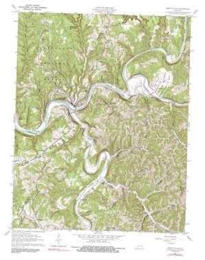
Beattyville Topo Map Kentucky
To zoom in, hover over the map of Beattyville
USGS Topo Quad 37083e6 - 1:24,000 scale
| Topo Map Name: | Beattyville |
| USGS Topo Quad ID: | 37083e6 |
| Print Size: | ca. 21 1/4" wide x 27" high |
| Southeast Coordinates: | 37.5° N latitude / 83.625° W longitude |
| Map Center Coordinates: | 37.5625° N latitude / 83.6875° W longitude |
| U.S. State: | KY |
| Filename: | o37083e6.jpg |
| Download Map JPG Image: | Beattyville topo map 1:24,000 scale |
| Map Type: | Topographic |
| Topo Series: | 7.5´ |
| Map Scale: | 1:24,000 |
| Source of Map Images: | United States Geological Survey (USGS) |
| Alternate Map Versions: |
Beattyville KY 1952, updated 1954 Download PDF Buy paper map Beattyville KY 1961, updated 1963 Download PDF Buy paper map Beattyville KY 1961, updated 1976 Download PDF Buy paper map Beattyville KY 1961, updated 1991 Download PDF Buy paper map Beattyville KY 2011 Download PDF Buy paper map Beattyville KY 2013 Download PDF Buy paper map Beattyville KY 2016 Download PDF Buy paper map |
| FStopo: | US Forest Service topo Beattyville is available: Download FStopo PDF Download FStopo TIF |
1:24,000 Topo Quads surrounding Beattyville
> Back to 37083e1 at 1:100,000 scale
> Back to 37082a1 at 1:250,000 scale
> Back to U.S. Topo Maps home
Beattyville topo map: Gazetteer
Beattyville: Populated Places
Airedale elevation 216m 708′Beattyville elevation 204m 669′
Belle Point elevation 206m 675′
Congleton elevation 287m 941′
Enoch elevation 231m 757′
Fish Creek Neighborhood elevation 260m 853′
Lower Buffalo elevation 208m 682′
Maloney elevation 220m 721′
Mount Olive elevation 338m 1108′
Pebworth elevation 275m 902′
Proctor elevation 251m 823′
Saint Helens elevation 222m 728′
Stacey Neighborhood elevation 244m 800′
Stay elevation 235m 770′
White Ash elevation 203m 666′
Beattyville: Post Offices
Hawk Post Office (historical) elevation 222m 728′Pebworth Post Office elevation 282m 925′
Stacey Post Office (historical) elevation 236m 774′
Beattyville: Streams
Big Branch elevation 195m 639′Blaines Branch elevation 201m 659′
Caney Fork elevation 237m 777′
Crystal Creek elevation 195m 639′
Dirksen Branch elevation 193m 633′
Double Cabin Creek elevation 198m 649′
Dunigan Branch elevation 196m 643′
Hell Creek elevation 197m 646′
Jerushia Branch elevation 223m 731′
Laurel Branch elevation 190m 623′
Log Shoal Branch elevation 194m 636′
Long Branch elevation 193m 633′
Long Shoal Branch elevation 205m 672′
Lower Buffalo Creek elevation 198m 649′
Matton Creek elevation 201m 659′
Middle Fork Kentucky River elevation 202m 662′
Mikes Branch elevation 190m 623′
Mirey Creek elevation 190m 623′
North Fork Kentucky River elevation 190m 623′
Pawpaw Creek elevation 204m 669′
Puncheon Branch elevation 203m 666′
Silver Creek elevation 195m 639′
South Fork Kentucky River elevation 193m 633′
Straight Fork elevation 237m 777′
Sulphur Springs Fork elevation 237m 777′
Threemile Branch elevation 256m 839′
Walker Creek elevation 214m 702′
Beattyville: Valleys
Fox Hollow elevation 214m 702′Mulberry Hollow Valley elevation 210m 688′
Beattyville digital topo map on disk
Buy this Beattyville topo map showing relief, roads, GPS coordinates and other geographical features, as a high-resolution digital map file on DVD:
Western Virginia & Southern West Virginia
Buy digital topo maps: Western Virginia & Southern West Virginia


