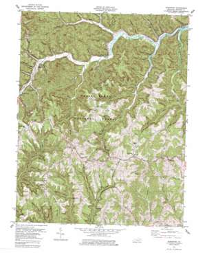
Scranton Topo Map Kentucky
To zoom in, hover over the map of Scranton
USGS Topo Quad 37083h5 - 1:24,000 scale
| Topo Map Name: | Scranton |
| USGS Topo Quad ID: | 37083h5 |
| Print Size: | ca. 21 1/4" wide x 27" high |
| Southeast Coordinates: | 37.875° N latitude / 83.5° W longitude |
| Map Center Coordinates: | 37.9375° N latitude / 83.5625° W longitude |
| U.S. State: | KY |
| Filename: | o37083h5.jpg |
| Download Map JPG Image: | Scranton topo map 1:24,000 scale |
| Map Type: | Topographic |
| Topo Series: | 7.5´ |
| Map Scale: | 1:24,000 |
| Source of Map Images: | United States Geological Survey (USGS) |
| Alternate Map Versions: |
Scranton KY 1952, updated 1953 Download PDF Buy paper map Scranton KY 1952, updated 1967 Download PDF Buy paper map Scranton KY 1979, updated 1979 Download PDF Buy paper map Scranton KY 2011 Download PDF Buy paper map Scranton KY 2013 Download PDF Buy paper map Scranton KY 2016 Download PDF Buy paper map |
| FStopo: | US Forest Service topo Scranton is available: Download FStopo PDF Download FStopo TIF |
1:24,000 Topo Quads surrounding Scranton
> Back to 37083e1 at 1:100,000 scale
> Back to 37082a1 at 1:250,000 scale
> Back to U.S. Topo Maps home
Scranton topo map: Gazetteer
Scranton: Populated Places
Botts elevation 338m 1108′Denniston elevation 337m 1105′
Hill Top elevation 344m 1128′
Laurel Grove elevation 391m 1282′
Mariba elevation 358m 1174′
McCausey Ridge elevation 397m 1302′
Ratliff elevation 255m 836′
Scranton elevation 241m 790′
Trimble Bend elevation 335m 1099′
Wellington elevation 364m 1194′
West Denniston elevation 277m 908′
Scranton: Post Offices
Denniston Post Office elevation 340m 1115′Mariba Post Office (historical) elevation 360m 1181′
McCausey Post Office (historical) elevation 384m 1259′
Scranton Post Office (historical) elevation 239m 784′
Wellington Post Office elevation 365m 1197′
Scranton: Ridges
Betty Gap Ridge elevation 369m 1210′Corner Ridge elevation 378m 1240′
Fletcher Ridge elevation 366m 1200′
Kendrick Ridge elevation 356m 1167′
Tarr Ridge elevation 397m 1302′
Scranton: Streams
Auger Hole Branch elevation 280m 918′Blythes Branch elevation 262m 859′
Board Cut Branch elevation 220m 721′
Botts Fork elevation 244m 800′
Brier Branch elevation 234m 767′
Brushy Fork elevation 220m 721′
Clifton Creek elevation 237m 777′
Green Gose Branch elevation 266m 872′
Hackney Branch elevation 250m 820′
Halfway Branch elevation 243m 797′
Hog Branch elevation 237m 777′
Holland Branch elevation 240m 787′
Jim Branch elevation 234m 767′
Josie Branch elevation 280m 918′
Kinster Branch elevation 220m 721′
Landsaw Branch elevation 271m 889′
Lawson Branch elevation 284m 931′
Long Branch elevation 244m 800′
Mariba Fork elevation 271m 889′
Meyers Fork elevation 227m 744′
Owens Branch elevation 260m 853′
Ponder Branch elevation 254m 833′
Ratliff Creek elevation 229m 751′
Richardson Branch elevation 257m 843′
Slab Camp Branch elevation 226m 741′
Suiters Branch elevation 252m 826′
Thomas Branch elevation 232m 761′
Tolan Creek elevation 256m 839′
Trace Branch elevation 250m 820′
Welch Fork elevation 250m 820′
Wynn Branch elevation 273m 895′
Scranton: Summits
Craig Hill elevation 360m 1181′Donathan Rock elevation 353m 1158′
Scranton: Valleys
Becky Jane Hollow elevation 281m 921′Big Oak Hollow elevation 243m 797′
Brewer Hollow elevation 232m 761′
Cubilo Hollow elevation 265m 869′
Dock Hollow elevation 265m 869′
Hall Hollow elevation 256m 839′
Kendrick Hollow elevation 249m 816′
Morgan Hollow elevation 251m 823′
Simpkins Hollow elevation 259m 849′
Taylor Hollow elevation 239m 784′
Wagers Hollow elevation 228m 748′
Scranton digital topo map on disk
Buy this Scranton topo map showing relief, roads, GPS coordinates and other geographical features, as a high-resolution digital map file on DVD:
Western Virginia & Southern West Virginia
Buy digital topo maps: Western Virginia & Southern West Virginia


