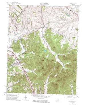
Levee Topo Map Kentucky
To zoom in, hover over the map of Levee
USGS Topo Quad 37083h8 - 1:24,000 scale
| Topo Map Name: | Levee |
| USGS Topo Quad ID: | 37083h8 |
| Print Size: | ca. 21 1/4" wide x 27" high |
| Southeast Coordinates: | 37.875° N latitude / 83.875° W longitude |
| Map Center Coordinates: | 37.9375° N latitude / 83.9375° W longitude |
| U.S. State: | KY |
| Filename: | o37083h8.jpg |
| Download Map JPG Image: | Levee topo map 1:24,000 scale |
| Map Type: | Topographic |
| Topo Series: | 7.5´ |
| Map Scale: | 1:24,000 |
| Source of Map Images: | United States Geological Survey (USGS) |
| Alternate Map Versions: |
Levee KY 1950, updated 1954 Download PDF Buy paper map Levee KY 1952, updated 1954 Download PDF Buy paper map Levee KY 1965, updated 1966 Download PDF Buy paper map Levee KY 2010 Download PDF Buy paper map Levee KY 2013 Download PDF Buy paper map Levee KY 2016 Download PDF Buy paper map |
1:24,000 Topo Quads surrounding Levee
> Back to 37083e1 at 1:100,000 scale
> Back to 37082a1 at 1:250,000 scale
> Back to U.S. Topo Maps home
Levee topo map: Gazetteer
Levee: Mines
White Rock Quarry elevation 403m 1322′Levee: Parks
Spencer Morton Preserve elevation 416m 1364′Levee: Populated Places
Black Creek elevation 208m 682′Camargo elevation 281m 921′
Kiddville elevation 247m 810′
Levee elevation 242m 793′
New Providence elevation 226m 741′
Paint Creek elevation 207m 679′
Trimble elevation 280m 918′
Virden elevation 207m 679′
Westbend elevation 226m 741′
Levee: Post Offices
Camargo Post Office (historical) elevation 282m 925′Indian Fields Post Office (historical) elevation 226m 741′
Kiddville Post Office (historical) elevation 247m 810′
Levee Post Office (historical) elevation 242m 793′
Virden Post Office (historical) elevation 206m 675′
Westbend Post Office (historical) elevation 225m 738′
Levee: Reservoirs
Oldham Pond elevation 251m 823′Levee: Ridges
Barlow Ridge elevation 281m 921′Levee: Streams
Bowles Branch elevation 243m 797′Bowling Fork elevation 246m 807′
Brushy Lick Fork elevation 219m 718′
Combs Branch elevation 233m 764′
Cooperas Creek elevation 206m 675′
Cream Alley Branch elevation 242m 793′
Crooked Ash Branch elevation 263m 862′
Dry Branch elevation 249m 816′
Falls Branch elevation 188m 616′
Hardwicks Branch elevation 246m 807′
Hog Creek elevation 242m 793′
Indian Old Fields Branch elevation 223m 731′
North Branch Lulbegrud Creek elevation 227m 744′
Oil Springs Branch elevation 217m 711′
Right Fork Hog Creek elevation 276m 905′
Still House Branch elevation 240m 787′
Levee: Summits
Douglas Point elevation 389m 1276′Ficklin Knob elevation 289m 948′
Grape Knob elevation 415m 1361′
Gravel Knob elevation 326m 1069′
Indian Fields Hill elevation 263m 862′
Kit Point elevation 320m 1049′
Mary Jane Mountain elevation 398m 1305′
Morris Mountain elevation 414m 1358′
Pilot Knob elevation 433m 1420′
Potato Knob elevation 364m 1194′
Rotten Point elevation 434m 1423′
Sage Point elevation 333m 1092′
Toler Mountain elevation 368m 1207′
Ware Point elevation 310m 1017′
Welch Knob elevation 295m 967′
Westbrook Mountain elevation 402m 1318′
White Rock Mountain elevation 361m 1184′
Wildcat Knob elevation 366m 1200′
Levee: Valleys
Hidden Valley elevation 199m 652′Levee digital topo map on disk
Buy this Levee topo map showing relief, roads, GPS coordinates and other geographical features, as a high-resolution digital map file on DVD:
Western Virginia & Southern West Virginia
Buy digital topo maps: Western Virginia & Southern West Virginia


