Faubush Topo Map Kentucky
To zoom in, hover over the map of Faubush
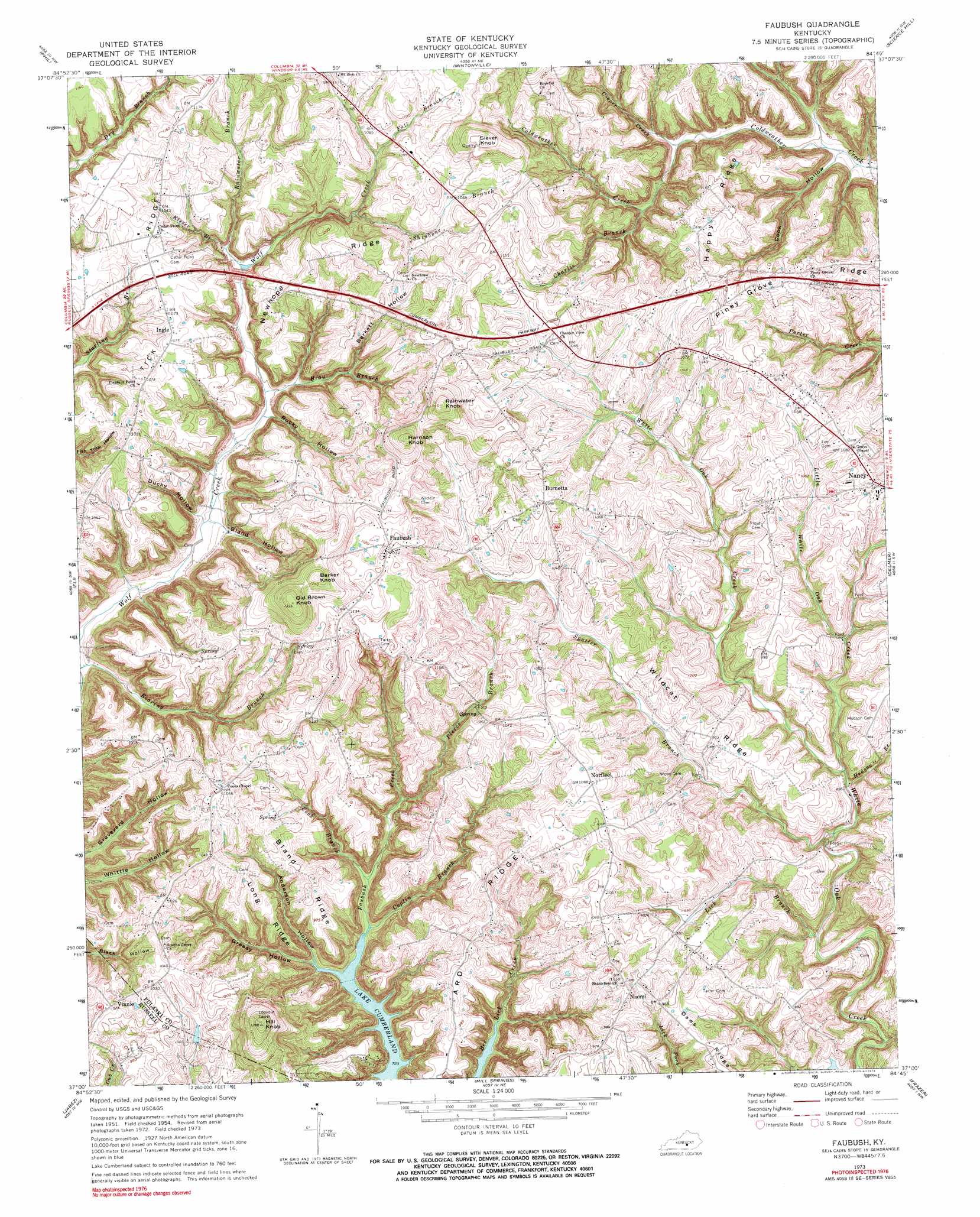
USGS Topo Quad 37084a7 - 1:24,000 scale
| Topo Map Name: | Faubush |
| USGS Topo Quad ID: | 37084a7 |
| Print Size: | ca. 21 1/4" wide x 27" high |
| Southeast Coordinates: | 37° N latitude / 84.75° W longitude |
| Map Center Coordinates: | 37.0625° N latitude / 84.8125° W longitude |
| U.S. State: | KY |
| Filename: | o37084a7.jpg |
| Download Map JPG Image: | Faubush topo map 1:24,000 scale |
| Map Type: | Topographic |
| Topo Series: | 7.5´ |
| Map Scale: | 1:24,000 |
| Source of Map Images: | United States Geological Survey (USGS) |
| Alternate Map Versions: |
Faubush KY 1954, updated 1956 Download PDF Buy paper map Faubush KY 1973, updated 1974 Download PDF Buy paper map Faubush KY 1973, updated 1976 Download PDF Buy paper map Faubush KY 2010 Download PDF Buy paper map Faubush KY 2013 Download PDF Buy paper map Faubush KY 2016 Download PDF Buy paper map |
1:24,000 Topo Quads surrounding Faubush
Clementsville |
Liberty |
Yosemite |
Eubank |
Woodstock |
Dunnville |
Phil |
Mintonville |
Science Hill |
Bobtown |
Russell Springs |
Eli |
Faubush |
Delmer |
Somerset |
Jamestown |
Jabez |
Mill Springs |
Frazer |
Burnside |
Cumberland City |
Parnell |
Monticello |
Coopersville |
Nevelsville |
> Back to 37084a1 at 1:100,000 scale
> Back to 37084a1 at 1:250,000 scale
> Back to U.S. Topo Maps home
Faubush topo map: Gazetteer
Faubush: Populated Places
Burnetta elevation 320m 1049′Faubush elevation 351m 1151′
Ingle elevation 327m 1072′
Naomi elevation 311m 1020′
Norfleet elevation 332m 1089′
Vinnie elevation 317m 1040′
Faubush: Ridges
Ard Ridge elevation 315m 1033′Bland Ridge elevation 308m 1010′
Happy Ridge elevation 363m 1190′
Long Ridge elevation 299m 980′
Newhope Ridge elevation 349m 1145′
Tick Ridge elevation 329m 1079′
Wildcat Ridge elevation 318m 1043′
Faubush: Streams
Bray Branch elevation 260m 853′Burton Branch elevation 226m 741′
Charlie Branch elevation 270m 885′
Cook Branch elevation 224m 734′
Cooper Creek elevation 262m 859′
Coplin Branch elevation 221m 725′
Fall Branch elevation 315m 1033′
Hudson Branch elevation 255m 836′
Kisser Branch elevation 284m 931′
Lick Branch elevation 242m 793′
Pierce Branch elevation 245m 803′
Rainwater Branch elevation 268m 879′
Shinbone Branch elevation 297m 974′
Sputter Branch elevation 251m 823′
White Oak Creek elevation 255m 836′
Faubush: Summits
Barker Knob elevation 393m 1289′Harrison Knob elevation 404m 1325′
Hill Knob elevation 388m 1272′
Old Brown Knob elevation 407m 1335′
Rainwater Knob elevation 408m 1338′
Siever Knob elevation 371m 1217′
Faubush: Valleys
Anderson Hollow elevation 230m 754′Berkett Hollow elevation 276m 905′
Bland Hollow elevation 253m 830′
Cook Hollow elevation 241m 790′
Ducky Hollow elevation 254m 833′
Greasy Hollow elevation 220m 721′
Rocky Hollow elevation 258m 846′
Faubush digital topo map on disk
Buy this Faubush topo map showing relief, roads, GPS coordinates and other geographical features, as a high-resolution digital map file on DVD: