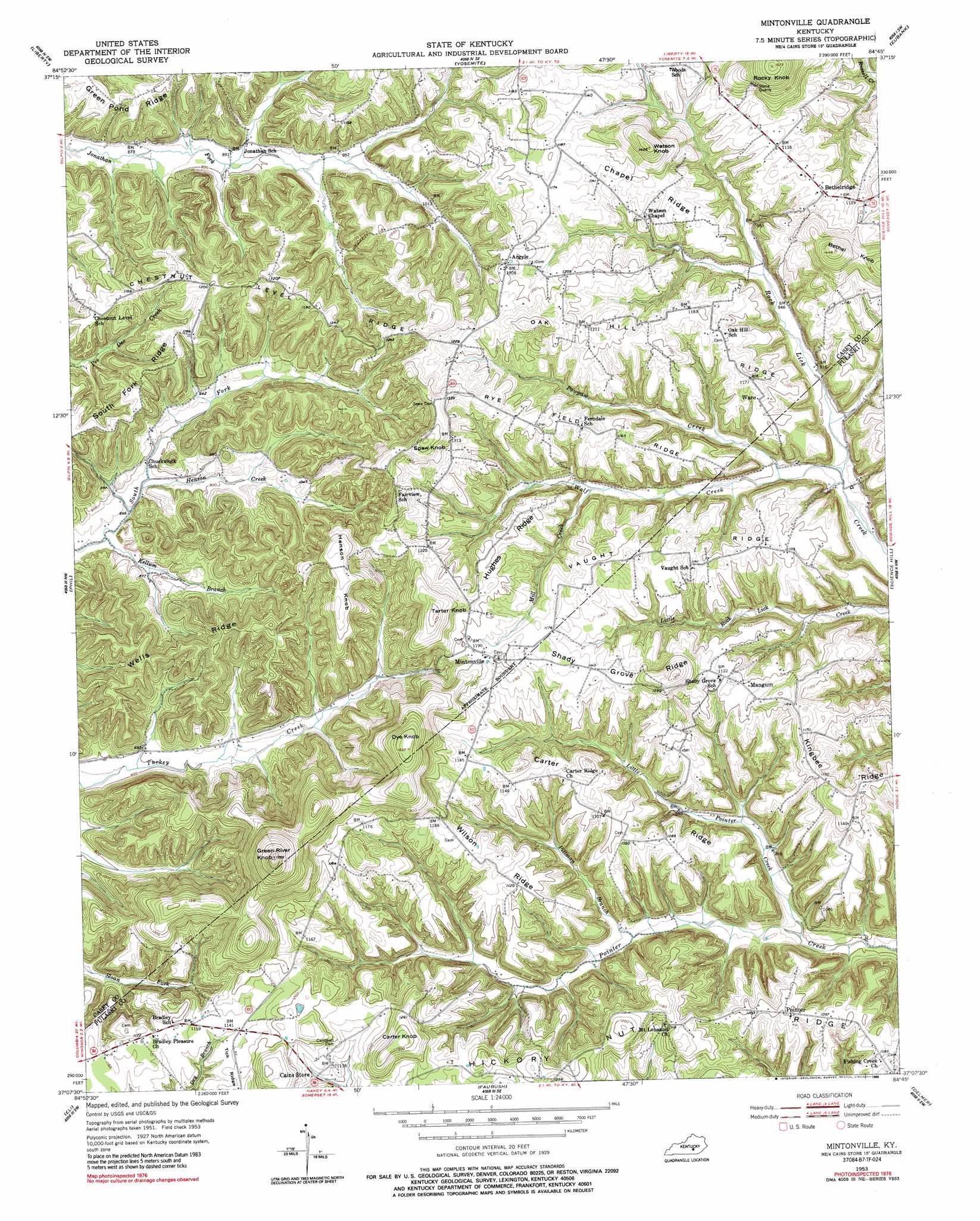
Mintonville Topo Map Kentucky
To zoom in, hover over the map of Mintonville
USGS Topo Quad 37084b7 - 1:24,000 scale
| Topo Map Name: | Mintonville |
| USGS Topo Quad ID: | 37084b7 |
| Print Size: | ca. 21 1/4" wide x 27" high |
| Southeast Coordinates: | 37.125° N latitude / 84.75° W longitude |
| Map Center Coordinates: | 37.1875° N latitude / 84.8125° W longitude |
| U.S. State: | KY |
| Filename: | o37084b7.jpg |
| Download Map JPG Image: | Mintonville topo map 1:24,000 scale |
| Map Type: | Topographic |
| Topo Series: | 7.5´ |
| Map Scale: | 1:24,000 |
| Source of Map Images: | United States Geological Survey (USGS) |
| Alternate Map Versions: |
Mintonville KY 1953, updated 1955 Download PDF Buy paper map Mintonville KY 1953, updated 1976 Download PDF Buy paper map Mintonville KY 1953, updated 1989 Download PDF Buy paper map Mintonville KY 2010 Download PDF Buy paper map Mintonville KY 2013 Download PDF Buy paper map Mintonville KY 2016 Download PDF Buy paper map |
1:24,000 Topo Quads surrounding Mintonville
Bradfordsville Ne |
Ellisburg |
Hustonville |
Halls Gap |
Crab Orchard |
Clementsville |
Liberty |
Yosemite |
Eubank |
Woodstock |
Dunnville |
Phil |
Mintonville |
Science Hill |
Bobtown |
Russell Springs |
Eli |
Faubush |
Delmer |
Somerset |
Jamestown |
Jabez |
Mill Springs |
Frazer |
Burnside |
> Back to 37084a1 at 1:100,000 scale
> Back to 37084a1 at 1:250,000 scale
> Back to U.S. Topo Maps home
Mintonville topo map: Gazetteer
Mintonville: Populated Places
Argyle elevation 369m 1210′Bethelridge elevation 347m 1138′
Ferndale (historical) elevation 361m 1184′
Mangum elevation 336m 1102′
Mintonville elevation 367m 1204′
Pointer elevation 336m 1102′
Ware elevation 345m 1131′
Mintonville: Post Offices
Argyle Post Office (historical) elevation 369m 1210′Bright Post Office (historical) elevation 294m 964′
Chuck Post Office (historical) elevation 270m 885′
Joyce Post Office (historical) elevation 334m 1095′
Mintonville Post Office (historical) elevation 362m 1187′
Ware Post Office (historical) elevation 342m 1122′
Mintonville: Ridges
Carter Ridge elevation 343m 1125′Chapel Ridge elevation 359m 1177′
Chestnut Level Ridge elevation 366m 1200′
Hickory Nut Ridge elevation 337m 1105′
Hughes Ridge elevation 365m 1197′
Oak Hill Ridge elevation 362m 1187′
Rye Field Ridge elevation 360m 1181′
Shady Grove Ridge elevation 350m 1148′
Tick Ridge elevation 352m 1154′
Vaught Ridge elevation 366m 1200′
Wells Ridge elevation 356m 1167′
Wilson Ridge elevation 356m 1167′
Mintonville: Streams
Henson Creek elevation 266m 872′Kellum Branch elevation 257m 843′
Little Pointer Creek elevation 241m 790′
Mill Creek elevation 298m 977′
Pawpaw Creek elevation 272m 892′
Pittman Branch elevation 257m 843′
Wolf Creek elevation 266m 872′
Mintonville: Summits
Bethel Knob elevation 440m 1443′Carter Knob elevation 407m 1335′
Dye Knob elevation 466m 1528′
Green River Knob elevation 531m 1742′
Henson Knob elevation 418m 1371′
Rocky Knob elevation 464m 1522′
Spaw Knob elevation 440m 1443′
Tarter Knob elevation 433m 1420′
Watson Knob elevation 429m 1407′
Mintonville digital topo map on disk
Buy this Mintonville topo map showing relief, roads, GPS coordinates and other geographical features, as a high-resolution digital map file on DVD: