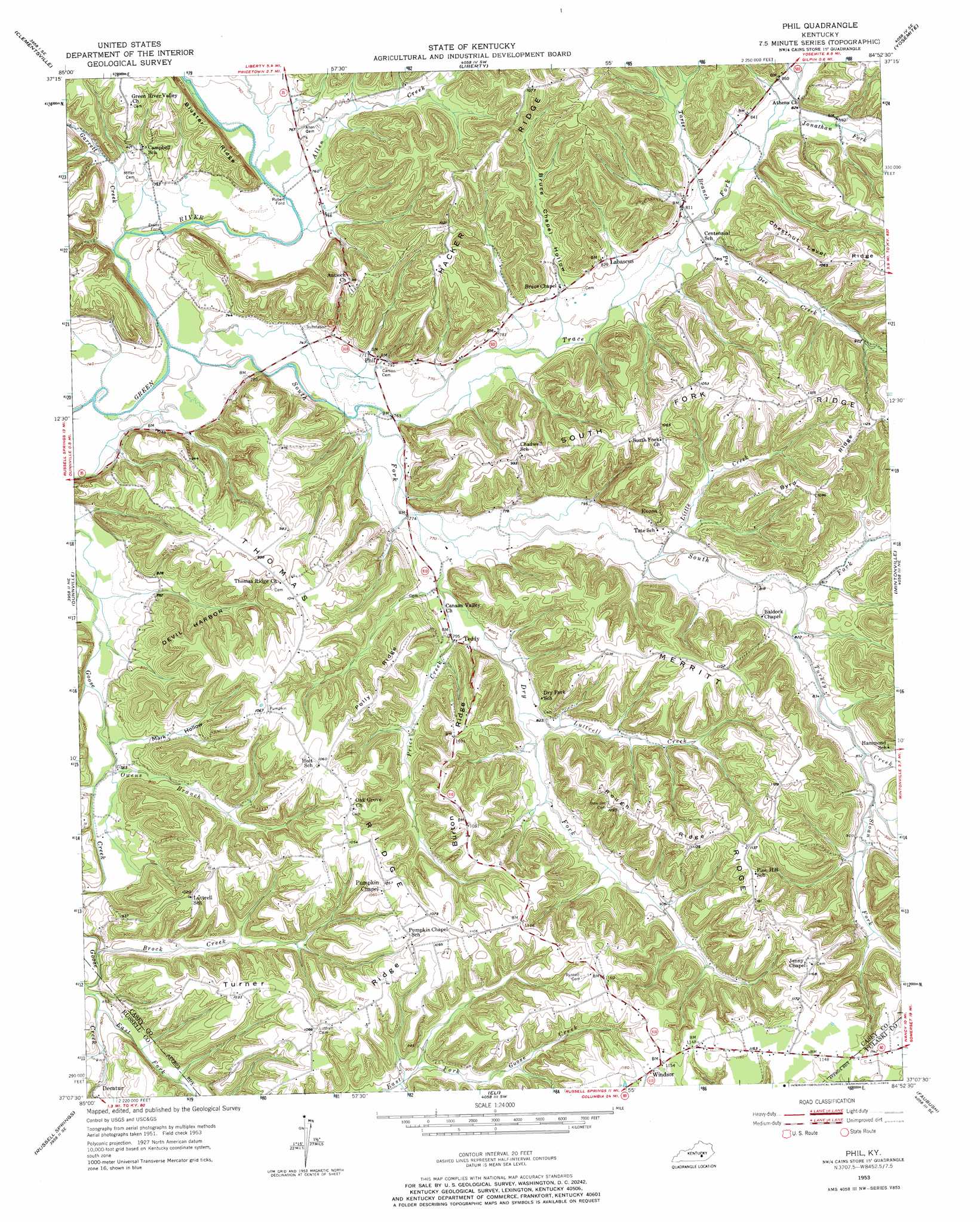
Phil Topo Map Kentucky
To zoom in, hover over the map of Phil
USGS Topo Quad 37084b8 - 1:24,000 scale
| Topo Map Name: | Phil |
| USGS Topo Quad ID: | 37084b8 |
| Print Size: | ca. 21 1/4" wide x 27" high |
| Southeast Coordinates: | 37.125° N latitude / 84.875° W longitude |
| Map Center Coordinates: | 37.1875° N latitude / 84.9375° W longitude |
| U.S. State: | KY |
| Filename: | o37084b8.jpg |
| Download Map JPG Image: | Phil topo map 1:24,000 scale |
| Map Type: | Topographic |
| Topo Series: | 7.5´ |
| Map Scale: | 1:24,000 |
| Source of Map Images: | United States Geological Survey (USGS) |
| Alternate Map Versions: |
Phil KY 1953, updated 1954 Download PDF Buy paper map Phil KY 1953, updated 1973 Download PDF Buy paper map Phil KY 2010 Download PDF Buy paper map Phil KY 2013 Download PDF Buy paper map Phil KY 2016 Download PDF Buy paper map |
1:24,000 Topo Quads surrounding Phil
Bradfordsville |
Bradfordsville Ne |
Ellisburg |
Hustonville |
Halls Gap |
Mannsville |
Clementsville |
Liberty |
Yosemite |
Eubank |
Knifley |
Dunnville |
Phil |
Mintonville |
Science Hill |
Montpelier |
Russell Springs |
Eli |
Faubush |
Delmer |
Creelsboro |
Jamestown |
Jabez |
Mill Springs |
Frazer |
> Back to 37084a1 at 1:100,000 scale
> Back to 37084a1 at 1:250,000 scale
> Back to U.S. Topo Maps home
Phil topo map: Gazetteer
Phil: Populated Places
Decatur elevation 246m 807′Evans Ford elevation 225m 738′
Evona elevation 270m 885′
Labascus elevation 258m 846′
Luttrell (historical) elevation 312m 1023′
Phil elevation 237m 777′
Rubert Ford elevation 227m 744′
Teddy elevation 248m 813′
Windsor elevation 352m 1154′
Phil: Post Offices
Allens Store Post Office (historical) elevation 229m 751′Baldock Post Office (historical) elevation 258m 846′
Coffey Post Office (historical) elevation 241m 790′
Cross Post Office (historical) elevation 251m 823′
Evana Post Office (historical) elevation 257m 843′
Labascus Post Office (historical) elevation 255m 836′
Phil Post Office (historical) elevation 242m 793′
Pumpkin Chapel Post Office (historical) elevation 325m 1066′
Teddy Post Office (historical) elevation 248m 813′
Phil: Ridges
Burton Ridge elevation 319m 1046′Byrd Ridge elevation 333m 1092′
Devil Harbor elevation 269m 882′
Hacker Ridge elevation 315m 1033′
Merritt Ridge elevation 338m 1108′
Polly Ridge elevation 314m 1030′
Rough Ridge elevation 339m 1112′
South Fork Ridge elevation 320m 1049′
Thomas Ridge elevation 324m 1062′
Turner Ridge elevation 319m 1046′
Phil: Streams
Allen Creek elevation 224m 734′Brock Creek elevation 238m 780′
Dry Fork elevation 232m 761′
East Fork Goose Creek elevation 242m 793′
Garrett Creek elevation 226m 741′
Jonathan Fork elevation 247m 810′
Little Creek elevation 243m 797′
Little Goose Creek elevation 234m 767′
Luttrell Creek elevation 247m 810′
Owens Branch elevation 232m 761′
Pee Dee Creek elevation 242m 793′
Price Creek elevation 238m 780′
Scotts Creek elevation 229m 751′
Sloan Fork elevation 258m 846′
South Fork Green River elevation 224m 734′
Tarter Branch elevation 244m 800′
Trace Fork elevation 228m 748′
Turkey Creek elevation 250m 820′
Phil: Summits
Antioch Hill elevation 295m 967′Phil: Valleys
Bruce Chapel Hollow elevation 239m 784′Mark Hollow elevation 233m 764′
Phil digital topo map on disk
Buy this Phil topo map showing relief, roads, GPS coordinates and other geographical features, as a high-resolution digital map file on DVD: