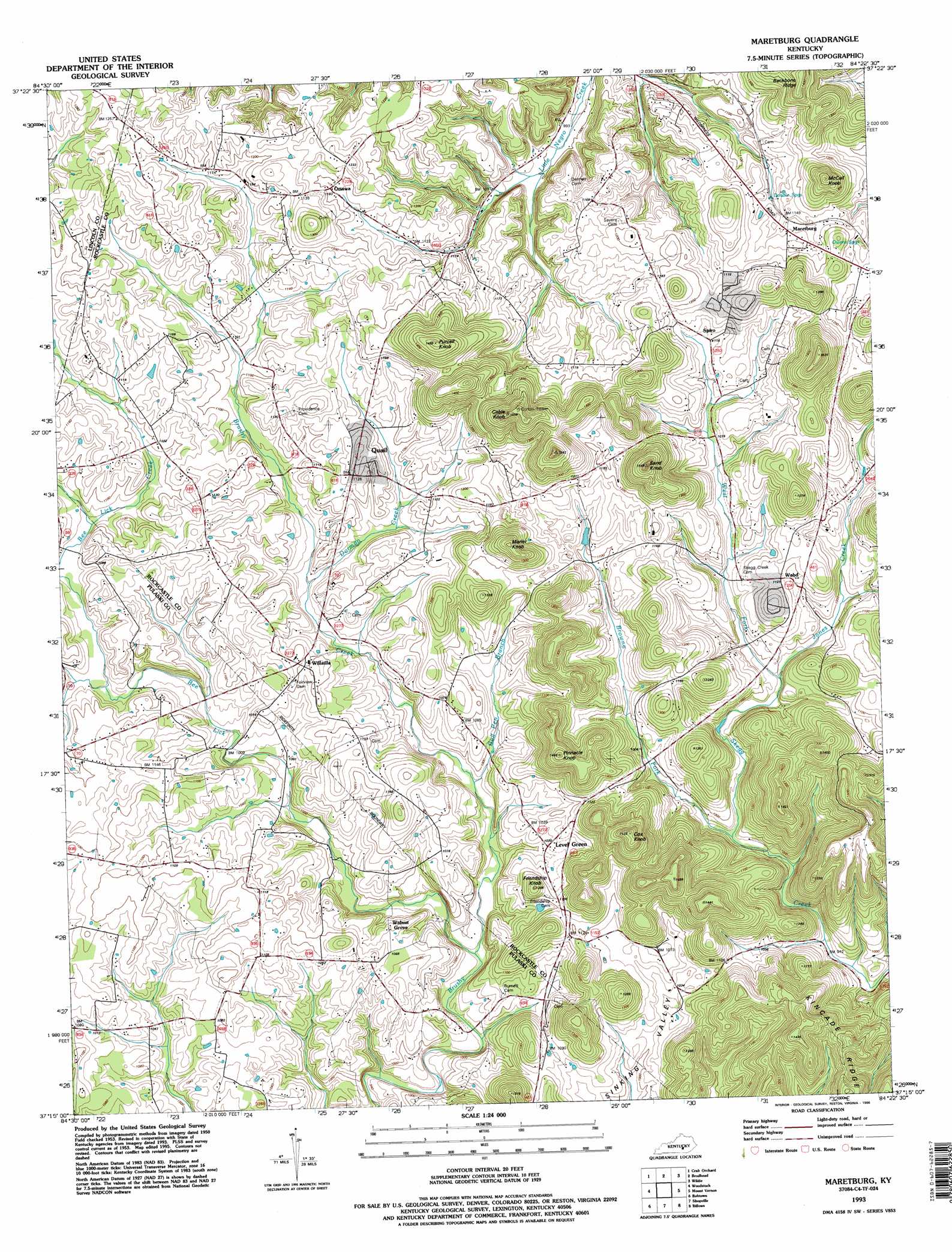
Maretburg Topo Map Kentucky
To zoom in, hover over the map of Maretburg
USGS Topo Quad 37084c4 - 1:24,000 scale
| Topo Map Name: | Maretburg |
| USGS Topo Quad ID: | 37084c4 |
| Print Size: | ca. 21 1/4" wide x 27" high |
| Southeast Coordinates: | 37.25° N latitude / 84.375° W longitude |
| Map Center Coordinates: | 37.3125° N latitude / 84.4375° W longitude |
| U.S. State: | KY |
| Filename: | o37084c4.jpg |
| Download Map JPG Image: | Maretburg topo map 1:24,000 scale |
| Map Type: | Topographic |
| Topo Series: | 7.5´ |
| Map Scale: | 1:24,000 |
| Source of Map Images: | United States Geological Survey (USGS) |
| Alternate Map Versions: |
Maretburg KY 1953, updated 1954 Download PDF Buy paper map Maretburg KY 1953, updated 1976 Download PDF Buy paper map Maretburg KY 1953, updated 1979 Download PDF Buy paper map Maretburg KY 1993, updated 1996 Download PDF Buy paper map Maretburg KY 2010 Download PDF Buy paper map Maretburg KY 2013 Download PDF Buy paper map Maretburg KY 2016 Download PDF Buy paper map |
1:24,000 Topo Quads surrounding Maretburg
Stanford |
Lancaster |
Paint Lick |
Berea |
Bighill |
Halls Gap |
Crab Orchard |
Brodhead |
Wildie |
Johnetta |
Eubank |
Woodstock |
Maretburg |
Mount Vernon |
Livingston |
Science Hill |
Bobtown |
Shopville |
Billows |
Bernstadt |
Delmer |
Somerset |
Dykes |
Ano |
London Sw |
> Back to 37084a1 at 1:100,000 scale
> Back to 37084a1 at 1:250,000 scale
> Back to U.S. Topo Maps home
Maretburg topo map: Gazetteer
Maretburg: Airports
Rock Spring Airport elevation 322m 1056′Maretburg: Populated Places
Level Green elevation 318m 1043′Maretburg elevation 354m 1161′
Ottawa elevation 360m 1181′
Quail elevation 345m 1131′
Spiro elevation 341m 1118′
Wabd elevation 342m 1122′
Walnut Grove elevation 323m 1059′
Willailla elevation 335m 1099′
Maretburg: Ridges
Backbone Ridge elevation 440m 1443′Kincade Ridge elevation 397m 1302′
Maretburg: Springs
Double Springs elevation 340m 1115′Owens Spring elevation 347m 1138′
Maretburg: Streams
Bee Lick Creek elevation 285m 935′Bee Lick Creek elevation 285m 935′
Browne Fork elevation 289m 948′
Bull Pen Branch elevation 294m 964′
Dorman Creek elevation 312m 1023′
Jones Creek elevation 296m 971′
Warren Branch elevation 317m 1040′
Maretburg: Summits
Cable Knob elevation 465m 1525′Cox Knob elevation 449m 1473′
Friendship Knob elevation 363m 1190′
Marler Knob elevation 417m 1368′
McCall Knob elevation 437m 1433′
Pinnacle Knob elevation 438m 1437′
Purcell Knob elevation 453m 1486′
Sand Knob elevation 462m 1515′
Maretburg digital topo map on disk
Buy this Maretburg topo map showing relief, roads, GPS coordinates and other geographical features, as a high-resolution digital map file on DVD: