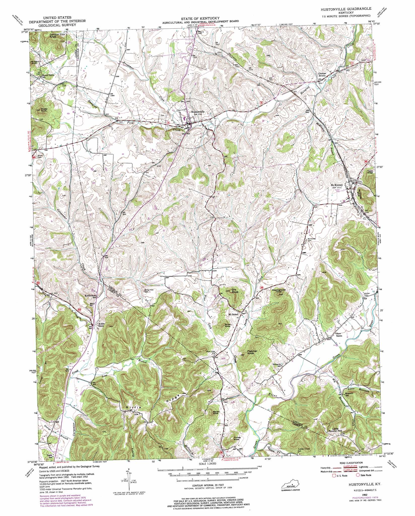
Hustonville Topo Map Kentucky
To zoom in, hover over the map of Hustonville
USGS Topo Quad 37084d7 - 1:24,000 scale
| Topo Map Name: | Hustonville |
| USGS Topo Quad ID: | 37084d7 |
| Print Size: | ca. 21 1/4" wide x 27" high |
| Southeast Coordinates: | 37.375° N latitude / 84.75° W longitude |
| Map Center Coordinates: | 37.4375° N latitude / 84.8125° W longitude |
| U.S. State: | KY |
| Filename: | o37084d7.jpg |
| Download Map JPG Image: | Hustonville topo map 1:24,000 scale |
| Map Type: | Topographic |
| Topo Series: | 7.5´ |
| Map Scale: | 1:24,000 |
| Source of Map Images: | United States Geological Survey (USGS) |
| Alternate Map Versions: |
Hustonville KY 1952, updated 1953 Download PDF Buy paper map Hustonville KY 1952, updated 1969 Download PDF Buy paper map Hustonville KY 1952, updated 1979 Download PDF Buy paper map Hustonville KY 2010 Download PDF Buy paper map Hustonville KY 2013 Download PDF Buy paper map Hustonville KY 2016 Download PDF Buy paper map |
1:24,000 Topo Quads surrounding Hustonville
Mackville |
Perryville |
Danville |
Bryantsville |
Buckeye |
Gravel Switch |
Parksville |
Junction City |
Stanford |
Lancaster |
Bradfordsville Ne |
Ellisburg |
Hustonville |
Halls Gap |
Crab Orchard |
Clementsville |
Liberty |
Yosemite |
Eubank |
Woodstock |
Dunnville |
Phil |
Mintonville |
Science Hill |
Bobtown |
> Back to 37084a1 at 1:100,000 scale
> Back to 37084a1 at 1:250,000 scale
> Back to U.S. Topo Maps home
Hustonville topo map: Gazetteer
Hustonville: Cliffs
McKinney Bluff elevation 383m 1256′Hustonville: Populated Places
Carpenter Creek (historical) elevation 292m 958′Chicken Bristle elevation 286m 938′
Hustonville elevation 300m 984′
McKinney elevation 311m 1020′
Mount Salem elevation 288m 944′
New Salem elevation 273m 895′
Ruletown (historical) elevation 336m 1102′
Stapp (historical) elevation 267m 875′
Hustonville: Post Offices
Kidds Store Post Office (historical) elevation 284m 931′Hustonville: Ridges
Riffle Ridge elevation 338m 1108′Yates Ridge elevation 368m 1207′
Hustonville: Streams
Baughman Creek elevation 296m 971′Big Moccasin Creek elevation 262m 859′
Cow Creek elevation 289m 948′
Frey Creek elevation 267m 875′
George Branch elevation 256m 839′
Indian Creek elevation 259m 849′
Little Moccasin Creek elevation 276m 905′
Long Branch elevation 261m 856′
McKinney Branch elevation 280m 918′
Peltis Fork elevation 270m 885′
Pettis Fork elevation 270m 885′
Pigeon Creek elevation 302m 990′
Pine Lick Creek elevation 261m 856′
South Fork Green River elevation 273m 895′
Spears Creek elevation 299m 980′
Hustonville: Summits
Buzzard Knob elevation 371m 1217′Dry Knob elevation 386m 1266′
Fletcher Knob elevation 363m 1190′
Gordon Lick Knob elevation 412m 1351′
Grider Knob elevation 341m 1118′
Little Round Hill elevation 349m 1145′
Martin Knob elevation 359m 1177′
Maxey Knob elevation 408m 1338′
Meetinghouse Knob elevation 372m 1220′
Turkey Knob elevation 339m 1112′
Hustonville digital topo map on disk
Buy this Hustonville topo map showing relief, roads, GPS coordinates and other geographical features, as a high-resolution digital map file on DVD: