Berea Topo Map Kentucky
To zoom in, hover over the map of Berea
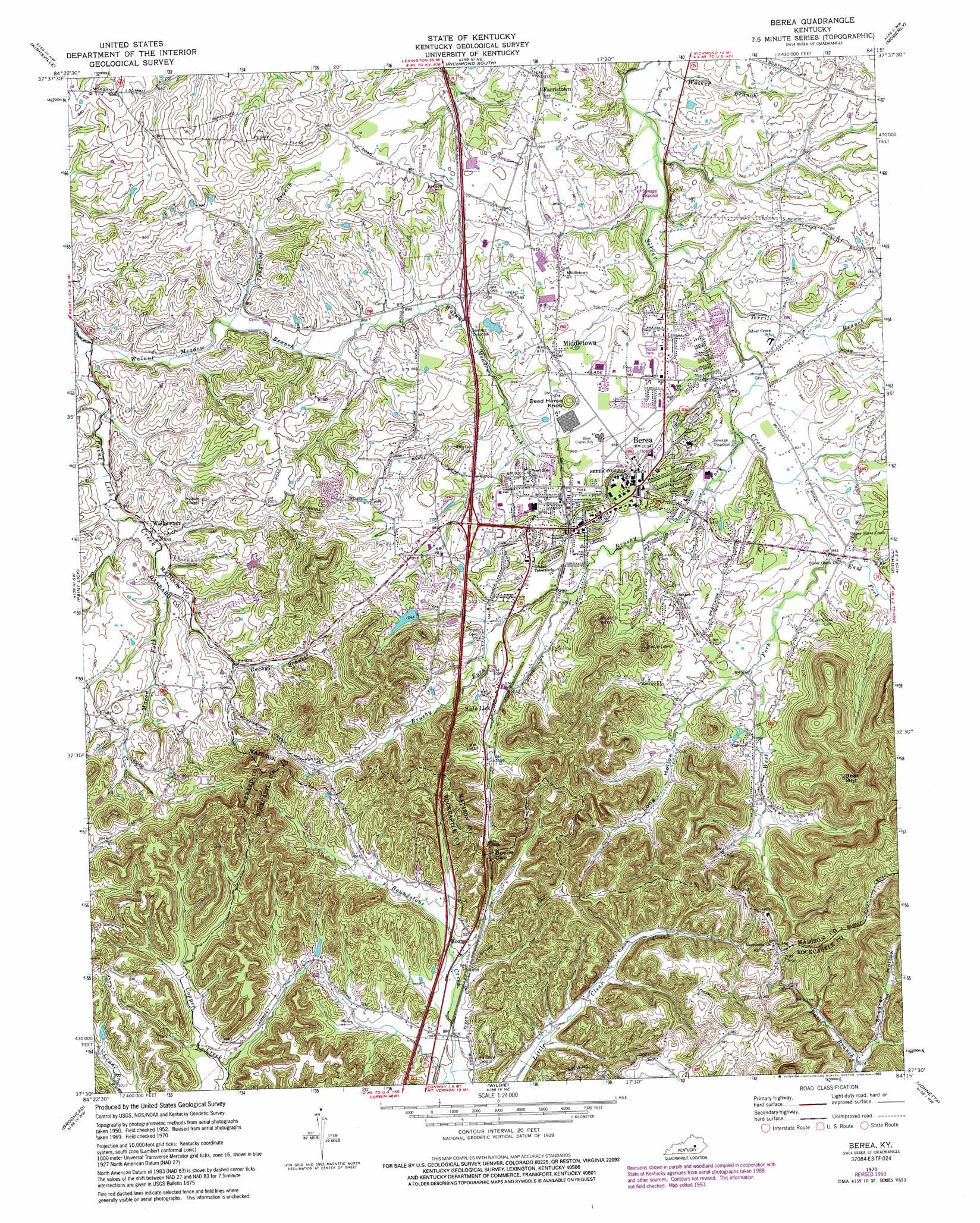
USGS Topo Quad 37084e3 - 1:24,000 scale
| Topo Map Name: | Berea |
| USGS Topo Quad ID: | 37084e3 |
| Print Size: | ca. 21 1/4" wide x 27" high |
| Southeast Coordinates: | 37.5° N latitude / 84.25° W longitude |
| Map Center Coordinates: | 37.5625° N latitude / 84.3125° W longitude |
| U.S. State: | KY |
| Filename: | o37084e3.jpg |
| Download Map JPG Image: | Berea topo map 1:24,000 scale |
| Map Type: | Topographic |
| Topo Series: | 7.5´ |
| Map Scale: | 1:24,000 |
| Source of Map Images: | United States Geological Survey (USGS) |
| Alternate Map Versions: |
Berea KY 1952, updated 1953 Download PDF Buy paper map Berea KY 1970, updated 1972 Download PDF Buy paper map Berea KY 1970, updated 1979 Download PDF Buy paper map Berea KY 1970, updated 1984 Download PDF Buy paper map Berea KY 1970, updated 1993 Download PDF Buy paper map Berea KY 1970, updated 1993 Download PDF Buy paper map Berea KY 2010 Download PDF Buy paper map Berea KY 2013 Download PDF Buy paper map Berea KY 2016 Download PDF Buy paper map |
1:24,000 Topo Quads surrounding Berea
Little Hickman |
Valley View |
Richmond North |
Union City |
Palmer |
Buckeye |
Kirksville |
Richmond South |
Moberly |
Panola |
Lancaster |
Paint Lick |
Berea |
Bighill |
Alcorn |
Crab Orchard |
Brodhead |
Wildie |
Johnetta |
Sandgap |
Woodstock |
Maretburg |
Mount Vernon |
Livingston |
Parrot |
> Back to 37084e1 at 1:100,000 scale
> Back to 37084a1 at 1:250,000 scale
> Back to U.S. Topo Maps home
Berea topo map: Gazetteer
Berea: Areas
The Glades elevation 281m 921′Berea: Gaps
Boone Gap elevation 360m 1181′Berea: Populated Places
Berea elevation 312m 1023′Blythewood Estates (historical) elevation 298m 977′
Boone elevation 316m 1036′
Farristown elevation 297m 974′
Middletown elevation 297m 974′
Slate Lick elevation 304m 997′
Wallaceton elevation 270m 885′
Berea: Post Offices
Asbury Post Office (historical) elevation 322m 1056′Johnsons Shop Post Office (historical) elevation 280m 918′
Wallaceton Post Office (historical) elevation 271m 889′
Berea: Ridges
Scaffold Cane Ridge elevation 411m 1348′Berea: Streams
Brushy Fork elevation 279m 915′East Fork Silver Creek elevation 286m 938′
Judytown Branch elevation 263m 862′
Mason Fork elevation 272m 892′
Rocky Branch elevation 272m 892′
Terrill Branch elevation 274m 898′
Walnut Meadow Branch elevation 256m 839′
West Fork Silver Creek elevation 286m 938′
Wolf Branch elevation 322m 1056′
Berea: Summits
Bear Mountain elevation 505m 1656′Dead Horse Knob elevation 312m 1023′
Welch Mountain elevation 384m 1259′
Berea: Valleys
Bear Mountain Hollow elevation 308m 1010′Davis Hollow elevation 291m 954′
Long Hollow elevation 297m 974′
Shearer Hollow elevation 331m 1085′
Berea digital topo map on disk
Buy this Berea topo map showing relief, roads, GPS coordinates and other geographical features, as a high-resolution digital map file on DVD: