Lancaster Topo Map Kentucky
To zoom in, hover over the map of Lancaster
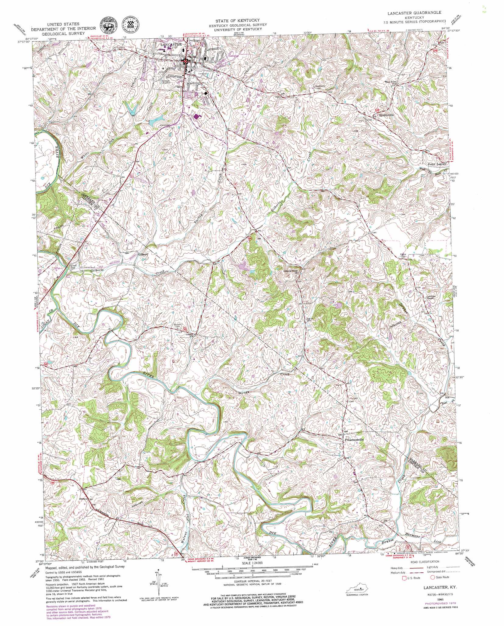
USGS Topo Quad 37084e5 - 1:24,000 scale
| Topo Map Name: | Lancaster |
| USGS Topo Quad ID: | 37084e5 |
| Print Size: | ca. 21 1/4" wide x 27" high |
| Southeast Coordinates: | 37.5° N latitude / 84.5° W longitude |
| Map Center Coordinates: | 37.5625° N latitude / 84.5625° W longitude |
| U.S. State: | KY |
| Filename: | o37084e5.jpg |
| Download Map JPG Image: | Lancaster topo map 1:24,000 scale |
| Map Type: | Topographic |
| Topo Series: | 7.5´ |
| Map Scale: | 1:24,000 |
| Source of Map Images: | United States Geological Survey (USGS) |
| Alternate Map Versions: |
Lancaster KY 1952, updated 1953 Download PDF Buy paper map Lancaster KY 1961, updated 1962 Download PDF Buy paper map Lancaster KY 1961, updated 1979 Download PDF Buy paper map Lancaster KY 2010 Download PDF Buy paper map Lancaster KY 2013 Download PDF Buy paper map Lancaster KY 2016 Download PDF Buy paper map |
1:24,000 Topo Quads surrounding Lancaster
Harrodsburg |
Wilmore |
Little Hickman |
Valley View |
Richmond North |
Danville |
Bryantsville |
Buckeye |
Kirksville |
Richmond South |
Junction City |
Stanford |
Lancaster |
Paint Lick |
Berea |
Hustonville |
Halls Gap |
Crab Orchard |
Brodhead |
Wildie |
Yosemite |
Eubank |
Woodstock |
Maretburg |
Mount Vernon |
> Back to 37084e1 at 1:100,000 scale
> Back to 37084a1 at 1:250,000 scale
> Back to U.S. Topo Maps home
Lancaster topo map: Gazetteer
Lancaster: Populated Places
Gilbert elevation 260m 853′Hyattsville elevation 317m 1040′
Lancaster elevation 313m 1026′
Mount Zenia (historical) elevation 251m 823′
Preachersville elevation 301m 987′
Lancaster: Post Offices
Gilberts Creek Post Office (historical) elevation 261m 856′Hyattsville Post Office (historical) elevation 316m 1036′
Point Leavell Post Office (historical) elevation 283m 928′
Preachersville Post Office (historical) elevation 301m 987′
Sweeney Post Office (historical) elevation 319m 1046′
Lancaster: Streams
Cedar Creek elevation 257m 843′Drakes Creek elevation 256m 839′
East Fork Drakes Creek elevation 275m 902′
Gilberts Creek elevation 248m 813′
Harmons Lick elevation 262m 859′
Logan Creek elevation 251m 823′
Stingy Creek elevation 249m 816′
Turkey Creek elevation 257m 843′
Walnut Flat Creek elevation 251m 823′
White Oak Creek elevation 243m 797′
Lancaster: Summits
Mount Zenia elevation 282m 925′Lancaster digital topo map on disk
Buy this Lancaster topo map showing relief, roads, GPS coordinates and other geographical features, as a high-resolution digital map file on DVD: