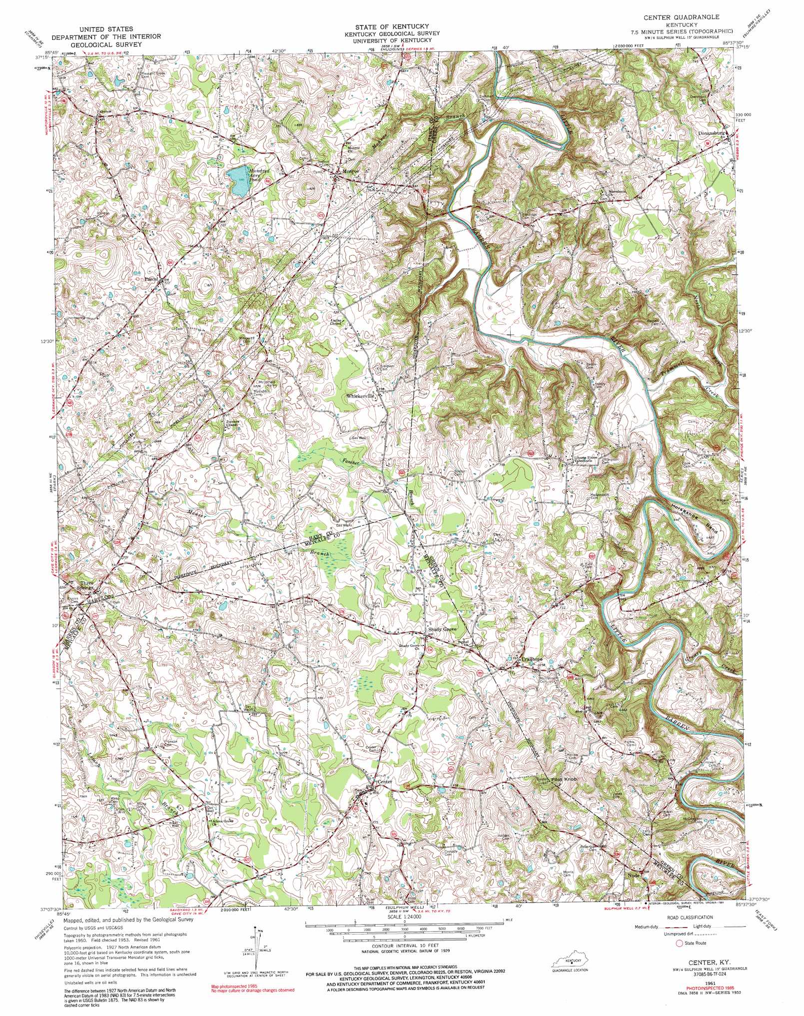
Center Topo Map Kentucky
To zoom in, hover over the map of Center
USGS Topo Quad 37085b6 - 1:24,000 scale
| Topo Map Name: | Center |
| USGS Topo Quad ID: | 37085b6 |
| Print Size: | ca. 21 1/4" wide x 27" high |
| Southeast Coordinates: | 37.125° N latitude / 85.625° W longitude |
| Map Center Coordinates: | 37.1875° N latitude / 85.6875° W longitude |
| U.S. State: | KY |
| Filename: | o37085b6.jpg |
| Download Map JPG Image: | Center topo map 1:24,000 scale |
| Map Type: | Topographic |
| Topo Series: | 7.5´ |
| Map Scale: | 1:24,000 |
| Source of Map Images: | United States Geological Survey (USGS) |
| Alternate Map Versions: |
Center KY 1953, updated 1955 Download PDF Buy paper map Center KY 1961, updated 1963 Download PDF Buy paper map Center KY 1961, updated 1973 Download PDF Buy paper map Center KY 1961, updated 1976 Download PDF Buy paper map Center KY 1961, updated 1991 Download PDF Buy paper map Center KY 2010 Download PDF Buy paper map Center KY 2013 Download PDF Buy paper map Center KY 2016 Download PDF Buy paper map |
1:24,000 Topo Quads surrounding Center
Upton |
Hammonville |
Magnolia |
Hibernia |
Saloma |
Munfordville |
Canmer |
Hudgins |
Summersville |
Greensburg |
Horse Cave |
Park |
Center |
Exie |
Gresham |
Glasgow North |
Hiseville |
Sulphur Well |
East Fork |
Gradyville |
Glasgow South |
Temple Hill |
Summer Shade |
Edmonton |
Breeding |
> Back to 37085a1 at 1:100,000 scale
> Back to 37084a1 at 1:250,000 scale
> Back to U.S. Topo Maps home
Center topo map: Gazetteer
Center: Bends
Horseshoe Bend elevation 170m 557′Center: Lakes
Hundred Acre Pond elevation 208m 682′Center: Populated Places
Center elevation 245m 803′Crailhope elevation 238m 780′
Donansburg elevation 230m 754′
Monroe elevation 217m 711′
Node elevation 229m 751′
Pascal elevation 219m 718′
Shady Grove elevation 238m 780′
Three Springs elevation 210m 688′
Whickerville elevation 224m 734′
Center: Streams
East Fork Little Barren River elevation 173m 567′Fancher Branch elevation 215m 705′
Greasy Creek elevation 164m 538′
Monroe Branch elevation 155m 508′
Mouser Branch elevation 198m 649′
North Fork Trammell Creek elevation 162m 531′
South Fork Little Barren River elevation 173m 567′
Trammell Creek elevation 155m 508′
Center: Summits
Pilot Knob elevation 312m 1023′Center digital topo map on disk
Buy this Center topo map showing relief, roads, GPS coordinates and other geographical features, as a high-resolution digital map file on DVD: