Bradfordsville Ne Topo Map Kentucky
To zoom in, hover over the map of Bradfordsville Ne
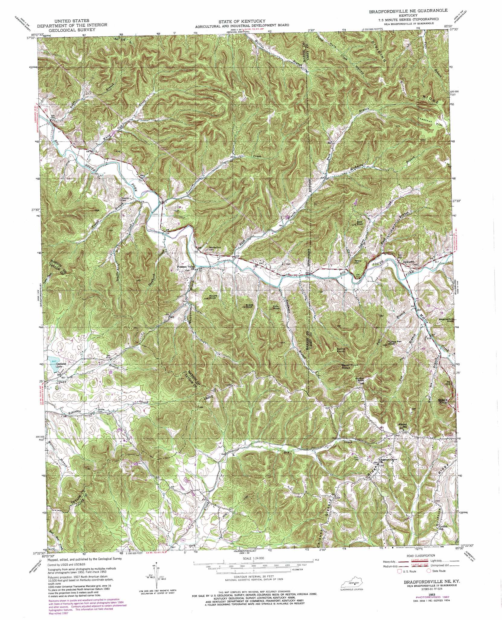
USGS Topo Quad 37085d1 - 1:24,000 scale
| Topo Map Name: | Bradfordsville Ne |
| USGS Topo Quad ID: | 37085d1 |
| Print Size: | ca. 21 1/4" wide x 27" high |
| Southeast Coordinates: | 37.375° N latitude / 85° W longitude |
| Map Center Coordinates: | 37.4375° N latitude / 85.0625° W longitude |
| U.S. State: | KY |
| Filename: | o37085d1.jpg |
| Download Map JPG Image: | Bradfordsville Ne topo map 1:24,000 scale |
| Map Type: | Topographic |
| Topo Series: | 7.5´ |
| Map Scale: | 1:24,000 |
| Source of Map Images: | United States Geological Survey (USGS) |
| Alternate Map Versions: |
Bradfordsville NE KY 1953, updated 1954 Download PDF Buy paper map Bradfordsville NE KY 1953, updated 1988 Download PDF Buy paper map Bradfordsville NE KY 2010 Download PDF Buy paper map Bradfordsville NE KY 2013 Download PDF Buy paper map Bradfordsville NE KY 2016 Download PDF Buy paper map |
1:24,000 Topo Quads surrounding Bradfordsville Ne
Saint Catherine |
Springfield |
Mackville |
Perryville |
Danville |
Lebanon West |
Lebanon East |
Gravel Switch |
Parksville |
Junction City |
Spurlington |
Bradfordsville |
Bradfordsville Ne |
Ellisburg |
Hustonville |
Campbellsville |
Mannsville |
Clementsville |
Liberty |
Yosemite |
Cane Valley |
Knifley |
Dunnville |
Phil |
Mintonville |
> Back to 37085a1 at 1:100,000 scale
> Back to 37084a1 at 1:250,000 scale
> Back to U.S. Topo Maps home
Bradfordsville Ne topo map: Gazetteer
Bradfordsville Ne: Falls
Stacy Falls elevation 299m 980′Bradfordsville Ne: Flats
Chestnut Flat elevation 400m 1312′Bradfordsville Ne: Populated Places
Jacktown elevation 250m 820′Rush Branch (historical) elevation 230m 754′
Whippoorwill (historical) elevation 245m 803′
Bradfordsville Ne: Post Offices
Peck Post Office (historical) elevation 283m 928′Rush Branch Post Office (historical) elevation 227m 744′
Wess Post Office (historical) elevation 377m 1236′
Bradfordsville Ne: Reservoirs
Oakland Lake elevation 257m 843′Bradfordsville Ne: Ridges
Griffith Ridge elevation 371m 1217′Hazel Point elevation 362m 1187′
Bradfordsville Ne: Streams
Buck Branch elevation 237m 777′Cox Branch elevation 248m 813′
Fort Branch elevation 243m 797′
Indian Creek elevation 236m 774′
Martin Creek elevation 238m 780′
McAnelly Branch elevation 250m 820′
Needmore Branch elevation 230m 754′
Rakes Branch elevation 207m 679′
Rush Branch elevation 227m 744′
Scuffle Creek elevation 216m 708′
Shepherd Creek elevation 221m 725′
Traverse Creek elevation 219m 718′
Whippoorwill Branch elevation 225m 738′
White Oak Creek elevation 213m 698′
Wolf Pen Branch elevation 253m 830′
Yowell Branch elevation 216m 708′
Bradfordsville Ne: Summits
Bald Knob elevation 305m 1000′Button Knob elevation 396m 1299′
Ellis Knob elevation 296m 971′
Evans Knob elevation 301m 987′
Round Knob elevation 299m 980′
Seths Knob elevation 378m 1240′
Steele Knob elevation 369m 1210′
Turkey Pen Knob elevation 361m 1184′
Bradfordsville Ne digital topo map on disk
Buy this Bradfordsville Ne topo map showing relief, roads, GPS coordinates and other geographical features, as a high-resolution digital map file on DVD: