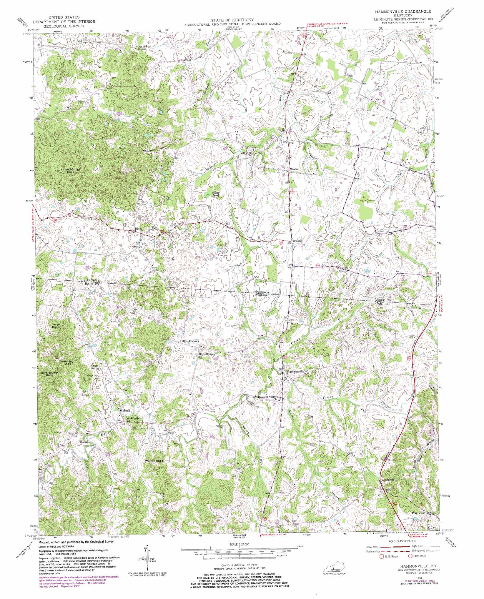
Hammonville Topo Map Kentucky
To zoom in, hover over the map of Hammonville
USGS Topo Quad 37085d7 - 1:24,000 scale
| Topo Map Name: | Hammonville |
| USGS Topo Quad ID: | 37085d7 |
| Print Size: | ca. 21 1/4" wide x 27" high |
| Southeast Coordinates: | 37.375° N latitude / 85.75° W longitude |
| Map Center Coordinates: | 37.4375° N latitude / 85.8125° W longitude |
| U.S. State: | KY |
| Filename: | o37085d7.jpg |
| Download Map JPG Image: | Hammonville topo map 1:24,000 scale |
| Map Type: | Topographic |
| Topo Series: | 7.5´ |
| Map Scale: | 1:24,000 |
| Source of Map Images: | United States Geological Survey (USGS) |
| Alternate Map Versions: |
Hammonville KY 1954, updated 1955 Download PDF Buy paper map Hammonville KY 1954, updated 1968 Download PDF Buy paper map Hammonville KY 1954, updated 1982 Download PDF Buy paper map Hammonville KY 2010 Download PDF Buy paper map Hammonville KY 2013 Download PDF Buy paper map Hammonville KY 2016 Download PDF Buy paper map |
1:24,000 Topo Quads surrounding Hammonville
Howe Valley |
Cecilia |
Elizabethtown |
Nelsonville |
New Haven |
Summit |
Sonora |
Tonieville |
Hodgenville |
Howardstown |
Millerstown |
Upton |
Hammonville |
Magnolia |
Hibernia |
Cub Run |
Munfordville |
Canmer |
Hudgins |
Summersville |
Mammoth Cave |
Horse Cave |
Park |
Center |
Exie |
> Back to 37085a1 at 1:100,000 scale
> Back to 37084a1 at 1:250,000 scale
> Back to U.S. Topo Maps home
Hammonville topo map: Gazetteer
Hammonville: Lakes
Clear Pond elevation 240m 787′Hammonville: Populated Places
Hammonville elevation 217m 711′High Hickory elevation 237m 777′
In The Bark of Wonderland (historical) elevation 263m 862′
Jonesville elevation 263m 862′
Keith (historical) elevation 235m 770′
Maxine elevation 253m 830′
Pike View elevation 252m 826′
Talley elevation 240m 787′
Wabash elevation 206m 675′
Hammonville: Post Offices
Maxine Post Office (historical) elevation 252m 826′Oak Hill Post Office (historical) elevation 246m 807′
Parkers Grove Post Office (historical) elevation 260m 853′
Hammonville: Springs
Cave Spring elevation 215m 705′Hammonville: Streams
Honey Run elevation 212m 695′Martis Branch elevation 214m 702′
Tampa Branch elevation 213m 698′
Tucker Creek elevation 231m 757′
Hammonville: Summits
Gore Stump Knob elevation 252m 826′Kennedy Knob elevation 261m 856′
Three Springs Knob elevation 291m 954′
Veach Knob elevation 271m 889′
Warren Knob elevation 268m 879′
Hammonville: Valleys
Barefoot Hollow elevation 247m 810′Hammonville digital topo map on disk
Buy this Hammonville topo map showing relief, roads, GPS coordinates and other geographical features, as a high-resolution digital map file on DVD: