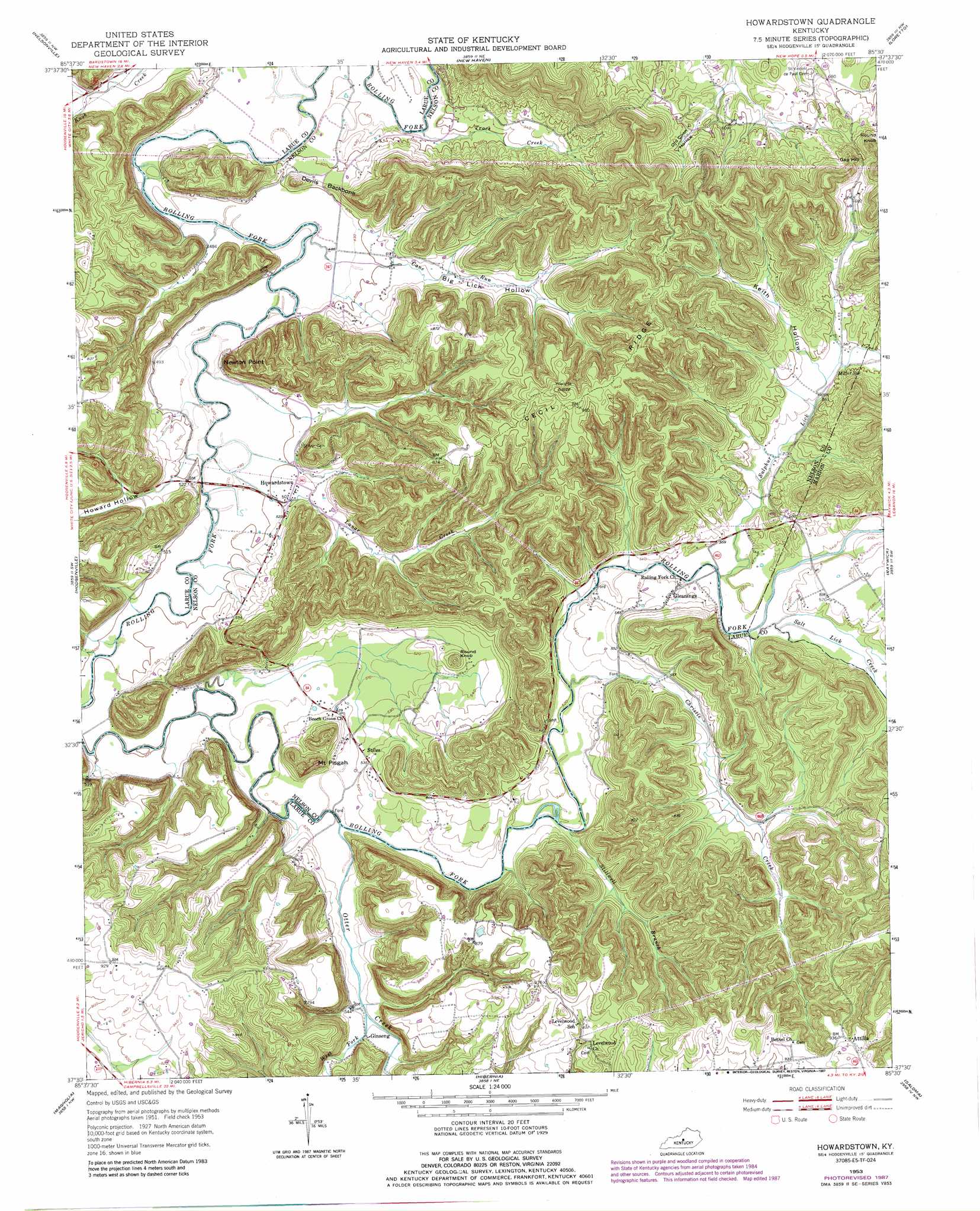
Howardstown Topo Map Kentucky
To zoom in, hover over the map of Howardstown
USGS Topo Quad 37085e5 - 1:24,000 scale
| Topo Map Name: | Howardstown |
| USGS Topo Quad ID: | 37085e5 |
| Print Size: | ca. 21 1/4" wide x 27" high |
| Southeast Coordinates: | 37.5° N latitude / 85.5° W longitude |
| Map Center Coordinates: | 37.5625° N latitude / 85.5625° W longitude |
| U.S. State: | KY |
| Filename: | o37085e5.jpg |
| Download Map JPG Image: | Howardstown topo map 1:24,000 scale |
| Map Type: | Topographic |
| Topo Series: | 7.5´ |
| Map Scale: | 1:24,000 |
| Source of Map Images: | United States Geological Survey (USGS) |
| Alternate Map Versions: |
Howardstown KY 1953, updated 1954 Download PDF Buy paper map Howardstown KY 1953, updated 1968 Download PDF Buy paper map Howardstown KY 1953, updated 1984 Download PDF Buy paper map Howardstown KY 1953, updated 1987 Download PDF Buy paper map Howardstown KY 2010 Download PDF Buy paper map Howardstown KY 2013 Download PDF Buy paper map Howardstown KY 2016 Download PDF Buy paper map |
1:24,000 Topo Quads surrounding Howardstown
Colesburg |
Lebanon Junction |
Cravens |
Bardstown |
Maud |
Elizabethtown |
Nelsonville |
New Haven |
Loretto |
Saint Catherine |
Tonieville |
Hodgenville |
Howardstown |
Raywick |
Lebanon West |
Hammonville |
Magnolia |
Hibernia |
Saloma |
Spurlington |
Canmer |
Hudgins |
Summersville |
Greensburg |
Campbellsville |
> Back to 37085e1 at 1:100,000 scale
> Back to 37084a1 at 1:250,000 scale
> Back to U.S. Topo Maps home
Howardstown topo map: Gazetteer
Howardstown: Capes
Newton Point elevation 179m 587′Howardstown: Crossings
Brays Ford (historical) elevation 158m 518′McGee and Boone Ford elevation 143m 469′
Old Ford (historical) elevation 140m 459′
Howardstown: Populated Places
Attilla elevation 288m 944′Ginseng elevation 169m 554′
Gleanings elevation 173m 567′
Howardstown elevation 155m 508′
Stiles elevation 163m 534′
Howardstown: Post Offices
Attilla Post Office (historical) elevation 283m 928′Ginseng Post Office (historical) elevation 167m 547′
Gleanings Post Office (historical) elevation 171m 561′
Mobley Post Office (historical) elevation 168m 551′
Salt Lick Post Office (historical) elevation 161m 528′
Howardstown: Ridges
Cecil Ridge elevation 288m 944′Devils Backbone elevation 160m 524′
Howardstown: Springs
Miller Spring elevation 176m 577′Howardstown: Streams
Cane Run elevation 146m 479′Christie Creek elevation 158m 518′
Lunar Creek elevation 147m 482′
Otter Creek elevation 153m 501′
Salt Lick Creek elevation 159m 521′
Stillwell Branch elevation 156m 511′
Sulphur Lick Creek elevation 158m 518′
Thompson Creek elevation 147m 482′
Trace Creek elevation 141m 462′
West Fork Otter Creek elevation 163m 534′
Howardstown: Summits
Gap Hill elevation 252m 826′Mount Pisgah elevation 219m 718′
Round Knob elevation 210m 688′
Round Knob elevation 280m 918′
Howardstown: Valleys
Big Lick Hollow elevation 156m 511′Howard Hollow elevation 155m 508′
Keith Hollow elevation 176m 577′
Old Coon Hollow elevation 176m 577′
Howardstown digital topo map on disk
Buy this Howardstown topo map showing relief, roads, GPS coordinates and other geographical features, as a high-resolution digital map file on DVD: