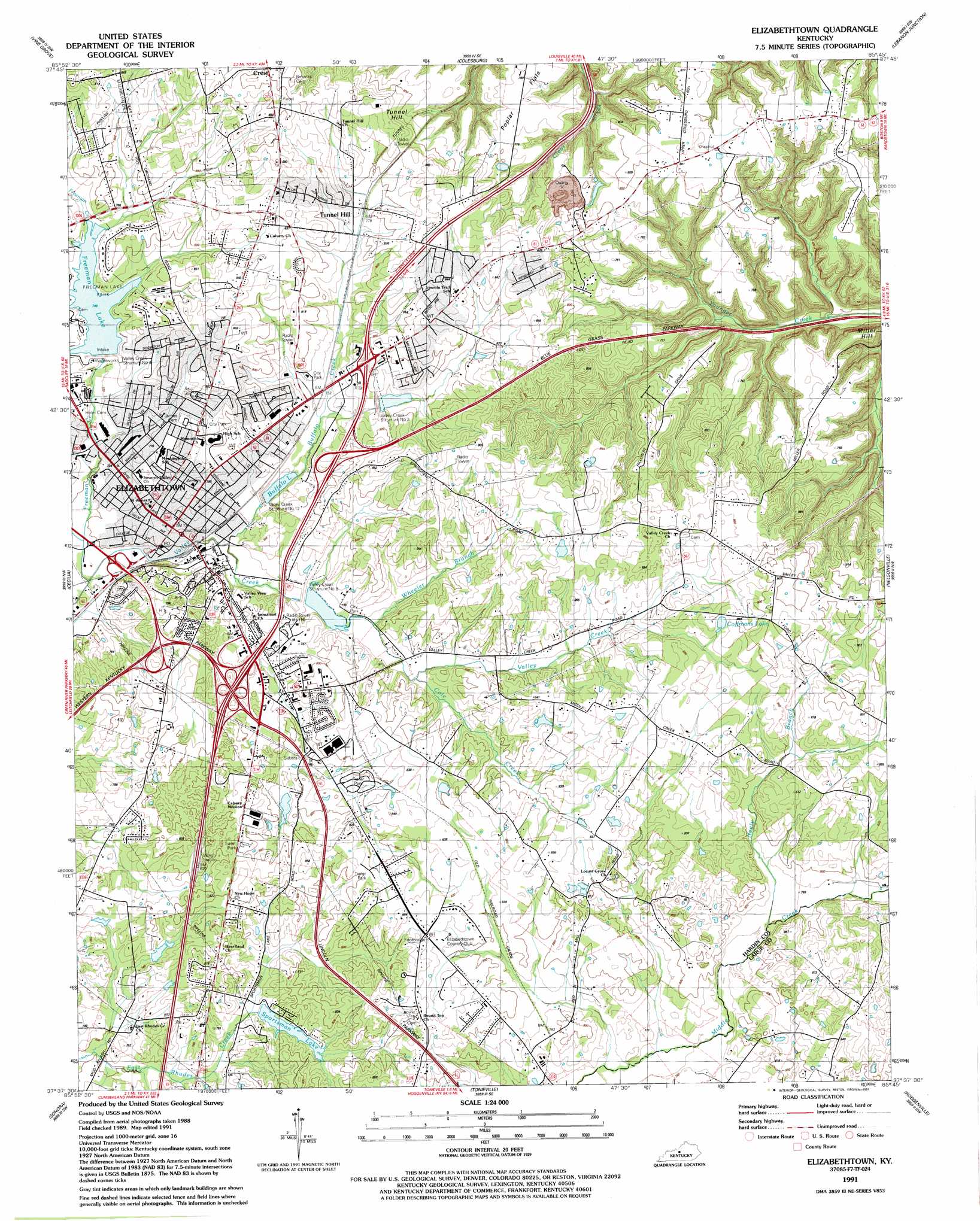
Elizabethtown Topo Map Kentucky
To zoom in, hover over the map of Elizabethtown
USGS Topo Quad 37085f7 - 1:24,000 scale
| Topo Map Name: | Elizabethtown |
| USGS Topo Quad ID: | 37085f7 |
| Print Size: | ca. 21 1/4" wide x 27" high |
| Southeast Coordinates: | 37.625° N latitude / 85.75° W longitude |
| Map Center Coordinates: | 37.6875° N latitude / 85.8125° W longitude |
| U.S. State: | KY |
| Filename: | o37085f7.jpg |
| Download Map JPG Image: | Elizabethtown topo map 1:24,000 scale |
| Map Type: | Topographic |
| Topo Series: | 7.5´ |
| Map Scale: | 1:24,000 |
| Source of Map Images: | United States Geological Survey (USGS) |
| Alternate Map Versions: |
Elizabethtown KY 1949, updated 1952 Download PDF Buy paper map Elizabethtown KY 1960, updated 1962 Download PDF Buy paper map Elizabethtown KY 1960, updated 1965 Download PDF Buy paper map Elizabethtown KY 1967, updated 1968 Download PDF Buy paper map Elizabethtown KY 1967, updated 1977 Download PDF Buy paper map Elizabethtown KY 1967, updated 1982 Download PDF Buy paper map Elizabethtown KY 1967, updated 1987 Download PDF Buy paper map Elizabethtown KY 1991, updated 1991 Download PDF Buy paper map Elizabethtown KY 2010 Download PDF Buy paper map Elizabethtown KY 2013 Download PDF Buy paper map Elizabethtown KY 2016 Download PDF Buy paper map |
1:24,000 Topo Quads surrounding Elizabethtown
Rock Haven |
Fort Knox |
Pitts Point |
Shepherdsville |
Samuels |
Flaherty |
Vine Grove |
Colesburg |
Lebanon Junction |
Cravens |
Howe Valley |
Cecilia |
Elizabethtown |
Nelsonville |
New Haven |
Summit |
Sonora |
Tonieville |
Hodgenville |
Howardstown |
Millerstown |
Upton |
Hammonville |
Magnolia |
Hibernia |
> Back to 37085e1 at 1:100,000 scale
> Back to 37084a1 at 1:250,000 scale
> Back to U.S. Topo Maps home
Elizabethtown topo map: Gazetteer
Elizabethtown: Dams
Structure Number 3 elevation 229m 751′Valley Creek Structure Number 12 elevation 223m 731′
Valley Creek Structure Number 4 elevation 228m 748′
Valley Creek Structure Number 8 elevation 238m 780′
Elizabethtown: Flats
Poplar Flats elevation 240m 787′Elizabethtown: Lakes
Coffmans Lake elevation 266m 872′Elizabethtown: Parks
Elizabethtown City Park elevation 250m 820′Freeman Lake Park elevation 232m 761′
Elizabethtown: Populated Places
Carter (historical) elevation 263m 862′Elizabethtown elevation 221m 725′
Indian Hills elevation 246m 807′
Tunnel Hills elevation 242m 793′
Elizabethtown: Reservoirs
Buffalo Lake elevation 221m 725′Freeman Lake elevation 228m 748′
Sportsman Lake elevation 228m 748′
Valley Creek Reservoir elevation 238m 780′
Elizabethtown: Streams
Buffalo Creek elevation 216m 708′Cole Creek elevation 226m 741′
Freeman Creek elevation 207m 679′
Neely Branch elevation 232m 761′
Shaw Creek elevation 209m 685′
Wheeler Branch elevation 223m 731′
Elizabethtown: Summits
Miller Hill elevation 231m 757′Tunnel Hill elevation 264m 866′
Elizabethtown digital topo map on disk
Buy this Elizabethtown topo map showing relief, roads, GPS coordinates and other geographical features, as a high-resolution digital map file on DVD: