Chaplin Topo Map Kentucky
To zoom in, hover over the map of Chaplin
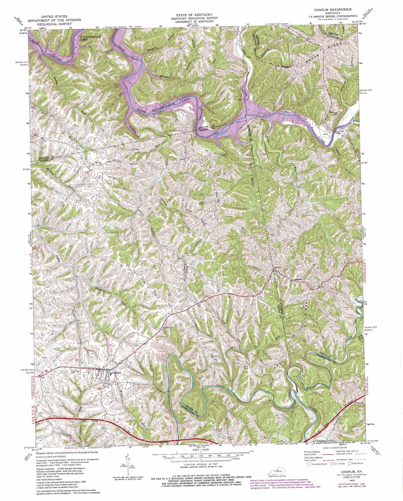
USGS Topo Quad 37085h2 - 1:24,000 scale
| Topo Map Name: | Chaplin |
| USGS Topo Quad ID: | 37085h2 |
| Print Size: | ca. 21 1/4" wide x 27" high |
| Southeast Coordinates: | 37.875° N latitude / 85.125° W longitude |
| Map Center Coordinates: | 37.9375° N latitude / 85.1875° W longitude |
| U.S. State: | KY |
| Filename: | o37085h2.jpg |
| Download Map JPG Image: | Chaplin topo map 1:24,000 scale |
| Map Type: | Topographic |
| Topo Series: | 7.5´ |
| Map Scale: | 1:24,000 |
| Source of Map Images: | United States Geological Survey (USGS) |
| Alternate Map Versions: |
Chaplin KY 1952, updated 1953 Download PDF Buy paper map Chaplin KY 1952, updated 1968 Download PDF Buy paper map Chaplin KY 1972, updated 1974 Download PDF Buy paper map Chaplin KY 1972, updated 1987 Download PDF Buy paper map Chaplin KY 2010 Download PDF Buy paper map Chaplin KY 2013 Download PDF Buy paper map Chaplin KY 2016 Download PDF Buy paper map |
1:24,000 Topo Quads surrounding Chaplin
Fisherville |
Simpsonville |
Shelbyville |
Waddy |
Frankfort West |
Waterford |
Taylorsville |
Mount Eden |
Glensboro |
Lawrenceburg |
Fairfield |
Bloomfield |
Chaplin |
Ashbrook |
Mcbrayer |
Bardstown |
Maud |
Brush Grove |
Cardwell |
Cornishville |
Loretto |
Saint Catherine |
Springfield |
Mackville |
Perryville |
> Back to 37085e1 at 1:100,000 scale
> Back to 37084a1 at 1:250,000 scale
> Back to U.S. Topo Maps home
Chaplin topo map: Gazetteer
Chaplin: Bridges
Goodnight Bridge elevation 166m 544′Chaplin: Crossings
Careys Little Mill Ford (historical) elevation 182m 597′Gordons Ford (historical) elevation 185m 606′
Chaplin: Populated Places
Chaplin elevation 251m 823′Monfort (historical) elevation 189m 620′
Sparrow elevation 252m 826′
Van Buren elevation 165m 541′
Chaplin: Post Offices
Colross Post Office (historical) elevation 228m 748′Howster Post Office (historical) elevation 165m 541′
Sparrow Post Office (historical) elevation 251m 823′
Van Buren Post Office (historical) elevation 165m 541′
Chaplin: Ridges
Love Ridge elevation 251m 823′Pleasant Grove Ridge elevation 234m 767′
Chaplin: Springs
Buffalo Lick (historical) elevation 168m 551′Chaplin: Streams
Beaver Creek elevation 181m 593′Chaplin Fork elevation 195m 639′
Crooked Creek elevation 165m 541′
Heddy Run elevation 165m 541′
Johnson Branch elevation 166m 544′
Levy Creek elevation 165m 541′
Long Run elevation 191m 626′
Mitchell Run elevation 165m 541′
Pigeon Branch elevation 184m 603′
Short Creek elevation 166m 544′
Stevens Run elevation 179m 587′
Sweazy Creek elevation 188m 616′
Timber Creek elevation 165m 541′
Watts Run elevation 165m 541′
Wide Lick elevation 193m 633′
Willow Creek elevation 169m 554′
Chaplin: Summits
Driscol Hill elevation 231m 757′Chaplin: Valleys
Poverty Hollow elevation 194m 636′Stoney Hollow elevation 185m 606′
Chaplin digital topo map on disk
Buy this Chaplin topo map showing relief, roads, GPS coordinates and other geographical features, as a high-resolution digital map file on DVD: